Geographic center of the United States
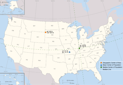
The geographic center of the United States is a point approximately 20 mi (32 km) north of Belle Fourche, South Dakota (Lat. 44 58 02.07622(N) Long. 103 46 17.60283(W)). It has been regarded as such by the U.S. National Geodetic Survey (NGS) since the additions of Alaska and Hawaii to the United States in 1959.
Overview
This is distinct from the contiguous geographic center, which reflects the 1912 additions of New Mexico and Arizona to the contiguous United States and falls near the town of Lebanon, Kansas.
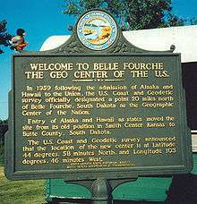
While any measurement of the exact center of a land mass will always be imprecise due to changing shorelines and other factors, the NGS coordinates identify an uninhabited parcel of private pastureland approximately 12 mi (19 km) east of the South Dakota/Wyoming/Montana border. It is recognized by a proxy marker in a park in Belle Fourche,[2] where one will find a flag atop a small concrete slab bearing a U.S. Coast and Geodetic Survey Reference Marker.
According to the NGS data sheet, the actual marker is "set in an irregular mass of concrete 36 inches below the surface of the ground."[3]
The addition of Alaska and Hawaii to the US moved the geographic center of the United States approximately 550 mi (885 km) Northwest by north.
See also
- Geographic center of the contiguous United States
- Geographic centers of the United States
- Mean center of United States population
- Median center of United States population
- Center of population
References
- ↑ Position of the Geographic Center of Area, Mean and Median Centers of Population: 2010 from the U.S. Census Bureau website
- ↑ http://www.hmdb.org/marker.asp?marker=4867
- ↑ http://www.ngs.noaa.gov/cgi-bin/ds_mark.prl?PidBox=PU2386 designates the "Center" as 44 58 02.07622(N) 103 46 17.60283(W)
External links
- In the Middle of Nowhere, a Nation’s Center, New York Times
Coordinates: 44°58′02″N 103°46′18″W / 44.967244°N 103.771555°W