Median center of United States population
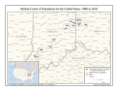
The median center of U.S. population is determined by the United States Census Bureau from the results of each census. The Bureau defines it to be:
the point though which a north-south line and an east-west line each divides the total population of the country in half.[2]
As of the 2010 U.S. census, this places roughly 154.4 million Americans living on each side of a longitude line passing through a location in Pike County, Indiana, and the same number living on each side of a latitude line through the same point.
During the 20th century the median center of U.S. population moved roughly 180 mi (290 km) southwest, from a location in Randolph County, Indiana to a location in Daviess County, Indiana. The majority of this southwest shift happened in the second half of the century, as the center shifted within a narrow circular band between 1900 and 1950 – all within roughly 25 mi (40 km) of the 1900 starting point in Randolph County.
See also
- Mean center of United States population
- Center of population
- Geographic center of the United States
- Geographic center of the contiguous United States
References
- ↑ Median Center of Population for the United States: 1880 to 2010 from the U.S. Census Bureau website
- ↑ Centers of Population Computation Documentation from the U.S. Census Bureau website