George Wallace Tunnel
|
Map of the Wallace (lower) and Bankhead (upper) tunnels under the Mobile River. | |
| Overview | |
|---|---|
| Official name | George Corley Wallace Tunnel |
| Other name(s) | Wallace Tunnel |
| Location | Mobile River, Mobile, Alabama |
| Coordinates | 30°41′24″N 88°02′08″W / 30.69000°N 88.03556°W |
| Route |
|
| Operation | |
| Opened | 1973 |
| Traffic | 66,110 (2007) |
| Character | Dual four-lane road tunnel |
| Toll | none |
| Technical | |
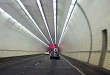
| Length | 3,000 feet (914 m) |
| Number of lanes | 4 |
| Tunnel clearance | 16 feet (5 m) |
| Depth of tunnel below water level | 40 feet (12 m) (from surface to top of tunnel) |

The George Wallace Tunnel is a pair of road tunnels that carry Interstate 10 in Mobile, Alabama from the city's downtown, beneath the Mobile River, and emerge on Blakeley Island where they join the Jubilee Parkway over Mobile Bay.[1]
It, like the smaller Bankhead Tunnel a few blocks upriver from it, was constructed in Mobile at the shipyards of the Alabama Drydock and Shipbuilding Company (ADDSCO) from 1969-1973.[1] The George Corley Wallace Tunnel, actually two separate tunnels (one for two lanes of travel eastbound, and one for two lanes of travel westbound on Interstate 10), was built in sections and floated to the proper positions, then sunk. Each section was sunk next to the previous section and joined underwater. When all sections were connected, and concrete set into place, they were pumped dry and finished out. The depth of clearance is 40 ft (12.2 m) for the ship channel over the tunnel.[1] This is the same clearance as the older Bankhead Tunnel.
Entrances

The George C. Wallace Tunnel, like the Bankhead Tunnel, emerges on the west end under Royal Street, in downtown Mobile (see map); however, whereas the Bankhead Tunnel emerges at street level joining into Government Street, the George C. Wallace Tunnel slopes upward to continue Interstate 10 as an elevated highway above the Mobile streets. On the eastern end, over Blakeley Island, the George C. Wallace Tunnel again slopes upward becoming the elevated spans of I-10, which cross Mobile Bay eastward, along the twin bridges of the curved I-10 Jubilee Parkway.
The western approach of the tunnel features a sharp curve which causes lengthy traffic backups in each direction depending on demand, and is part of the impetus to study a replacement for the tunnel.
Nearby construction
In the area where the George C. Wallace Tunnel passes beneath downtown Mobile, the re-filled area was later topped with a reconstruction of Fort Conde and several other new buildings, extending from the Mobile River for several blocks, along Water Street and Commerce Street. Because the tunnel tubes emerge within downtown Mobile, the riverbank along the Mobile River appears as an unbroken, continuous waterfront, with no other signs of the tunnels below.
See also
| Wikimedia Commons has media related to George Wallace Tunnel. |
- Fort Conde - Partial replica fort built above the tunnel during the 1970s to commemorate the French colonial-era Fort Condé at the site.
References
- 1 2 3 "Frequently Asked Questions" (notes), Mobile Area Chamber of Commerce, 2006. MCCOM-FAQ web page
| Crossings of the Mobile River | ||||
|---|---|---|---|---|
| ||||