Georgia State Route 105
| ||||
|---|---|---|---|---|
|
Georgia State Route 105 highlighted in red | ||||
| Route information | ||||
| Maintained by GDOT | ||||
| Length: | 23.1 mi[1] (37.2 km) | |||
| Major junctions | ||||
| West end: |
| |||
|
| ||||
| East end: |
| |||
| Location | ||||
| Counties: | Habersham, Banks, Stephens, Franklin | |||
| Highway system | ||||
| ||||

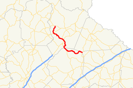
State Route 105 (SR 105) is a 23.1-mile-long (37.2 km) state highway in the northeastern part of the U.S. state of Georgia. The highway travels from Harvest, northwest of Clarkesville, southeast through rural portions of Habersham and Banks counties to a point in rural northeastern Banks County. Approximately 1.2 miles (1.9 km) before it reaches its eastern terminus, it travels along the Banks-Stephens county line. Its eastern terminus is at the meeting point of Banks, Stephens, and Franklin counties.
The entire section concurrent with SR 385 travels along the historic route of U.S. Route 441 (US 441).
Route description
SR 105 begins at an intersection with SR 17 in Harvest, in Habersham County. It travels to the south-southwest to an intersection with SR 115, in Colson Store. The route heads southeast, and crosses the Soquee River before intersecting US 441 Business/SR 385 in Cornelia. The three routes begin a concurrency to the southeast. Just after the beginning of the concurrency is an intersection with US 23/US 441/SR 15/SR 365. At this intersection, SR 385 ends and SR 105's concurrency with US 441 Business continues to the south-southeast. The two highways curve to the south-southwest and enter Baldwin, where the concurrency intersects US 441/SR 15, at which point, US 441 Business ends. US 441/SR 15/SR 105 travel concurrently to the south-southeast. The three highways enter Banks County and leave the city limits of Baldwin; then, they enter the Chattahoochee-Oconee National Forest. Here, SR 105 departs the concurrency to the east. SR 105 twists and turns through Rural areas of the county and crosses the Middle Fork Broad River. After more twists and turns, it travels along the Banks–Stephens county line for just under 1 mile (1.6 km). It enters Stephens County proper and meets its eastern terminus, an intersection with SR 184 on the Stephens–Franklin county line, west-southwest of Mize.[1]
SR 105 is not part of the National Highway System, a system of roadways important to the nation's economy, defense, and mobility.[2]
Major intersections
| County | Location | mi[1] | km | Destinations | Notes | |||
|---|---|---|---|---|---|---|---|---|
| Habersham | Harvest | 0.0 | 0.0 | Northern terminus | ||||
| Colson Store | 3.6 | 5.8 | ||||||
| Cornelia | 8.4 | 13.5 | Western end of US 441 Bus./SR 385 concurrency | |||||
| 8.9 | 14.3 | Southern terminus of SR 385; eastern end of SR 385 concurrency | ||||||
| Baldwin | 12.7 | 20.4 | Southern terminus of US 441 Bus.; eastern end of US 441 Bus. concurrency; western end of US 441/SR 15 concurrency | |||||
| Banks | Chattahoochee-Oconee National Forest | 14.6 | 23.5 | Eastern end of US 441/SR 15 concurrency | ||||
| Banks–Stephens |
No major junctions | |||||||
| Stephens |
No major junctions | |||||||
| Stephens–Franklin county line | 23.1 | 37.2 | Eastern terminus | |||||
1.000 mi = 1.609 km; 1.000 km = 0.621 mi
| ||||||||
See also
-
.svg.png) Georgia (U.S. state) portal
Georgia (U.S. state) portal -
 U.S. Roads portal
References
- 1 2 3 Google (October 21, 2012). "Route of SR 105" (Map). Google Maps. Google. Retrieved October 21, 2012.
- ↑ National Highway System: (Draft) Georgia (PDF) (Map). Federal Highway Administration. November 15, 2013. Retrieved May 14, 2014.