Georgia State Route 184
| ||||
|---|---|---|---|---|
 | ||||
| Route information | ||||
| Maintained by GDOT | ||||
| Length: | 19.4 mi[1] (31.2 km) | |||
| Major junctions | ||||
| South end: |
| |||
|
| ||||
| North end: | Cleveland Pike Road at the South Carolina state line west of Westminster, South Carolina | |||
| Location | ||||
| Counties: | Banks, Franklin, Stephens | |||
| Highway system | ||||
| ||||

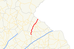
State Route 184 (SR 184) is a 19.4-mile (31.2 km) state highway that runs south-to-north through portions of Banks and Stephens counties in the northeastern part of the U.S. state of Georgia. The route's southern terminus is at SR 63 in northeastern Banks County. The northern terminus at the Tugaloo River and the South Carolina state line where the road continues as Cleveland Pike Road.
Route description
SR 184 begins at an intersection with SR 63 in the northeastern section of Banks County. It travels northwest on Martins Bridge Road briefly until turning right onto Damascus Road. To the north-northeast, the route enters the extreme northwest corner of Franklin County and reaches the meeting point of Banks, Franklin, and Stephens counties.[2] It intersects the southern terminus of SR 105, and then runs along the Franklin–Stephens county line and forms the southern border of the Chattahoochee National Forest.[3][1]
SR 184 is now wholly inside the boundaries of the Chattahoochee National Forest and carries the name Homer Road and travels north towards the community of Boydville. There, it makes a right turn at Dicks Hill Parkway and intersects US 123/SR 17/SR 365. US 123/SR 365 begin a concurrency with SR 184, which now bears the name Currahee Street, and travel north into Toccoa, while SR 17 continues to the east. Between Boydville and Toccoa city limits, the road is again the boundary line for the Chattahoochee Forest. In downtown Toccoa, SR 184 leaves the concurrency at the intersection of Currahee Street and Broad Street by turning north onto Broad Street while the other two routes stay on Currahee Street. This intersection is also the northern terminus of SR 63/SR 106, which head south on Broad Street. After passing under the Norfolk Southern Railway underpass, SR 184 turns right onto Tugalo Street forming a wrong-way concurrency with SR 17 Alternate.[4][1]
After about 0.7 miles (1.1 km), SR 184 turns left onto Prather Bridge Road while SR 17 Alternate continues east on Tugalo Street. As SR 184 leaves Toccoa's city limits, it is again in the Chattahoochee Forest as it travels northeast towards the Tugaloo River. The road crosses into South Carolina on a bridge over the river. Here, the Georgia state route ends and Cleveland Pike Road continues into Oconee County as a state secondary route.[5][1]
Major intersections
| County | Location | mi[1] | km | Destinations | Notes |
|---|---|---|---|---|---|
| Banks | | 0.0 | 0.0 | Southern terminus | |
| Franklin | Chattahoochee National Forest | 2.5 | 4.0 | Southern terminus of SR 105 | |
| Stephens | 9.5 | 15.3 | Southern end of US 123/SR 365 concurrency | ||
| Toccoa | 12.8 | 20.6 | Northern end of US 123/SR 365 concurrency; northern terminus of SR 63/SR 106 | ||
| 12.9 | 20.8 | Southern end of SR 17 Alternate concurrency | |||
| 13.6 | 21.9 | Northern end of SR 17 Alternate concurrency | |||
| Chattahoochee National Forest | 19.4 | 31.2 | Cleveland Pike Road | South Carolina state line | |
1.000 mi = 1.609 km; 1.000 km = 0.621 mi
| |||||
See also
-
.svg.png) Georgia (U.S. state) portal
Georgia (U.S. state) portal -
 U.S. Roads portal
References
- 1 2 3 4 5 Google (June 22, 2013). "Route of SR 184" (Map). Google Maps. Google. Retrieved June 22, 2013.
- ↑ General Highway Map - Banks County, Georgia (PDF) (Map). Georgia Department of Transportation. 2013. Retrieved June 22, 2013.
- ↑ General Highway Map - Franklin County, Georgia (PDF) (Map). Georgia Department of Transportation. 2013. Retrieved June 22, 2013.
- ↑ General Highway Map - Stephens County, Georgia (PDF) (Map). Georgia Department of Transportation. 2013. Retrieved June 22, 2013.
- ↑ General Highway System - Oconee County, South Carolina (PDF) (Map). South Carolina Department of Transportation. August 2005. Retrieved January 8, 2013.