Georgia State Route 264
| ||||
|---|---|---|---|---|
| Bethany Church Road | ||||
 | ||||
| Route information | ||||
| Maintained by GDOT | ||||
| Length: | 2.7 mi[1] (4.3 km) | |||
| Existed: | 1949[2][3] – present | |||
| Major junctions | ||||
| West end: |
| |||
| East end: |
| |||
| Location | ||||
| Counties: | Gwinnett | |||
| Highway system | ||||
| ||||

State Route 264 (SR 264) is a northwest-southeast state highway located in the eastern part of the Atlanta metropolitan area in the U.S. state of Georgia. Its route is entirely within Gwinnett County.
Route description
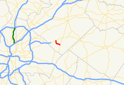
SR 264 begins at an intersection with US 78/SR 10 (Stone Mountain Highway) southwest of Snellville. Here, the roadway continues as Killian Hill Road SW. Just after its western terminus, the route runs along the west side of the Mountain View Village Shopping Center. South of the shopping center is Shiloh Road, which leads to Shiloh Elementary School, Shiloh Middle School, and Shiloh High School. The road curves to the southeast and crosses Jacks Creek. Southeast of that crossing is Centerville Public Library. SR 264 continues to the southeast, until it meets its eastern terminus, an intersection with SR 124 (Centerville Highway) north of Centerville. At its eastern terminus, the roadway continues as Zoar Road SW. The route is known as Bethany Church Road for its entire length.[1]
No section of SR 264 is part of the National Highway System, a system of routes determined to be the most important for the nation's economy, mobility and defense.[4]
History
SR 264 was established in 1949 along the same alignment as it runs today.[2][3] By 1955, the entire route was paved.[5][6]
Major intersections
The entire route is in Gwinnett County.
| Location | mi[1] | km | Destinations | Notes | |
|---|---|---|---|---|---|
| | 0.0 | 0.0 | Western terminus; roadway continues as Killian Hill Road SW. | ||
| | 2.7 | 4.3 | Eastern terminus; roadway continues as Zoar Road SW. | ||
| 1.000 mi = 1.609 km; 1.000 km = 0.621 mi | |||||
See also
-
.svg.png) Georgia (U.S. state) portal
Georgia (U.S. state) portal -
 U.S. Roads portal
References
- 1 2 3 Google (February 19, 2013). "Route of SR 264" (Map). Google Maps. Google. Retrieved February 19, 2013.
- 1 2 Georgia State Highway System (PDF) (Map). Cartography by GSHD. Georgia State Highway Department. February 28, 1948. Retrieved February 19, 2013.
- 1 2 Georgia State Highway System (PDF) (Map). Cartography by GSHD. Georgia State Highway Department. April 1, 1949. Retrieved February 19, 2013.
- ↑ "National Highway System: Georgia" (PDF). United States Department of Transportation. May 8, 2009. Retrieved February 19, 2013.
- ↑ Georgia State Highway System (PDF) (Map). Cartography by GSHD. Georgia State Highway Department. June 1, 1954. Retrieved February 19, 2013.
- ↑ Georgia State Highway System (PDF) (Map). Cartography by GSHD. Georgia State Highway Department. June 1, 1955. Retrieved February 19, 2013.