Georgia State Route 370
| ||||
|---|---|---|---|---|
 | ||||
| Route information | ||||
| Maintained by GDOT | ||||
| Length: | 12.6 mi[1] (20.3 km) | |||
| Existed: | 1970[2][3] – present | |||
| Major junctions | ||||
| South end: |
| |||
|
| ||||
| Northeast end: |
| |||
| Location | ||||
| Counties: | Early | |||
| Highway system | ||||
| ||||

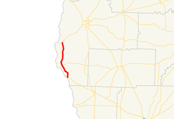
State Route 370 (SR 370) is a 12.6-mile-long (20.3 km) north–south state highway located entirely within Early County in the southwestern part of the state of Georgia. It travels parallel to the Chattahoochee River for its entire length. The southern-most 1.5 miles (2.4 km) is part of the Blakely Highway. The rest of the highway is known as Great Southern Highway. The roadway's construction began in the early 1960s. Later that decade, the Blakely Highway section was included as part of former SR 363. In 1970, the road was designated as SR 370.
Route description
SR 370 begins at an intersection with US 84/SR 38 (Hugh D. Broome, Sr. Parkway) northwest of Jakin. Approximately 4.6 miles (7.4 km) north-northwest of the southern terminus, SR 370 intersects the western terminus of SR 273 (Paper Mill Parkway) and the eastern terminus of SR 273 Spur. Finally, the route curves to a nearly due north routing and meets its northern terminus, an intersection with SR 62 (Columbia Highway) in Hilton.[1] SR 370 is the first and last state route on State Route 62 and 84.
SR 370 is not part of the National Highway System, a system of roadways important to the nation's economy, defense, and mobility.[4]
History
The road that would eventually become SR 370 was built between 1960 and 1963 from its current southern terminus to approximately 1.5 miles (2.4 km) north of that point.[5][6] In 1967, this entire segment was designated as part of SR 363.[7][8] In 1970, SR 370 was designated along its current length from approximately 1.5 miles (2.4 km) north of its current southern terminus to its current northern terminus. It is unclear if it traveled concurrent with SR 363 south of the southern end of this segment.[2][3] Between 1984 and 1986, SR 363 was decommissioned. SR 370 was designated along its current length.[9][10]
Major intersections
The entire route is in Early County.
| Location | mi[1] | km | Destinations | Notes | |
|---|---|---|---|---|---|
| Saffold | 0.0 | 0.0 | Southern terminus | ||
| | 4.6 | 7.4 | Western terminus of SR 273; eastern terminus of SR 273 Spur | ||
| Hilton | 12.6 | 20.3 | Northern terminus | ||
| 1.000 mi = 1.609 km; 1.000 km = 0.621 mi | |||||
See also
-
.svg.png) Georgia (U.S. state) portal
Georgia (U.S. state) portal -
 U.S. Roads portal
References
- 1 2 3 Google (October 29, 2013). "Route of SR 370" (Map). Google Maps. Google. Retrieved October 29, 2013.
- 1 2 Georgia State Highway System (PDF) (Map). Cartography by GSHD. Georgia State Highway Department. January 1, 1970. Retrieved August 14, 2015.
- 1 2 Georgia State Highway System (PDF) (Map). Cartography by GSHD. Georgia State Highway Department. January 1, 1971. Retrieved August 14, 2015.
- ↑ "National Highway System: Georgia" (PDF). Federal Highway Administration. October 1, 2012. Retrieved October 21, 2013.
- ↑ Georgia State Highway System (PDF) (Map). Cartography by GSHD. Georgia State Highway Department. June 1, 1960. Retrieved August 14, 2015.
- ↑ Georgia State Highway System (PDF) (Map). Cartography by GSHD. Georgia State Highway Department. June 1, 1963. Retrieved August 14, 2015.
- ↑ Georgia State Highway System (PDF) (Map). Cartography by GSHD. Georgia State Highway Department. January 1, 1967. Retrieved August 14, 2015.
- ↑ Georgia State Highway System (PDF) (Map). Cartography by GSHD. Georgia State Highway Department. January 1, 1968. Retrieved August 14, 2015.
- ↑ Georgia State Highway System (PDF) (Map). Cartography by GSHD. Georgia State Highway Department. January 1, 1984. Retrieved August 14, 2015.
- ↑ Georgia State Highway System (PDF) (Map). Cartography by GSHD. Georgia State Highway Department. January 1, 1986. Retrieved August 14, 2015.