Blakely, Georgia
| Blakely, Georgia | |
|---|---|
| City | |
|
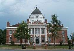
Early County Courthouse in Blakely | |
| Nickname(s): Peanut Capital of the Universe | |
 Location in Early County and the state of Georgia | |
| Coordinates: 31°22′36″N 84°56′2″W / 31.37667°N 84.93389°WCoordinates: 31°22′36″N 84°56′2″W / 31.37667°N 84.93389°W | |
| Country | United States |
| State | Georgia |
| County | Early |
| Government | |
| • Mayor | Anthony Howard |
| Area | |
| • Total | 17.6 sq mi (45.6 km2) |
| • Land | 17.5 sq mi (45.3 km2) |
| • Water | 0.4 sq mi (0.3 km2) |
| Elevation | 262 ft (80 m) |
| Population (2010) | |
| • Total | 5,068 |
| • Density | 323.6/sq mi (124.9/km2) |
| Time zone | Eastern (EST) (UTC-5) |
| • Summer (DST) | EDT (UTC-4) |
| ZIP codes | 31723, 39823 |
| Area code(s) | 229 |
| FIPS code | 13-08536[1] |
| GNIS feature ID | 0331185[2] |
The town of Blakely is the county seat[3] of Early County, Georgia. As of the 2010 census, it had a population of 5,068.[4]
History
Blakely was platted in 1825 as the county seat for Early County. It was named for Johnston Blakeley, an officer in the War of 1812.[5]
Geography
Blakely is located at 31°22′36″N 84°56′2″W / 31.37667°N 84.93389°W (31.376728, -84.933873).[6] The city is located in southwestern Georgia along U.S. Route 27, Georgia State Route 62, and Georgia State Route 39. Blakely is located approximately 75 mi (121 km) south of Columbus, 48 mi (77 km) southwest of Albany, and 76 mi (122 km) northwest of Tallahassee, Florida and 24 miles northeast of Dothan, Alabama.
According to the United States Census Bureau, this town has a total area of 17.6 square miles (46 km2), of which, 17.5 square miles (45 km2) is land and 0.1 square miles (0.26 km2) (0.74%) is water.
Demographics
| Historical population | |||
|---|---|---|---|
| Census | Pop. | %± | |
| 1880 | 279 | — | |
| 1890 | 441 | 58.1% | |
| 1900 | 804 | 82.3% | |
| 1910 | 1,838 | 128.6% | |
| 1920 | 1,985 | 8.0% | |
| 1930 | 2,106 | 6.1% | |
| 1940 | 2,774 | 31.7% | |
| 1950 | 3,234 | 16.6% | |
| 1960 | 3,580 | 10.7% | |
| 1970 | 5,267 | 47.1% | |
| 1980 | 5,880 | 11.6% | |
| 1990 | 5,595 | −4.8% | |
| 2000 | 5,696 | 1.8% | |
| 2010 | 5,068 | −11.0% | |
| Est. 2015 | 4,871 | [7] | −3.9% |
As of the census[1] of 2000, there were 5,696 people, 2,060 households, and 1,413 families residing in this town. The population density was 326.0 people per square mile (125.9/km²). There were 2,251 housing units at an average density of 128.8 per square mile (49.7/km²). The racial makeup of the city was 38.34% White, 59.97% African American, 0.19% Native American, 0.32% Asian, 0.12% Pacific Islander, 0.40% from other races, and 0.65% from two or more races. Hispanic or Latino of any race were 1.54% of the population.
There were 2,060 households out of which 34.5% had children under the age of 18 living with them, 35.5% were married couples living together, 29.2% had a female householder with no husband present, and 31.4% were non-families. 28.0% of all households were made up of individuals and 13.8% had someone living alone who was 65 years of age or older. The average household size was 2.64 and the average family size was 3.25.
In the city the population was spread out with 31.9% under the age of 18, 8.1% from 18 to 24, 24.7% from 25 to 44, 18.8% from 45 to 64, and 16.5% who were 65 years of age or older. The median age was 34 years. For every 100 females there were 81.2 males. For every 100 females age 18 and over, there were 71.2 males.
The median income for a household in the city was $20,250, and the median income for a family was $24,107. Males had a median income of $24,861 versus $16,116 for females. The per capita income for the city was $12,012. About 29.6% of families and 33.6% of the population were below the poverty line, including 50.7% of those under age 18 and 22.7% of those age 65 or over.
Other
The Peanut Corporation of America had a factory in Blakely that produced peanut paste (which is in turn used by other manufacturers in other foods). FBI and FDA officials said the plant's officials and workers were suspected of spreading salmonella bacteria in 2007-2009 by knowingly allowing products that had tested positive to be re-tested as negatives (giving a false-negative second result) and then allowing them to be shipped out despite the fact they could have been positive. This likely contributed to numerous illnesses and at least eight deaths. As a result, the FDA and FBI became involved, leading a U.S. Justice Department criminal investigation. Several lawsuits were filed by victims' relatives, and a massive nationwide recall of many products took place. The company shut the plant and laid off all of the plant’s roughly 50 employees for the duration of the investigation, which caused economic hardship for the town during the 2009 recession.
The non-profit group Early County 2055 established its headquarters on Court Square in Blakely. Funding for the long-term development plan for the revitalization of the city and county was led by the Charles Rice Family and Foundation.
Blakely is the base of the Early County School System, which has a newly renovated football stadium and gymnasium. Blakely also opened a new sportsplex, named in memorial and honor of local coach Ray Knight. It has multiple softball, baseball, and multi-purpose fields, and is operated by the Blakely-Early County Recreation Department.
Education
Early County School District
The Early County School District holds grades pre-school to grade twelve, and consists of one elementary school, a middle school, and a high school.[9] The district has 156 full-time teachers and over 2,764 students.[10]
- Early County Elementary School
- Early County Middle School
- Early County High School
Alternative School
- Learning and Opportunity Academy
Notable people
The actress Whitney Houston's ancestors are from Blakely. Her maternal grandfather, Nitcholas Drinkard, was born to Susan Bell (Fuller) Drinkard (born 1876), of African-American and Dutch descent, and John Drinkard, Jr. (born 1870), of African-American and Native American descent. His ancestors included African-American landowners in Blakely. The Drinkards owned a substantial amount of farmland during a time when it was unusual for blacks to own large portions of land. The asset was gradually depleted as small portions of the land were sold to resolve continued legal troubles of a close relative.
References
- 1 2 "American FactFinder". United States Census Bureau. Archived from the original on 2013-09-11. Retrieved 2008-01-31.
- ↑ "US Board on Geographic Names". United States Geological Survey. 2007-10-25. Retrieved 2008-01-31.
- ↑ "Find a County". National Association of Counties. Archived from the original on 2011-05-31. Retrieved 2011-06-07.
- ↑ http://factfinder2.census.gov/faces/tableservices/jsf/pages/productview.xhtml?pid=DEC_10_SF1_GCTP2.ST13&prodType=table
- ↑ Hellmann, Paul T. (May 13, 2013). Historical Gazetteer of the United States. Routledge. p. 221. Retrieved 30 November 2013.
- ↑ "US Gazetteer files: 2010, 2000, and 1990". United States Census Bureau. 2011-02-12. Retrieved 2011-04-23.
- ↑ "Annual Estimates of the Resident Population for Incorporated Places: April 1, 2010 to July 1, 2015". Retrieved July 2, 2016.
- ↑ "Census of Population and Housing". Census.gov. Archived from the original on May 11, 2015. Retrieved June 4, 2015.
- ↑ Georgia Board of Education, Retrieved June 8, 2010.
- ↑ School Stats, Retrieved June 8, 2010.
External links
- Blakely - Early County Chamber of Commerce - Chamber of Commerce for Blakely and surrounding communities of Jakin, Arlington, and Damascus
- Early County Board of Education - serving the city of Blakely and surrounding communities of Jakin, Arlington, and Damascus
- Early County News - a newspaper founded by the Fleming family in 1859


Municipalities and communities of Early County, Georgia, United States | ||
|---|---|---|
| Cities | 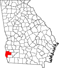 | |
| CDP | ||
| Unincorporated community | ||
| Footnotes | ‡This populated place also has portions in an adjacent county or counties | |