Georgia State Route 43
| ||||
|---|---|---|---|---|
 | ||||
| Route information | ||||
| Maintained by GDOT | ||||
| Length: | 25.7 mi[1] (41.4 km) | |||
| Major junctions | ||||
| South end: |
| |||
|
| ||||
| North end: |
| |||
| Location | ||||
| Counties: | McDuffie, Lincoln | |||
| Highway system | ||||
| ||||

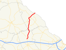
State Route 43 (SR 43) is a 25.7-mile-long (41.4 km) state highway that runs southwest-to-northeast through portions of McDuffie and Lincoln counties in the east-central part of the U.S. state of Georgia. The route connects the northern part of the Thomson area to the South Carolina state line, via Lincolnton.
Route description
SR 43 beins at an intersection with US 78/SR 10/SR 17 (Washington Road) north of Thomson in McDuffie County. It heads north-northeast, crossing over the Little River on the Raysville Bridge. On this bridge, it crosses into Lincoln County just east of the meeting point of McDuffie, Wilkes, and Lincoln counties. It continues to the north-northeast, and intersects SR 220 in the southern portion of the county, just south-southwest of Loco. It continues its routing and curves to the northwest into Lincolnton. In town, SR 43 intersects SR 47 (Elm Avenue). The two routes travel concurrent for about 600 feet (180 m) to the west. Farther to the west, they meet US 378. At this intersection, SR 43 and SR 47 diverge; SR 43 runs concurrent with US 378 eastbound, and SR 47 runs concurrent with US 378 westbound. US 378/SR 43 remain concurrent to the South Carolina state line, where SR 43 meets its northern terminus and US 378 continues to McCormick, South Carolina.
SR 43 is not part of the National Highway System, a system of roadways important to the nation's economy, defense, and mobility.[2]
Major intersections
| County | Location | mi[1] | km | Destinations | Notes |
|---|---|---|---|---|---|
| McDuffie | | 0.0 | 0.0 | Southern terminus | |
| Little River | 7.4 | 11.9 | Raysville Bridge; marking the McDuffie–Lincoln county line | ||
| Lincoln | | 12.8 | 20.6 | ||
| Lincolnton | 18.2 | 29.3 | Southern end of SR 47 concurrency | ||
| 18.4 | 29.6 | Northern end of SR 47 concurrency; southern end of US 378 concurrency | |||
| 19.5 | 31.4 | Southern terminus of SR 79 | |||
| Clarks Hill Lake | 22.9 | 36.9 | Unnamed bridge | Crossing over Clarks Hill Lake | |
| | 24.3 | 39.1 | Northern terminus of SR 220 | ||
| Savannah River | 25.7 | 41.4 | Northern terminus; unnamed bridge; crossing over the Savannah River into South Carolina; northern end of US 378 concurrency; roadway continues as | ||
1.000 mi = 1.609 km; 1.000 km = 0.621 mi
| |||||
See also
-
.svg.png) Georgia (U.S. state) portal
Georgia (U.S. state) portal -
 U.S. Roads portal
 - Central Savannah River Area
References
- 1 2 Google (August 2, 2013). "Route of SR 43" (Map). Google Maps. Google. Retrieved August 2, 2013.
- ↑ "National Highway System: Georgia" (PDF). United States Department of Transportation. October 1, 2012. Retrieved August 2, 2013.