Georgia State Route 75
| ||||
|---|---|---|---|---|
 | ||||
| Route information | ||||
| Maintained by GDOT | ||||
| Length: | 33.4 mi[1] (53.8 km) | |||
| Major junctions | ||||
| South end: |
| |||
|
| ||||
| North end: |
| |||
| Location | ||||
| Counties: | White, Towns | |||
| Highway system | ||||
| ||||

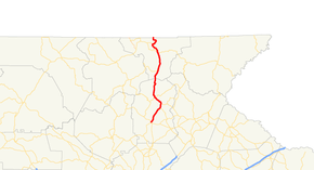
State Route 75 (SR 75) is a 33.4-mile-long (53.8 km) state highway that runs south-to-north through portions of White and Towns counties in the northern part of the U.S. state of Georgia. It connects the towns of Cleveland and Hiawassee, with Helen, Macedonia and the North Carolina state line.
Route description
SR 75 begins at an intersection with US 129/SR 11 (North Main Street) in Cleveland in White County. This intersection also marks the southern terminus of SR 75 Alternate, which runs concurrent with US 129/SR 11 to the northwest. SR 75 heads north-northeast, past White County Park, to an intersection with the northern terminus of SR 384. About 1.2 miles (1.9 km) later, the road crosses over the Chattahoochee River. Then, SR 17 (Unicoi Turnpike) begins a concurrency with it to the northwest. Immediately after is another crossing of the Chattahoochee River. In Helen, a Germany-themed town, they cross over the river again. They begin to parallel the river to the northwest. Just outside town, they meet the northern terminus of SR 75 Alternate and enter the Chattahoochee-Oconee National Forest. They head north and north-northeast on a curving fashion through the North Georgia mountains and cross into Towns County. They meet the eastern terminus of SR 180 and parallel the Hiawassee River for a while, before crossing over the river and heading to the north-northwest. They begin a concurrency with US 76/SR 2, just to the west of Macedonia. The four highways meet the eastern terminus of SR 288 and cross over a portion of Chatuge Lake. Then, they head northwest to the town of Hiawassee. In the northern part of town, SR 75 splits off to the northeast. It curves to the northwest, and circles back to the northwest, before leaving the Chattahoochee-Oconee National Forest, heads west, and curves to the north. It heads due north before a gradual curve to the north-northeast, just before meeting its northern terminus, the North Carolina state line. Here, the roadway continues as North Carolina Highway 175.[1]
SR 75 is not part of the National Highway System, a system of roadways important to the nation's economy, defense, and mobility.[2]
History
The original southern terminus was at Georgia State Route 254 near the Mossy Creek and Skitt Mountain Golf Courses. This segment ran northwest into US 129/SR 11 and multiplexed with those routes until it reached Helen Way. Today, the segment between SR 254 and US 129 is named "Old Highway 75 South."
Major intersections
| County | Location | mi[1] | km | Destinations | Notes |
|---|---|---|---|---|---|
| White | Cleveland | 0.0 | 0.0 | Southern terminus of SR 75; southern terminus of SR 75 Alternate | |
| | 5.4 | 8.7 | Northern terminus of SR 384 | ||
| Chattahoochee River | 6.6 | 10.6 | Unnamed bridge | Crossing over the Chattahoochee River | |
| | 6.8 | 10.9 | Southern end of SR 17 concurrency | ||
| Chattahoochee River | 7.0 | 11.3 | Unnamed bridge | Crossing over the Chattahoochee River | |
| Helen | 8.6 | 13.8 | Unnamed bridge | Crossing over the Chattahoochee River | |
| Chattahoochee-Oconee National Forest | 10.0 | 16.1 | Northern terminus of SR 75 Alternate | ||
| Towns | 20.4 | 32.8 | Eastern terminus of SR 180 | ||
| Hiawassee River | 25.5 | 41.0 | Unnamed bridge | Crossing over the Hiawassee River | |
| | 26.7 | 43.0 | Southern end of US 76/SR 2 concurrency | ||
| Chattahoochee-Oconee National Forest | 26.9 | 43.3 | Eastern terminus of SR 288 | ||
| Chatuge Lake | 27.0 | 43.5 | Unnamed bridge | Crossing over Chatuge Lake | |
| Hiawassee | 29.9 | 48.1 | Northern end of US 76/SR 2 & SR 17 concurrencies | ||
| North Carolina state line | 33.4 | 53.8 | Northern terminus | ||
1.000 mi = 1.609 km; 1.000 km = 0.621 mi
| |||||
Bannered routes
Cleveland alternate
| |
|---|---|
| Location: | Cleveland and rural White County |
| Length: | 11.1 mi[3] (17.9 km) |
State Route 75 Alternate (SR 75 Alternate) is an 11.1-mile-long (17.9 km) alternate route that exists entirely within the central part of White County.
It begins at an intersection with US 129/SR 11 (North Main Street), where they meet the southern terminus of the SR 75 mainline (Helen Highway) in Cleveland. US 129/SR 11/SR 75 Alternate head northwest and leave town. A little ways outside of town, SR 75 Alternate splits off to the north-northeast. Little over 1 mile (1.6 km) later, the road enters the Chattahoochee-Oconee National Forest. It intersects the eastern terminus of SR 348 (Richard B. Russell Scenic Highway). The road continues to the north-northeast and meets its northern terminus, an intersection with SR 17/SR 75 (Unicoi Turnpike), just northwest of Helen.[3]
SR 75 Alternate is not part of the National Highway System, a system of roadways important to the nation's economy, defense, and mobility.[2]
The entire route is in White County.
| Location | mi[1] | km | Destinations | Notes | |
|---|---|---|---|---|---|
| Cleveland | 0.0 | 0.0 | Southern terminus of SR 75 Alternate; southern end of US 129/SR 11 concurrency; southern terminus of SR 75 | ||
| | 3.0 | 4.8 | Northern end of US 129/SR 11 concurrency | ||
| Chattahoochee-Oconee National Forest | 8.8 | 14.2 | Eastern terminus of SR 348 | ||
| 11.1 | 17.9 | Northern terminus | |||
1.000 mi = 1.609 km; 1.000 km = 0.621 mi
| |||||
Cleveland spur
| |
|---|---|
| Location: | Cleveland |
State Route 75 Spur (SR 75 Spur) is the currently unmarked Naccoochee Road and Old Nacoochee Road just south of the existing intersection with SR 75 and US 129.
See also
-
.svg.png) Georgia (U.S. state) portal
Georgia (U.S. state) portal -
 U.S. Roads portal
References
- 1 2 3 4 Google (July 27, 2013). "Route of SR 75" (Map). Google Maps. Google. Retrieved July 27, 2013.
- 1 2 "National Highway System: Georgia" (PDF). United States Department of Transportation. October 1, 2012. Retrieved July 27, 2013.
- 1 2 Google (July 27, 2013). "Route of SR 75 Alternate" (Map). Google Maps. Google. Retrieved July 27, 2013.
External links
-
 Media related to Georgia State Route 75 at Wikimedia Commons
 - Georgia Roads (Routes 61 - 80)
- Georgia State Route 75 on State-Ends.com