Gescher
| Gescher | ||
|---|---|---|
|
Townhall of Gescher | ||
| ||
 Gescher | ||
Location of Gescher within Borken district 
 | ||
| Coordinates: 51°57′25″N 7°0′20″E / 51.95694°N 7.00556°ECoordinates: 51°57′25″N 7°0′20″E / 51.95694°N 7.00556°E | ||
| Country | Germany | |
| State | North Rhine-Westphalia | |
| Admin. region | Münster | |
| District | Borken | |
| Government | ||
| • Mayor | Hubert Effkemann (CDU) | |
| Area | ||
| • Total | 80.78 km2 (31.19 sq mi) | |
| Population (2015-12-31)[1] | ||
| • Total | 17,118 | |
| • Density | 210/km2 (550/sq mi) | |
| Time zone | CET/CEST (UTC+1/+2) | |
| Postal codes | 48712 | |
| Dialling codes |
02542 02863 (Hochmoor) | |
| Vehicle registration | BOR | |
| Website | www.gescher.de | |


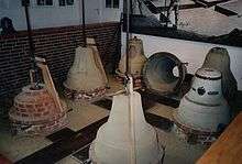
Gescher is a municipality in the district of Borken, in North Rhine-Westphalia, Germany. It is located near the border with the Netherlands. It is most often known for its bell work, and it includes a Museum of Bells.
Geography
Gescher is surrounded by farming communities and can be seen as more of a rural town.
Farming Communities and Suburbs
Farming Communities and suburbs belonging to Gescher include:
- Harwick
- Estern
- Büren
- Tungerloh-Capellen
- Tungerloh-Pröbsting
- Hochmoor
Location
Gescher is located in the western half of the Regierungsbezirk, Münsterland. It finds itself within the District of Borken, just to the south of Stadtlohn. To the east lies the District of Coesfeld, and the Dutch border can be found to the west.
The river, Berkel runs through Gescher and used to be used extensively to deliver goods between Dutch towns and Münster.
History
The early history of Gescher starts as a connecting stop on a postal route running from Muenster to the Netherlands. In 1570, Gescher suffered an enormous village-wide fire that destroyed the entire town. During the time of reconstruction, many looters came over from the Netherlands to take advantage of the unfortunate situation. After the Second World War, Gescher was under the control of Mr. Ball and the British sovereignty in Germany. Gescher was under the authority of Kreis Coesfeld up until 1975 when Gescher was pulled into Kreis Borken.
Population Changes over the Years

|
|
|
Infrastructure
Transportation
Private
The Bundesautobahn 31 connects Gescher with the Ruhr Region and the North Sea.
The Bundesstrasse 525 connects Gescher with the Dutch border and Nottuln/Bundesautobahn 43.
Public
Bus
Westfalenbus operates a few scheduled bus services through Gescher:
| Line | Route |
|---|---|
| R51 | Coesfeld - Gescher – Hochmoor - Velen – Borken - Rhede - Bocholt |
| R61 | Vreden - Stadtlohn - Gescher - Hochmoor - Coesfeld |
| 776 | Ahaus - Gescher - Hochmoor |
| N7 | Stadtlohn - Gescher - Rosendahl - Billerbeck - Havixbeck - Münster |
Rail
Up until 1985, Gescher was on the railroad offering services between Empel and Muenster. The old train station building can still be seen on the southside of Gescher.
Air
The closest general aviation airport is Stadtlohn-Vreden Airport, located about 15 kilometers from Gescher. The closest airport with scheduled commercial traffic is Münster Osnabrück International Airport, which is located about 50 kilometers away from Gescher. A way bigger alternative is the Düsseldorf Airport, which is located about 85 kilometers from Gescher.
Sons and daughters of the city
- Heinrich Hörnemann (1906-1977), farmer and German politician (CDU), Member of Bundestag 1961-1969
- Peter Schmidt (born 1944), German writer, multiple recipient (first and second place) of the Deutscher Krimi Preis
- August Wessing (1880-1945), Catholic clergyman and NS victim, died in Dachau concentration camp
Photos


References
- ↑ "Amtliche Bevölkerungszahlen". Landesbetrieb Information und Technik NRW (in German). 18 July 2016.
External links
- Official site (German)
Towns and municipalities in Borken (district) | ||
|---|---|---|