Münster (region)
| Münster | |
|---|---|
| Regierungsbezirk | |
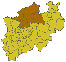 Map of North Rhine-Westphalia highlighting the Regierungsbezirk of Münster | |
| Country | Germany |
| State | North Rhine-Westphalia |
| Region seat | Münster |
| Area | |
| • Total | 6,904.93 km2 (2,666.01 sq mi) |
| Population (31 December 2015)[1] | |
| • Total | 2,614,229 |
| • Density | 380/km2 (980/sq mi) |
| Website | bezreg-muenster.nrw.de |
Münster is one of the five Regierungsbezirks of North Rhine-Westphalia, Germany, located in the north of the state, and named after the capital city of Münster. It includes the area which in medieval times was known as the Dreingau.
Regierungsbezirk Münster mostly covers rural lands of the Münsterland which is famous for its castles, e.g. Castle Nordkirchen and Castle Ahaus. The region offers more the 100 castles, all linked up by the bike path 100 Schlösser Route.
The three southern municipalities are part of the Ruhrgebiet, densely populated and still offer a wide range of industry. Besides that this area is mostly as green as the rest of the Münsterland and historically a part of the landscape.
The history of the Regierungsbezirk dates back to 1815, when it was one of the original 25 Regierungsbezirke created as a subdivision of the provinces of Prussia. The last reorganization of the districts was done in 1975, when the number of districts was reduced from 10 to 5, and the number of district-free cities from six to three.
| Kreise (districts) |
Kreisfreie Städte (district-free towns) |
|---|---|
Climate
The climate is mainly maritime, influenced by the recently deteriorating gulf stream.
Temperatures above 30 °C during the summer were rare until the 80s of the 20th century. Recently some summer months got more hot and dry or cool and wet with an increased abundance of extreme weather.
In winter time temperatures deep frost below -10°C occurs especially in times of Berlin Phenomenon and is rare in years without. Long time average temperatures about 1°C in January and February mean, that frost is quite common.
Traffic
A popular way to explore the Münsterland is by bicycle. The mostly flat landscape with its architectural and cultural gems invites cycling, both ambitious on-road riding (e.g. the Münsterland Giro race) and relaxed tours on small rural roads and Pättkes (minor paths, some are even unpaved). Embedded in a 4,500 km long network of cycle paths are not only the most popular themed routes, but also many small and large delightful tours and round courses through the region. Some infrastructure for cyclists with Bed & Bike farms, navigation systems, and service-stations make Münsterland a fine cycling area.
The city of Münster itself is crammed with bikes and on a daily basis cyclists face traffic congestion, bike theft, parking problems and the like.[2][3][4]
The road system is well-maintained and several highways offer fast access to nearly all areas.
In those areas where railroads haven't been closed down by the 1980s, frequent and fast service is offered. One streetcar system has survived in the city of Gelsenkirchen and many other towns and cities offer a fair bus network. Rural areas are connected by bus, too. The service is tied to demand and rather poor in very remote places.
The Münsterland can be explored by boat on some canals, e.g. the Dortmund–Ems Canal and Wesel–Datteln Canal. They connect the area to the harbours in Duisburg and Münster, the German coast and the rest of the German waterway system.
Landmarks
- Nordkirchen Castle - the most important castle, also called "Westphalian Versailles"
- Ahaus Castle
- Münster Cathedral
- St. Lambertus Cathedral
- Lembeck Castle
- Westerwinkel Castle
- Steinfurt Castle
- Gerleve Abbey
- House of Rüschhaus
- Horst Castle
- Hülshoff Castle - birthplace of Annette von Droste-Hülshoff
- The Industrial Heritage Trail - big part of this collection of monuments originated by the industrial revolution is sited in the southern half of this area
References
- ↑ "Amtliche Bevölkerungszahlen". Landesbetrieb Information und Technik NRW (in German). 18 July 2016.
- ↑ http://www.thieme.de/viamedici/studienort_muenster/freizeit/fahrrad-studie.html
- ↑ http://www.focus.de/auto/news/fahrraddiebstahl-drahtlos-in-muenster_aid_608772.html
- ↑ http://www.muenster.de/stadt/stadtplanung/radverkehr_radlager-stubengasse.html
External links
| Wikivoyage has a travel guide for Münsterland. |
Administrative regions (Regierungsbezirk) in North Rhine-Westphalia | |||
|---|---|---|---|
Coordinates: 52°00′N 7°30′E / 52.0°N 7.5°E