Daughters of Jacob Bridge
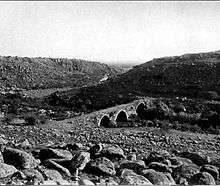
The Daughters of Jacob Bridge (Hebrew: גשר בנות יעקב, Gesher Bnot Ya'akov) is a site on the upper Jordan River. It has the last good ford at the southern end of the Hula Basin before the Jordan gets squeezed between the Korazim block and the Golan Heights, and has thus been a crossing point for thousands of years. The name Jacob's Ford arose during the Crusades and is still in use, mostly in English. The bridge was the best-known medieval bridge in Palestine, and was destroyed during the draining of Lake Hula by the PLDC.[1][2][3]
The bridges built here in the past have led to the site's Arabic name, Jisr Banât Ya'qūb (Arabic: جسر بنات يعقوب),[4] lit. "Daughters of Jacob Bridge", translated to Hebrew as Gesher Bnot Ya'akov, the name under which it is known today in Israel. The Hebrew name, written Gesher Benot Ya'aqov and abbreviated as GBY, is how the very important prehistoric archaeological site is known to the academic world. The modern bridge is part of Highway 91 and straddles the border between Israel and the Israeli-occupied portion of the Golan Heights. It is of strategic military significance as it is one of the few fixed crossing points over the upper Jordan River which enable access from the Golan Heights to the Upper Galilee.
Prehistoric remains at the site, analysed by archaeologists from Germany, the United States and the Hebrew University of Jerusalem, provided evidence that Lower Paleolithic hominins lived on the shore of a large lake (which was predecessor to and much larger than today's Hula Lake) and manufactured stone tools, butchered animals, gathered plant materials and probably controlled fire as early as 790,000 years ago.[5][6]
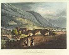
The caravan route from China to Morocco via Mesopotamia and Egypt used this crossing as part of the ancient Via Maris, which has been strategically important to Egyptian, Assyrian, Hittite, Jew, Saracen Arab, Crusader knight, and Ottoman Janissary, who had all crossed the river at this place.[7][8] The Crusaders built a castle overlooking the ford which threatened Damascus and was promptly attacked and destroyed by Saladin in 1179. The old arched stone bridge had marked the northern limit of Napoleon's advance in 1799.[7][8]
History and archaeology

Prehistory
Archaeological excavations at the prehistoric Gesher Benot Ya'aqov site (GBY) have revealed evidence of human habitation in the area, from as early as 750,000 years ago.[9] Archaeologists from the Hebrew University of Jerusalem claim that the site provides evidence of "advanced human behavior" half a million years earlier than has previously been estimated as possible. Their report describes a layer at the site belonging to the Acheulian (a culture dating to the Lower Palaeolithic, at the very beginning of the Stone Age), where numerous stone tools, animal bones and plant remains have been found.[10] According to the archaeologists Paul Pettitt and Mark White, the site has produced the earliest widely accepted evidence for the use of fire, dated approximately 790,000 years ago.[11]
Crusader and Ayyubid Period
Jacob's Ford was a key river crossing point and major trade route between Acre and Damascus.[12] It was utilized by Christian Palestine and Seljuk Syria as a major intersection between the two civilizations, making it strategically important. When Humphrey II of Toron was besieged in the city of Baniyas in 1157, King Baldwin III of Jerusalem was able to break the siege, only to be ambushed at Jacob's Ford in June of that year.[13]
Later in the twelfth century, Baldwin IV of Jerusalem and Saladin continually contested the area around Jacob's Ford. Baldwin allowed the Templars to build a castle overlooking Jacob's Ford and thus commanding the road from Quneitra to Tiberias.[14] On 23 August 1179, Saladin besieged and destroyed the unfinished fortification, known as the castle of Vadum Iacob or Chastellet.
Modern era
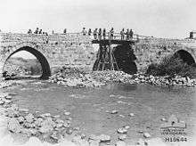
Another battle was fought there on 27 September 1918 during the Palestine Campaign of World War I, at the beginning of the pursuit by the British Army of the retreating remnants of the Ottoman Yildirim Army Group towards Damascus. The bridge was destroyed by the Turkish forces, but was rebuilt by ANZAC sappers.
On the "Night of the Bridges" between 16 and 17 June 1946, the bridge was again destroyed by the Jewish Haganah. The Syrians captured the bridge on June 11, 1948, during the 1948 Palestine war, but later withdrew as a result of the 1949 Armistice Agreements between Israel and Syria. After the war, the bridge was in the central demilitarised zone established by the armistice agreement.
In 1953, the site was chosen as the original location for the water intake of Israel's National Water Carrier project, but after US pressure the intake was moved downstream to the Sea of Galilee at Eshed Kinrot,[15] which later became known as the Sapir Pumping Station at Tel Kinrot/Tell el-'Oreimeh.
During the Six Day War, an Israeli paratrooper brigade captured the area and the Israeli Combat Engineering Corps constructed a Bailey bridge. In the Yom Kippur War, Syrian forces approached the vicinity of the bridge but did not cross it.
By 2007 there were two Bailey bridges employed at the site, one for traffic from east to west and the other for the opposite direction. However, in 2007 a modern concrete span was completed and as a consequence one of the Bailey bridges was dismantled and the other left intact for use on an emergency basis.
References
- ↑ Petersen, A., MEDIEVAL BRIDGES OF PALESTINE
- ↑ Roza El-Eini (23 November 2004). Mandated Landscape: British Imperial Rule in Palestine 1929-1948. Routledge. pp. 276–. ISBN 978-1-135-77240-6.
- ↑ Sandra M. Sufian (15 November 2008). Healing the Land and the Nation: Malaria and the Zionist Project in Palestine, 1920-1947. University of Chicago Press. pp. 165–. ISBN 978-0-226-77938-6.
- ↑ Sharon, 1999, p. 41
- ↑ Dig site shows distinct living spaces in early Stone Age
- ↑ http://archaeology.about.com/od/gterms/g/gesher_benot.htm
- 1 2 Preston, R. M. P. (1921). The Desert Mounted Corps: An Account of the Cavalry Operations in Palestine and Syria 1917–1918. London: Constable & Co. p. 261. OCLC 3900439.
- 1 2 Hamilton, Jill Duchess of Hamilton (2002). First to Damascus: The Story of the Australian Light Horse and Lawrence of Arabia. Roseville: Kangaroo Press. p. 158. OCLC 248935397.
- ↑ Evidence found of early modern humans (January 5, 2010) in Israel 21c Innovation News Service Retrieved 2010-01-05
- ↑ Evidence of advanced human life half a million years earlier than previously thought (Dec 22, 2009) in The Jerusalem Post Retrieved 2010-01-05
- ↑ Pettitt, Paul; White, Mark (2012). The British Palaeolithic: Human Societies at the Edge of the Pleistocene World. Abingdon, UK: Routledge. p. 194. ISBN 978-0-415-67455-3.
- ↑ Alan V. Murray, ed. (2006), The Crusades: An Encyclopaedia, ISBN 1-57607-862-0 p 649.
- ↑ Richard, Jean (1999) The Crusades c.1071-c.1291 Cambridge University press ISBN 0-521-62566-1 pp 175-176
- ↑ Payne, Robert (1998) The Crusades: A History Wordsworth Editions, ISBN 1-85326-689-2 p 188
- ↑ Sosland, Jeffrey (2007) Cooperating Rivals: The Riparian Politics of the Jordan River Basin SUNY Press, ISBN 0-7914-7201-9 p 70
Bibliography
- Murray, Alan V. editor. (2006), The Crusades: An Encyclopaedia, ISBN 1-57607-862-0
- Payne, Robert (1998) The Crusades: A History Wordsworth Editions, ISBN 1-85326-689-2
- Richard, Jean (1999) The Crusades c.1071-c.1291 Cambridge University press ISBN 0-521-62566-1
- Sharon, Moshe (1999). Corpus Inscriptionum Arabicarum Palaestinae, B-C. 2. BRILL. ISBN 90-04-11083-6.
External links
| Wikimedia Commons has media related to Bnot Ya'akov Bridge. |
- Bridge at Jisr Banat Ya'qub, 12th-century bridge pictured early 20th century.
- 80th Brigade's Battles in the Six-Day War. Paratroopers Brigade website. (Hebrew)
- Bridge Destruction During the Night of the Bridges (Hebrew)
- Gesher Benot Ya'aqov - an Introduction.
Coordinates: 33°0′37.02″N 35°37′41.83″E / 33.0102833°N 35.6282861°E