Gilf Kebir
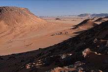
Gilf Kebir (جلف كبير) (var. Gilf al-Kebir, Jilf al Kabir) is a plateau in the New Valley Governorate of the remote southwest corner of Egypt, and southeast Libya. Its name translates as "the Great Barrier". This 7770-square-kilometre sandstone plateau, roughly the size of Puerto Rico, rises 300m from the Libyan Desert floor.
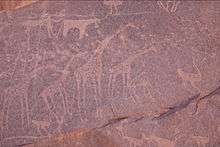
The name Gilf Kebir was given to the plateau by Prince Kamal el Dine Hussein in 1925, as it had no local name.[1] It is known for its rugged beauty, remoteness, geological interest, and the dramatic cliff paintings-pictographs and rock carvings-petroglyphs which depict an earlier era of abundant animal life and human habitation.
Geography and climate
The Uweinat mountain range at the very south of the plateau extends from Egypt into Libya and Sudan.
Climate
Gilf Kebir Plateau lies in the heart of the eastern part of the vast Sahara Desert, and, thus, gets some of the most extreme climates on Earth. This is the driest place on the planet, not only because the area is totally rainless (the annual average rainfall amount hardly reaches 0.1 mm) but also because the geological aridity index/dryness ratio is over 200, which means that the solar energy received at the ground evaporate 200 times the amount of precipitation received.[2] Rainfall may fall every twenty years in Gilf Kebir.
| Climate data for Gilf Kebir Plateau | |||||||||||||
|---|---|---|---|---|---|---|---|---|---|---|---|---|---|
| Month | Jan | Feb | Mar | Apr | May | Jun | Jul | Aug | Sep | Oct | Nov | Dec | Year |
| Average high °C (°F) | 20.8 (69.4) |
23.6 (74.5) |
27.8 (82) |
33.8 (92.8) |
36.6 (97.9) |
38.3 (100.9) |
38.7 (101.7) |
38.6 (101.5) |
37.2 (99) |
32.3 (90.1) |
26.3 (79.3) |
22.1 (71.8) |
31.34 (88.41) |
| Average low °C (°F) | 7.7 (45.9) |
10 (50) |
12.4 (54.3) |
18.4 (65.1) |
22.2 (72) |
24.9 (76.8) |
26.1 (79) |
26.3 (79.3) |
24.2 (75.6) |
19.2 (66.6) |
13.2 (55.8) |
8.7 (47.7) |
17.77 (64.01) |
| Source: Storm247.com[3] | |||||||||||||
Wadis
The plateau is crisscrossed by Wadis (dry, seasonal riverbeds). These include:
- Wadi Akhdar وادى الاخضر
- Wadi Bakht وادى البخت
- Wadi Dayiq وادى الضيق
- Wadi Firaq وادى فراق
- Wadi Gazayir وادى الجزائر
- Wadi Maftuh وادى مفتوح
- Wadi Mashi وادى مشى
- Wadi Sura وادي صورة
- Wadi Wassa وادى وسع
- Wadi Hamra وادي حمراء
History
Petroglyphs
The Gilf Kebir is known for its prehistoric Neolithic petroglyphs
- Karkur Talh and Karkur Murr: major eastern valleys of the Uweinat contain one of the richest concentrations of rock art in the whole Sahara.
- Western Uweinat: Shelters under the huge granite boulders in the western Uweinat contain numerous paintings, including the famous sites of Ain Doua.
- Jebel Arkenu, Jebel Kissu & Yerguehda Hill, the lesser granite massifs around Uweinat have many smaller sites.
- Mogharet el Kantara in the southern Gilf Kebir contains only one known rock art site, a cave discovered by Shaw & party in 1936.
- Wadi Sura in the southwestern Gilf Kebir: the "Cave of Swimmers", discovered by the Hungarian Count László Almásy (The English Patient), plus many other paintings nearby.
- The North-western half of the Gilf Kebir aside from Wadi Sura has only a few scattered engravings, of an apparently very ancient age.
- In January 2003, Zarzora Expeditions and Jacopo Foggini independently announced the discovery of a major new rock art site in the Western Gilf Kebir (Foggini-Mestekawi Cave).
Saharan rock art has been found to resemble art of Nile valleys. The Saharan area was more wet until mid-Holocene or about 4000 BC, when the monsoon retreated southwards, forcing humans to migrate. Some retreated eastward to the Nile valley, taking with them their beliefs and influencing Egyptian art.[4][5][6]
20th century exploration
The hills of the Gilf Kebir were first seen from a distance by European explorers in 1910 - with W. J. Harding-King in 1910 and 1911, and Dr. Ball and Lieutenant Moore in 1918. The high southern part of the plateau was sighted for the first time by Prince Kamal el Dine Hussein in 1925, and on another expedition in the following year he fixed the eastern escarpment of the plateau and first realised the true size of the plateau. In 1930 an expedition headed by Ralph Alger Bagnold followed the same route. In the winter of 1930-1 P. A. Clayton surveyed some of the area.
The western side of the Gilf Kebir was explored in 1932 by the Clayton-Almásy Expedition, headed by Sir Robert East Clayton and Count László E. Almásy, and accompanied by Patrick A. Clayton, Squadron Leader H. W. G. J. Penderel, three Arabian car drivers and a cook. The expedition explored the area by Gypsy Moth plane, by car and on foot.
WWII archeology
The plateau was the site for various British logistical operations during the Second World War, and due to the extremely dry conditions and lack of population, remains of this occupation are often found intact. A large airbase, including huge navigation arrows laid out in army petrol cans, can still be seen.
It was also the site of the recent discovery of a bag which had been lost in the Second World War by a dispatch rider (Alec Ross) of the Long Range Desert Group, part of the British Army. This contained the rider's personal letters and photographs, and had been well preserved.
Literary setting
The Gilf Kebir is the setting for part of Michael Ondaatje's novel The English Patient. It also plays an important role in Paul Sussman's The Hidden Oasis.
Curiosity
In 2006, Gilf Kebir Desert was the site of an extreme sports record from Italian runner Stefano Miglietti. On 14 December 2006, Miglietti crossed the desert by foot, taking only 3 days and 5 hours to cover the full 340 km trail, running at an average speed of 9 km/h. Miglietti started from Wadi Mashi and arrived at Silica Glass, a desert close to the Gilf Kebir desert.
See also
References
- ↑ F. J. R. R., "A Reconnaissance of the Gilf Kebir by the Late Sir Robert Clayton East Clayton" and P. A. Clayton, "The Western Side of the Gilf Kebir" Geographical Journal 81, 249-254 and 254-259, (1933)
- ↑ https://books.google.com/books?id=uL86PAq-eHMC&pg=PA550&lpg=PA550&dq=Gilf+Kebir+driest&source=bl&ots=t_ws9aQt4E&sig=RGPjeZjEI7DXm27vEWLgJYNhrZM&hl=en&sa=X&ved=0ahUKEwiBtNiD263KAhVHcBoKHaCnAkcQ6AEIHjAH#v=onepage&q=Gilf%20Kebir%20driest&f=false
- ↑ "Weather for Gilf Kebir Plateau, Egypt". Storm247.com. Retrieved 22 June 2013.
- ↑ Jean-Loïc Le Quellec and Pauline and Philippe de Flers (2006). "Prehistoric swimmers in the Sahara." Arts & Culture 46-61.
- ↑ Julien d'Huy (2009). "New evidence for a closeness between the Abu Ra´s shelter (Eastern Sahara) and Egyptian beliefs." Sahara 20: 125-126 and Julien d'Huy and Jean-Loïc Le Quellec (2009)
- ↑ Julien d'Huy and Jean-Loïc Le Quellec (2009)"From the Sahara to the Nile: the low representation of dangerous animals in the rock art of the Libyan desert could be linked to the fear of their animation", or , translation by Geoffrey Kolbe from "Du Sahara au Nil. La faible représentation d'animaux dangereux dans l'art rupestre du désert Libyque pourrait être lié à la crainte de leur représentation." Cahiers de l'AARS 13: 85-98, or .
- Legends haunt remote nomad's land, Matthew Davis, BBC. 25 September 2008.
- 'WWII Army Bag is found in Desert'
- Libyan Rock Art Documentation Project
External links
Coordinates: 23°26′29″N 25°50′23″E / 23.44139°N 25.83972°E