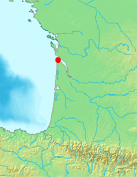
Gironde estuary
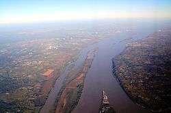
The Gironde is a navigable estuary (often falsely referred to as a river), in southwest France and is formed from the meeting of the rivers Dordogne and Garonne just downstream of the centre of Bordeaux. Covering around 635 km2 (245 sq mi), it is the largest estuary in western Europe.[1]
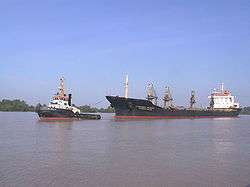
The Gironde is approximately 80 km (50 mi) long and 3–11 km (2–7 miles) wide and the French département Gironde is named after it. The Gironde is subject to very strong tidal currents and great care is needed when navigating the estuary by any size or type of boat.
Second World War
In December 1942, during the Second World War, Operation Frankton took place with the goal of destroying shipping moored at the docks in Bordeaux. These German blockade runners were causing havoc in the Western Approaches. The raid was carried out by a small unit of Royal Marines known as the Royal Marines Boom Patrol Detachment (RMBPD), part of Combined Operations, led by Herbert 'Blondie' Hasler.
Islands of the Gironde
Within the estuary between the Pointe de Grave at the seaward end and the Bec d'Ambès are a series of small islands.
The Île de Patiras is 200 ha in size with a lighthouse to aid navigation in the estuary. Vines and maize are grown there.
The Île Sans-Pain and Île Bouchaud are now virtually joined due to progressive silting and are referred to as the Ile Nouvelle. They total about 265 ha and are owned by the Conservatoire du Littoral and managed by the Department of the Gironde.
The Île Paté is about 13 ha and in 2006 was privately owned. The island has a historic fort built between 1685 and 1693 as part of the national fortification program masterminded by Vauban. The building is oval in shape, about 12 metres high and was originally equipped with about 30 cannon. Fort Paté, together with Fort Médoc and the ancient citadelle of Blaye, defended the estuary and Bordeaux. During the French Revolution the fort was used as a prison for priests.
In 2006, the Conseil General decided to make the island a ZPENS (zone de pre-emption espace naturel sensible). ZPENS status protects the island from development. If the owner wishes to sell the island then the Department has a pre-emptive right. After two months the Conservatoire National du Littoral has the next pre-emptive right and then after another 2 months the town of Blaye has a final pre-emptive right to acquire the island.
The Île Verte, Île du Nord and Île Cazeau comprise about 800 ha and because of their natural state provide a fine stopping off place for migrating birds.
The Île Margaux is 25 ha and in 2005 had 14 ha devoted to vines and is part of the world famous Médoc wine region.
| Wikimedia Commons has media related to Gironde estuary. |
References
- The information relating to the protected status of Île Paté and the general information relating to the other islands is public domain information which was summarised as part of an article in the regional 'Sud Ouest' newspaper dated 3 October 2006.
- ↑ (C) Parc naturel marin sur l'estuaire de Gironde et sur les Pertuis Charentais : l'étude est lancée Agence des aires marines protégées/French Marine Protected Areas Agency, published 2008-07-25, accessed 2011-03-30
Coordinates: 45°16′01″N 0°42′39″W / 45.26694°N 0.71083°W