Givatayim
Givatayim
| |||
|---|---|---|---|
| Hebrew transcription(s) | |||
| • ISO 259 | Gibˁataym | ||
| • Also spelled |
Givatayim (official) Giv'atayim, Givataim (unofficial) | ||
|
Panorama of Givatayim | |||
| |||
 Givatayim | |||
| Coordinates: 32°04′11″N 34°48′42″E / 32.06972°N 34.81167°ECoordinates: 32°04′11″N 34°48′42″E / 32.06972°N 34.81167°E | |||
| District | Tel Aviv | ||
| Founded | 1922 | ||
| Government | |||
| • Type | City (from 1959) | ||
| • Mayor | Ran Kunik | ||
| Area | |||
| • Total | 3,211 dunams (3.211 km2 or 1.240 sq mi) | ||
| Population (2015)[1] | |||
| • Total | 57,508 | ||
| Name meaning | Two hills | ||
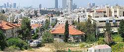

Givatayim (Hebrew: גִּבְעָתַיִם, lit. "two hills"; Arabic: جفعاتايم) is a city in Israel east of Tel Aviv. It is part of the metropolitan area known as Gush Dan. Givatayim was established in 1922 by pioneers of the Second Aliyah. In 2015 it had a population of 57,508.
The name of the city comes from the "two hills" on which it was established: Borochov Hill and Kozlovsky Hill. Kozlovsky is the highest hill in the Gush Dan region at 85 meters above sea level. The city expanded in the 1930s so that today it is actually situated on 4 hills, Borochov, Kozlovsky, the railroad workers (poalei harakevet), and Rambam Hill.
History
| Historical population | ||
|---|---|---|
| Year | Pop. | ±% |
| 1948 | 9,600 | — |
| 1955 | 19,800 | +106.2% |
| 1961 | 30,900 | +56.1% |
| 1972 | 48,600 | +57.3% |
| 1983 | 46,700 | −3.9% |
| 1995 | 49,000 | +4.9% |
| 2008 | 52,100 | +6.3% |
| 2010 | 54,000 | +3.6% |
| 2011 | 54,700 | +1.3% |
| Source: | ||

Archaeological ruins date settlement on the site of what is now Givatayim back to the Calcolithic period. The modern town was founded on April 2, 1922 by a group of 22 Second Aliyah pioneers led by David Schneiderman. The group purchased 300 dunams (300,000 square metres (3,200,000 sq ft)) of land on the outskirts of Tel Aviv that became the Borochov neighborhood, the first workers' neighborhood in the country. It was named for Dov Ber Borochov, founder of the Poalei Zion workers' party. Later, another 70 families joined the group, receiving smaller plots. The land was purchased with their private savings, but was voluntarily transferred to the Jewish National Fund, which organized Jewish settlement at the time, in keeping with the pioneers' socialist beliefs.[3]
Givatayim is credited for a number of breakthroughs in the early Jewish settlement movement, including establishing the first cooperative grocery store (Tzarkhaniya) [4] that still functioned in the same location into the 1980s.
Over time, more neighborhoods developed: Sheinkin (1936), Givat Rambam (1933), Kiryat Yosef (1934), and Arlozorov (1936). All these neighborhoods were merged to form a local council in August 1942. Givatayim was declared a city in 1959.
Geography
Givatayim is located east of Tel Aviv, and is bordered on the north and east by Ramat Gan.
Education
Givatayim has 41 kindergartens, 9 elementary schools and 4 high schools. The city has Israel's highest rate of secondary school matriculation. and the highest rate of "Bagrut" rate in the Tel-Aviv metropolitan area. Mayor Ruven Ben-Shachar initiated a special high school exam assistance program that after 3 years resulted in an 11% increase of high school test results in 2010.
Urban development
Eurocom Tower, under construction in Givatayim, is a 70-story skyscraper which will be Israel's tallest building upon completion. It is part of a complex that includes four apartment towers and a 50-story office building. A large square will connect to surrounding areas with bridges and underground passes. The complex will be located near Ramat Gan and its Diamond Exchange District.[5]
In addition to Eurocom Tower, other high-rise projects are planned for the city. According to former Givatayim mayor Reuven Ben-Shahar, the municipality's policy is to promote high-rise construction on the city's outer edges, while preserving the fabric of residential neighborhoods deeper within the city, including the city center.[5]
Mayors
- Shimon Ben-Zvi (1941–65)
- Kuba Kraizman (1965–78)
- Yizhak Yaron (1978–93)
- Efi (Ephraim) Schtenzler (1993–2006)
- Iris Avram, replaced the previous mayor due to his early resignation after he became the chairman of KKL - the Jewish National Fund (2006–07)
- Reuven Ben-Shahar (2007–13)
- Ran Konik (2013–present)
Reuven Ben-Shahar was the first candidate from Kadima that won a city election and the first mayor in Givatayim that was not from the Israeli Labor Party.
Notable residents
- Dvora Bochman, artist
- Oded Kattash, basketball player and coach
- Mickey Rosenthal, Labor Party Member of the Knesset
International relations
Twin towns — sister cities
Givatayim is twinned with:
 Sfântu Gheorghe, Romania
- Oradea, Romania
- Arad, Romania
 Chattanooga, Tennessee
 Harbin, China[6]
 Vác, Hungary
 Esslingen am Neckar, Germany
References
- ↑ "List of localities, in Alphabetical order" (PDF). Israel Central Bureau of Statistics. Retrieved 16 October 2016.
- ↑ "Statistical Abstract of Israel 2012 - No. 63 Subject 2 - Table No. 15". .cbs.gov.il. Retrieved 2013-08-08.
- ↑ Sadeh, Shuki (2008-07-10). "Land day". Haaretz. Retrieved 2008-07-22.
- ↑ "Givatayim - Official Site (Hebrew)". givatayim.muni.il. Retrieved 2009-01-08.
- 1 2 Lior, Ilan (2012-02-03). "Givatayim getting Israel's tallest skyscraper - Israel News | Haaretz Daily Newspaper". Haaretz.com. Retrieved 2013-03-26.
- ↑ "Givatayim". Harbin.gov.cn. 2007-03-15. Retrieved 2008-10-18.
External links
| Cities | ||
|---|---|---|
| Local councils | ||
| ||