Glebe Island
Glebe Island was a major port facility in Sydney Harbour and, in association with the adjacent White Bay facility, was the primary receiving venue for imported cars and dry bulk goods in the region until 2008.[1] It is surrounded by White, Johnstons, and Rozelle Bays. Whilst retaining its original title as an "island", it has long been infilled to the shoreline of the suburb of Rozelle and connected by the Glebe Island Bridge (and its replacement the Anzac Bridge) to Pyrmont.
History
Abattoirs and bridges
The rocky outcrop known as Glebe Island was originally accessible from the Balmain shoreline only at low tide, until a causeway was laid in the 1840s. Surveyor William Wells created a subdivision for the Balmain end of the island in 1841, with four intended streets and six sections containing a total of 86 lots.[2] The subdivision did not eventuate.
In 1850–1854, Colonial Architect Edmund Blacket designed stone buildings for a public abattoir on the island. According to Joan Kerr, Blacket's chosen architecture was Norman in inspiration – round-headed openings and simple decoration. Kerr states that the abattoir was almost certainly based on an American design.[3]
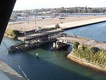
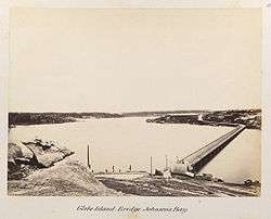
On 7 September 1860, Balmain Council resolved to approach the owners of the unsold parts of the Balmain Estate for a grant of land to build a road to the island.[4] The Pyrmont Bridge Company built a low-level timber-framed bridge that connected the island to Pyrmont, and thus to the city, in 1862.[5]
The abattoirs featured prominently in the 1882 Royal Commission into noxious and offensive trades, instigated by complaints from Balmain and Glebe Point residents.[6] The commission found that in 1882, 524,415 sheep, 69,991 cattle, 31,269 pigs and 8,348 calves were slaughtered there.
On 28 June 1903 the new bridge to Pyrmont, designed by Percy Allan, Assistant Engineer for Bridges in the NSW Department of Public Works, opened.[7] Like the ground-breaking Pyrmont Bridge being built at the same time, the second Glebe Island Bridge was a swing bridge swivelling on a massive central stone pivot-pier with timber-trussed side spans. The two bridges "are among the structures standing as monuments" to Allan's skill.[8] Under the Local Government Act 1906, the 14-hectare (34-acre) Glebe Island was added to the Municipality of Balmain.[9]
Wharves and silos
From 1912, the Sydney Harbour Trust (later Maritime Services Board) planned broadside wharfage at Balmain East and along the southern shore of Balmain, including Glebe Island.[10] Also in 1912 the Metropolitan Meat Industry Board resolved to abolish the abattoirs and build a new facility at Homebush.[11] By 1915 Robert Saunders, the Pyrmont quarry master, had been commissioned to level the island to make it suitable for wharves. Saunders's firm dumped a great quantity of excavated ballast at the eastern end of the island for wharfage. Many cubic feet of quality dimension stone, however, were carefully cut away and almost certainly used for construction projects. Some 250 of Saunders's men were still working on the island in 1920.[11]
Glebe Island was an early success for the Harbour trust. Wharves were built on three sides of the levelled rocky outcrop from 1912.[12] The reconstructed fourth side was attached to the Rozelle shoreline as part of the extensive reclamation of Rozelle Bay and White Bay which had begun in the 1890s.[13]
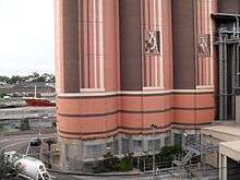
Glebe Island became the site of a grain elevator and tall concrete silos, operated from 1921 by the Grain Elevators Board of NSW.[14] The 1958 Australian Encyclopaedia records that the bulk wheat terminal had a capacity of 7,500,000 bushels (202,500 tonnes).[15] During World War II much of the island was commandeered for the main United States army depot in Sydney.
Industry to tourism
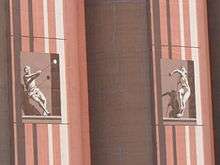
Bulk handling of grain continued until 1990 when the wheat terminal was transferred to Port Kembla and the wharfage remodelled for containerised cargo.[14] Some silos were demolished, while from 1991 Australian Cement (now Cement Australia) used 16 of them as a bulk cement terminal. These are now heritage-listed. In the 1990s a high-level, cable-stayed, reinforced concrete six-lane bridge spanning 345 metres between two 120-metre towers was built above the older Allan-designed Glebe Island Bridge. Named Anzac Bridge, the arterial structure opened on 3 December 1995. Until November 2008, the island was the Australian Amalgamated Terminals (AAT) facility for imported motor vehicles.
Discussions for rejuvenation of the now disused site are ongoing. In 2008 it was suggested by the Government of New South Wales that a tennis center could be created to host the Australian Open tournament after Melbourne's existing contract expires in 2016.[16] This plan was short-lived and in 2009 it was announced that White Bay would be renovated at the same time as the Barangaroo development to become a cruise ship terminal to alleviate pressure on the existing facilities at Darling Harbour and Circular Quay. This is a controversial decision with the local community due to largely to traffic concerns[17] and has been called a "good short term solution" by industry groups as most cruise ships currently being constructed would not be able to fit underneath the Sydney Harbour Bridge in order to reach the facility.[18] On New Year's Eve 2011-12, the large empty space, convenietly located with a good view of the Sydney Harbour Bridge fireworks, was used for a major televised concert with headliners Jamiroquai, Culture Club and Pet Shop Boys.[19]
In August 2013, construction began on an interim exhibition facility Sydney Exhibition Centre @ Glebe Island, which opened on 15 February 2014. The venue offers 20,000 square metres of permanent space for large trade and consumer exhibitions and will operate throughout the redevelopment of the Sydney Convention and Exhibition Centre.[20]
References
- ↑ Sydney Ports Corporation, viewed 24 December 2009.
- ↑ WH Wells, Plan of a Part of the Glebe Island Situated between Balmain, Pyrmont and The Glebe for Sale by Auction by Mr Stubbs on Monday 12 July 1841
- ↑ Kerr, Joan (1983). Our Great Victorian Architect, Edmund Thomas Blacket (1817-1883). Sydney: National Trust. pp. 74–75. ISBN 0-909723-17-6.
- ↑ Balmain Council Minutes, minute 218, 7 September 1860
- ↑ Select Committee on the Pyrmont Bridge Company Bill (amended)', NSW Legislative Assembly Votes and Proceedings, 1858, vol 2; Pyrmont Bridge Co – half-yearly meeting, NSW Government Gazette, 1863, p 1619
- ↑ "Report of the Royal Commission appointed on 20 November 1882, to inquire into the nature and operations of, and to classify noxious and offensive trades within the city of Sydney and its suburbs and to report generally on such trades; together with the Minutes of Evidence and Appendices ordered by the Council to be printed, 31 May 1863", Journal Legislative Council, NSW 1883, Second Session, vol 25, p 194. National Library of Australia Record number 2269259
- ↑ L. Coltheart and D. Fraser, Landmarks in Public Works: engineers and their works in New South Wales, 1884-1914, Hale and Iremonger, Sydney, 1987, p 72 ISBN 0-86806-296-0
- ↑ Corbett, Arthur (1979). "Allan, Percy (1861-1930)". Australian Dictionary of Biography. Canberra: Australian National University. Retrieved 27 December 2009.
- ↑ Souvenir to Commemorate the 50th Anniversary of the Incorporation of the Municipality of Balmain 1860-1910, p 35
- ↑ "The first 22 lots — an overview". Leichhardt Historical Journal. 14: 57. 1985. ISSN 0155-4840.
- 1 2 Irving, Robert (2006). Paradise Purgatory Hell Hole: The story of the Saunders sandstone quarries, Pyrmont. Singapore: Media Masters. p. 50. ISBN 981-05-5922-4.
- ↑ Proudfoot, Peter (1988). "The Extension of Maritime Activity in Sydney: Pyrmont, Glebe Island and Balmain 1890-1950". The Great Circle: the journal of the Australian Association for Maritime History. 10: 110–135. ISSN 0156-8698.
- ↑ Land and Property Information NSW, Central Mapping Authority Sheets U0945-32, U0945-33, note 33
- 1 2 Peninsula Observer: the Balmain Association Incorporated news sheet, number 210, February 1992
- ↑ "Ports and Harbours", Australian Encyclopaedia, Angus and Robertson, Sydney 1958, vol 7, p 211
- ↑ "Sydney plans Australian Open bid". BBC News. 11 October 2008. Retrieved 11 October 2008.
- ↑ ABC News online White Bay cruise ship opposition mounts, 29 January 2009. Accessed 14 January 2010.
- ↑ Tourism and Transport Forum Australia White Bay: Good short term solution, press release, 21 December 2009. Accessed 14 January 2010
- ↑ Murada, Lauren 15 November 2011, Inner West Courier: New Year's Eve concert on Glebe Island announced for the Sydney Resolution Concert Series (accessed 2 January 2012.
- ↑ "Darling Harbour Redevelopment". Sydney Convention and Exhibition Centre. Retrieved 19 September 2013.
written by Peter Reynolds, 2008 and licensed under CC by-sa. Imported on 24 December 2009.
External links
- AEG Ogden take over running of new temporary exhibition space http://www.eeaa.com.au/article.php?id=2102
- Reference and article (cc-by-sa) on Glebe Island in the Dictionary of Sydney
- Sydney Ports Corporation facilities description of Glebe Island and White Bay
- Leichhard Municipal Council Bays Precinct Consultation and White Bay Masterplan containing documents primarily from 2009.
- Sydney Exhibition Centre @ Glebe Island website
Islands in Sydney Harbour and on the Parramatta River | ||
|---|---|---|
| Sydney Harbour | 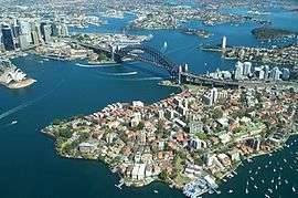 | |
| Parramatta River | ||
| Former Islands | ||
Coordinates: 33°52′01″S 151°11′02″E / 33.867°S 151.184°E