Glen O'Dee Hospital
| Glen O'Dee Hospital | |
|---|---|
| NHS Grampian | |
| Geography | |
| Location | Banchory, Aberdeenshire, Scotland, United Kingdom |
| Organisation | |
| Care system | Public NHS |
| Hospital type | Community |
| Services | |
| Emergency department | No Accident & Emergency |
| History | |
| Founded | 1900 |
| Links | |
| Website | NHS Grampian - Glen O'Dee Hospital - Banchory |
| Lists | Hospitals in Scotland |
Glen O' Dee Hospital is situated in the west end of Banchory, Aberdeenshire, Scotland. It is a community hospital that provides services for the population of Royal Deeside supported by the general practitioners from the local GP practices.
History
The original building was built in 1900[1] and started its life as Nordrach on Dee Hospital,[2] a sanctuary for tuberculosis patients.[3] When TB died down it served as a luxury hotel (when it became "Glen O' Dee"), but was taken over during the war to serve as a billet for troops. In 1955 it became a convalescent hospital.[4] It reprised its role in contagious diseases when the typhoid epidemic hit nearby Aberdeen in the 1960s, but its last use was as a residential home for the elderly. The original building closed in 1998, when a new purpose built building was built on the same site.
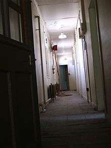
The original building has been featured on the BBC's Restoration programme, but it has sat empty and deteriorating since 1998.
The historic building was destroyed by fire on 14 October 2016, with police treating the incident as wilful fire-raising.[5]
External links
- Pictures of the decaying interior of the original building
- Aerial photo 1 of the derelict hospital taken in May 2015
- Aerial photo 2 of the derelict hospital taken in May 2015
References
- ↑ "Community hospitals: Glen O' Dee Hospital - Banchory". NHS Grampian. 8 March 2012. Retrieved 12 June 2014.
- ↑ "Nordrach-on-Dee Hospital". Dictionary of Scottish Architects. Retrieved 12 June 2014.
- ↑ "Glen O'Dee hospital". Banchory Group Practice. Retrieved 12 June 2014.
- ↑ "Anger as A-listed building is sold for luxury flats". The Scotsman. 7 October 2003. Retrieved 12 June 2014.
- ↑ "Historic Glen O'Dee hospital in Banchory destroyed by 'wilful' fire". BBC News. 14 October 2016.

Coordinates: 57°3′40″N 2°31′11″W / 57.06111°N 2.51972°W