Glenn Highway
| |
|---|---|
| Route information | |
| Length: | 179 mi[1] (288 km) |
| Tourist routes: |
|
| Major junctions | |
| West end: | Anchorage near Merrill Field |
| East end: |
|
| Highway system | |


The Glenn Highway (part of Alaska Route 1) is a highway in the U.S. state of Alaska, extending 179 miles (288 km) from Anchorage near Merrill Field to Glennallen on the Richardson Highway. The Tok Cut-Off is often considered part of the Glenn Highway, for a total length of 328 miles (528 km).
Route description
The longest stretch of freeway in Alaska runs mostly along the Glenn Highway, beginning in north Anchorage, continuing onto the Parks Highway at the interchange of the two roads, and ending in the city limits of Wasilla, for a total of approximately 38 miles (61 km). This 38-mile (61 km) portion of the Glenn Highway is the only road access to Anchorage for most of the state (with the exception of the Kenai Peninsula on the Seward Highway), and as such is the main traffic corridor for Anchorage's suburbs in the Chugiak-Eagle River and Mat-Su areas. The highest point on the highway is 3,332 feet (1,016 m) at Eureka Summit, which sits on the divide between the Chugach and Talkeetna mountain ranges.[2]
History
The highway originated as the Palmer Road in the 1930s, to reach the agricultural colony at Palmer. During World War II it was completed to Glennallen as part of a massive program of military road and base building that also resulted in the Alaska Highway,[3] and connected Anchorage to the continental highway system.[4]
It is named for Captain Edwin Glenn, leader of an 1898 U.S. Army expedition to find an Alaska route to the Klondike gold fields (the eventual Richardson Highway). The highway was paved in the 1950s.
Paleontology
The "Talkeetna Mountains Hadrosaur" specimen was discovered in 1994 in a quarry being excavated for road material.[5] That fall, excavation began, and was resumed in the summer of 1996.[5] The quarry is near the Glenn Highway, approximately 150 miles northeast of Anchorage.[6] This specimen was the first associated skeleton of an individual dinosaur discovered in all of Alaska.[7]
Major intersections
| County | Location | mi | km | Destinations | Notes |
|---|---|---|---|---|---|
| Municipality of Anchorage | 0 | 0.0 | Airport Heights Drive | Western terminus. Roadway continues west as 5th Avenue | |
| Bragaw Street | |||||
| Boniface Parkway | |||||
| Turpin Street | Eastbound exit and entrance | ||||
| Muldoon Road | |||||
| Arctic Valley Road | Eastbound exit and westbound entrance | ||||
| D Street | |||||
| Eagle River Loop Road | |||||
| Artillery Road | |||||
| Ekluntna Park Drive | |||||
| South Birchwood Loop Road | |||||
| Birchwood Loop Road | |||||
| Voyles Boulevard | |||||
| Lake Hill Drive | |||||
| Paradis Lane | No access westbound to Paradis Lane | ||||
| Old Glenn Highway | Eastbound entrance and exit | ||||
| Eklutna Village Road | |||||
| Old Glenn Highway | No access to Old Glenn Highway eastbound | ||||
| Matanuska-Susitna | Knik River | SFC James Bondsteel Bridge of Honor across the Knik River | |||
| Knik River Access | |||||
| Gateway | |||||
| Northern end of freeway | |||||
| Palmer | Palmer-Wasilla Highway | ||||
| Unorganized | Glennallen | 179 | 288 | ||
| 1.000 mi = 1.609 km; 1.000 km = 0.621 mi | |||||
Gallery
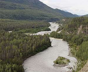 The Glenn Highway on the right side of the Matanuska River at mile 76 (km 123).
 Matanuska Glacier seen from the Glenn Highway at mile 102 (km 164)
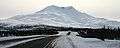 Gunsight Mountain and the Glenn Highway near mile 129 (km 208)
 Mount Drum and the Glenn Highway near mile 170 (km 274)
Footnotes
- ↑ Google (December 28, 2013). "Glenn Highway" (Map). Google Maps. Google. Retrieved December 28, 2013.
- ↑ The Milepost, 59th edition, pg. 322, ISBN 978-1-892154-21-7
- ↑ http://www.akhistorycourse.org/articles/article.php?artID=230
- ↑ http://www.alaska101.com/exploreAlaska/glennh/alaska_travel_glennh.htm
- 1 2 "Introduction," in Pasche and May (2001); page 220.
- ↑ "Location and Geologic Setting," in Pasche and May (2001); page 220.
- ↑ "Abstract," in Pasche and May (2001); page 219.
References
- Pasch, A. D., K. C. May. 2001. Taphonomy and paleoenvironment of hadrosaur (Dinosauria) from the Matanuska Formation (Turonian) in South-Central Alaska. In: Mesozoic Vertebrate Life. Ed.s Tanke, D. H., Carpenter, K., Skrepnick, M. W. Indiana University Press. Pages 219-236.
External links
![]() Media related to Glenn Highway at Wikimedia Commons
Media related to Glenn Highway at Wikimedia Commons