Wasilla, Alaska
| Wasilla, Alaska | ||
|---|---|---|
| City | ||
 | ||
| ||
 Location in Matanuska-Susitna Borough and the state of Alaska. | ||
 Wasilla, Alaska Location in Alaska | ||
| Coordinates: 61°34′54″N 149°27′9″W / 61.58167°N 149.45250°WCoordinates: 61°34′54″N 149°27′9″W / 61.58167°N 149.45250°W | ||
| Country | United States | |
| State | Alaska | |
| Borough | Matanuska-Susitna | |
| Incorporated | February 26, 1974[1] | |
| Government | ||
| • Mayor | Bert Cottle[2] | |
| • State senator | Charlie Huggins (R) | |
| • State rep. | Lynn Gattis (R) | |
| Area | ||
| • Total | 12.4 sq mi (32.2 km2) | |
| • Land | 11.7 sq mi (30.3 km2) | |
| • Water | 0.7 sq mi (1.8 km2) | |
| Elevation | 341 ft (104 m) | |
| Population (2010) | ||
| • Total | 7,831 Ranked 12th | |
| • Estimate (2013) | 8,621 | |
| • Density | 669.3/sq mi (258.4/km2) | |
| Time zone | Alaska (AKST) (UTC-9) | |
| • Summer (DST) | AKDT (UTC-8) | |
| ZIP codes | 99629, 99654, 99687 | |
| Area code | 907 | |
| FIPS code | 02-83080 | |
| GNIS feature ID | 1411788 | |
| Website | cityofwasilla.com | |

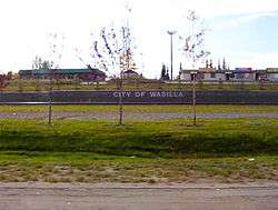
Wasilla is a city in Matanuska-Susitna Borough, United States and the sixth-largest city in Alaska. It is located on the northern point of Cook Inlet in the Matanuska-Susitna Valley of the southcentral part of the state. The city's population was 7,831 at the 2010 census. Estimates in 2013 put the population at roughly 8,621. Wasilla is the largest city in the borough and a part of the Anchorage metropolitan area, which had an estimated population of 396,142 in 2013.
Established at the intersection of the Alaska Railroad and Old Carle Wagon Road, the city prospered at the expense of the nearby mining town of Knik. Historically entrepreneurial, the economic base shifted in the 1970s from small-scale agriculture and recreation to support for workers employed in Anchorage or on Alaska's North Slope oilfields and related infrastructure. The George Parks Highway turned the town into a commuter suburb of Anchorage.[3] Several state and federal agencies have offices in Wasilla, including the Alaska Departments of Environmental Conservation, Labor and Divisions of Public Assistance, Social Services.
Wasilla gained international attention when Sarah Palin, who served as Wasilla's mayor before her election as Governor of Alaska, was chosen by John McCain as his vice-presidential running mate in the 2008 United States presidential election.
Wasilla is named after Chief Wasilla, a local Dena'ina chief.[4] "Wasilla" is the anglicized spelling of the chief's Russian-given name, Васи́лий Vasilij, which corresponds to the English name Basil.[5]
History
Glacial ice sheets covered most of the northern hemisphere during the last glacial period, between 26,500 and 19,000–20,000 years ago,[6] until they disappeared between 10,000 and about 7,000 years ago.[7] Early humans moved through the area and left evidence of their passage.[7] The Matanuska-Susitna valley was eventually settled by the Dena'ina Alaska natives who utilized the fertile lands and fishing opportunities of Cook Inlet. The Dena'ina are one of the eleven sub-groups comprising the indigenous Athabaskan Indian groups extending down Canada's western coast. The area around downtown Wasilla was known to the Dena'ina as "Benteh", which translates as "among the lakes". Russians occupied Alaska from 1741, including strategic trading posts in Lower Cook Inlet, until Alaska's sale to the United States in 1867.[8] Near the mouth of the Matanuska River, the town of Knik was settled about 1880. In 1900, the Willow Creek Mining District was established to the north and Knik thrived as a mining settlement.[9]

In 1917, the U.S. government planned the Alaska Railroad to intersect the Carle Wagon Road (present Wasilla-Fishhook Road) which connected Knik and the mines.[10] Knik businesses and residents rushed to purchase plattes and the town declined. Wasilla Station was named for the nearby Wasilla Creek. Local miners used the name "Wassila Creek", referring to Wassila, a chief of the Dena'ina. There are two sources cited for the name, one being derived from a Dena'ina word meaning "breath of air" while another stating Dena'ina derived it from the Russian name "Vasili."[11][12] As Knik declined into a ghost town, Wasilla served early fur trappers and miners working the gold fields at Cache Creek and Willow Creek. More than 200 farm families from the Upper Midwest were moved into the Matanuska and Susitna valleys in 1935 as part of a U.S. government program to start a new farming community to counteract this trend; their linguistic influence is still audible in the region.[13]
The area was a supply base for gold mines near Hatcher Pass through World War II. Until construction of the George Parks Highway around 1970, nearby Palmer was the leading city in the Matanuska Valley. Wasilla was at the end of the Palmer-Wasilla highway and the road to Big Lake provided access to land west of Wasilla. The Parks Highway put Wasilla at mile 40–42 of what became the major highway and railroad transportation corridor linking Southcentral Alaska to Interior Alaska. As a result, population growth and community development shifted from the Palmer area to Wasilla and the surrounding area. Wasilla was incorporated as a city in 1974.[14] All non-borough municipalities throughout Alaska are designated cities.[15]
In 1994, a statewide initiative to move Alaska's capital to Wasilla was defeated by a vote of about 116,000 to 96,000.[16][17] About that time, the Matanuska Valley began to recover from an economic collapse, beginning a sustained boom that involved dramatic population growth, increased local employment, and a boom in residential and commercial real estate development.[18] The local real estate market slowed in 2006. In 2008, suburban growth and dwindling snow forced organizers of the Iditarod Trail Sled Dog Race to bypass Wasilla permanently, due to a warming climate[19] The race had its start in Wasilla from 1973 to 2002, the year when reduced snow cover forced a "temporary" change to Willow.[19]
Geography
Wasilla is located at 61°34′54″N 149°27′9″W / 61.58167°N 149.45250°W (61.581732, −149.452539).[20]
According to the United States Census Bureau, the city has an area of 12.4 square miles (32.2 km²). 11.7 square miles (30.4 km²) of it is land and 0.7 square miles (1.8 km²) of it (5.64%) is water.
The Dena'ina (Tanaina) Native Americans called the area Benteh, meaning 'among the lakes'.[21]
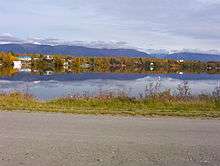
Located near Wasilla Lake and Lake Lucille, Wasilla is one of two cities in the Matanuska Valley. The community surrounds Mi. 39–46 of the George Parks Highway, roughly 43 highway miles (69.2 km) northeast of Anchorage. Nearly one third of the people of Wasilla drive the 40-minute commute to work in Anchorage every day.[22] Six miles to the southeast is Mount POW/MIA.
Climate
Wasilla has a climate similar to that of Anchorage, but with slightly warmer daytime maxima due to its inland location. On average, over the course of the entire year, there are 30–31 days of sub-0 °F (−18 °C) lows, 37–38 days of 70 °F (21 °C)+ highs, and 1.4 days of 80 °F (27 °C)+ highs. The average annual precipitation is 17 inches (430 mm), with 52 inches (132 cm) of snowfall.
| Climate data for Wasilla, Alaska | |||||||||||||
|---|---|---|---|---|---|---|---|---|---|---|---|---|---|
| Month | Jan | Feb | Mar | Apr | May | Jun | Jul | Aug | Sep | Oct | Nov | Dec | Year |
| Average high °F (°C) | 23.7 (−4.6) |
28.6 (−1.9) |
36.9 (2.7) |
49.1 (9.5) |
61.1 (16.2) |
67.7 (19.8) |
69.6 (20.9) |
67.4 (19.7) |
58.6 (14.8) |
42.9 (6.1) |
28.2 (−2.1) |
25.7 (−3.5) |
46.7 (8.2) |
| Average low °F (°C) | 8.2 (−13.2) |
11.8 (−11.2) |
18.8 (−7.3) |
28.2 (−2.1) |
36.7 (2.6) |
44.5 (6.9) |
49.2 (9.6) |
46.8 (8.2) |
39.7 (4.3) |
26.9 (−2.8) |
13.2 (−10.4) |
10.1 (−12.2) |
27.9 (−2.3) |
| Average precipitation inches (mm) | 0.8 (20) |
0.9 (23) |
0.5 (13) |
0.7 (18) |
0.8 (20) |
1.6 (41) |
2.5 (64) |
2.7 (69) |
2.7 (69) |
1.8 (46) |
1.2 (30) |
1.0 (25) |
17.2 (437) |
| Average snowfall inches (cm) | 8.4 (21.3) |
8.9 (22.6) |
5.8 (14.7) |
2.5 (6.4) |
0.1 (0.3) |
0 (0) |
0 (0) |
0 (0) |
0 (0) |
4.7 (11.9) |
8.7 (22.1) |
12.8 (32.5) |
52.1 (132.3) |
| Source: NOAA (1981–2010 normals),[23] Weatherbase (precip, snow)[24] | |||||||||||||
Demographics
| Historical population | |||
|---|---|---|---|
| Census | Pop. | %± | |
| 1930 | 51 | — | |
| 1940 | 96 | 88.2% | |
| 1950 | 97 | 1.0% | |
| 1960 | 112 | 15.5% | |
| 1970 | 300 | 167.9% | |
| 1980 | 1,559 | 419.7% | |
| 1990 | 4,028 | 158.4% | |
| 2000 | 5,469 | 35.8% | |
| 2010 | 7,831 | 43.2% | |
| Est. 2015 | 9,284 | [25] | 18.6% |
As of the census of 2000,[27] there were 5,469 people (up from 4,028[28] in 1990), 1,979 households, and 1,361 families residing in the city. The population density was 466.8 people per square mile (180.2/km²). There were 2,119 housing units at an average density of 180.9 per square mile (69.8/km²). The racial makeup of the city was 85.5% White, 0.6% Black or African American, 5.3% Native American, 1.3% Asian, 0.1% Pacific Islander, 1.3% from other races, and 5.9% from two or more races. Hispanic or Latino of any race were 3.7% of the population.
There were 1,979 households out of which 43.5% had children under the age of 18 living with them, 50.2% were married couples living together, 13.8% had a female householder with no husband present, and 31.2% were non-families. 23.5% of all households were made up of individuals and 6.8% had someone living alone who was 65 years of age or older. The average household size was 2.76 and the average family size was 3.27.
In the city the age distribution of the population shows 33.6% under the age of 18, 10.0% from 18 to 24, 30.7% from 25 to 44, 19.0% from 45 to 64, and 6.7% who were 65 years of age or older. The median age was 30. For every 100 females there were 99.5 males; for every 100 females age 18 and over, there were 95.0 males.
The median income for a household in the city was $48,226, and the median income for a family was $53,792. Males had a median income of $41,332 versus $29,119 for females. The per capita income for the city was $21,127. About 5.7% of families and 9.6% of the population were below the poverty line, including 12.6% of those under the age of 18 and 9.7% of those 65 and older.
Income and poverty
According to the United States Census Bureau, the median household income in Wasilla from 2010 to 2014 was $62,622, with a per capita income of $28,704 and a poverty rate of 11.2% in the same year.
Economy
Wasilla began as a transportation logistics and trade center serving natural resource extraction (mining, trapping & timber) followed by small-scale agricultural activity circa 1935; around 1975, construction of the Parks Highway substantially reduced travel time to Anchorage (approximately 43 miles away), encouraging the transition to a satellite bedroom community where workers commute to Anchorage for employment.[29] Local service employment has increased in recent years.[30]
About 35 percent of the Wasilla workforce commutes to Anchorage.[22] The local economy is diverse, and residents are employed in a variety of city, borough, state, federal, retail and professional service positions.[31] Tourism, agriculture, wood products, steel, and concrete products are part of the economy. One hundred and twenty area residents hold commercial fishing permits; commercial fishermen work seasonally in Lower Cook Inlet and distant Bristol Bay or the Gulf of Alaska & Prince William Sound (there are no commercial fisheries in Upper Cook Inlet).[30]
Recreation
The Museum of Alaska Transportation and Industry in Wasilla was established in 1967, "to give a home to the transportation and industrial remnants and to tell the stories of the people and the machines that opened Alaska to exploration and growth."[32]
In 2010, the Menard Center lost a tenant when the Arctic Predators did not play as a member of the Indoor Football League.[33]
Government
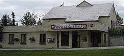
The Wasilla City Council is the city's legislature. It enacts laws and policy statements, sets the property tax rate, and approves the budget and funds for city services. It has six members, elected at-large by Wasilla residents for three year terms.[34] The mayor is elected separately. A run-off election is held if no candidate for mayor receives more than 40% of the votes cast. Run-off elections are not held for city council seats. All positions are part-time.
Mayors of Wasilla, Alaska
| Time in office | Name | Notes |
|---|---|---|
| 1974–1976 | Leo Nunley | |
| 1976–1980 | Elizabeth "Pat" Hjellen | |
| 1980–1983 | Harold Newcomb | |
| 1983–1984 | Marilyn McGuire | |
| 1984–1985 | Richard "Ken" DeCamp | [35] |
| 1985–1986 | Charlie Bumpus | [36] Died in office. Was succeeded by Dorothy G. Page as acting mayor. |
| 1986–1987 | Harold Newcomb | [37] |
| 1987–1996 | John C. Stein | [38] |
| 1996–2002 | Sarah Palin | [39] |
| 2002–2008 | Dianne M. Keller | [39] |
| 2008–2014 | Verne E. Rupright | [40] |
| 2014–present | Bert L. Cottle | [41][42] |
Education and health
Wasilla is served by the Matanuska-Susitna Borough School District. It has five high schools:[43]
- Burchell High School
- Mat-Su Career and Technical High School
- MidValley High School
- Wasilla High School
- Colony High School
There are also career training and technical colleges in Wasilla.
In January 2006 a new hospital, Mat-Su Regional Medical Center, opened. It is outside the city limits halfway between Wasilla and its twin town of Palmer.[44]
Transportation
The George Parks Highway in conjunction with the Glenn Highway connects Wasilla to Anchorage and communities on the Kenai Peninsula. The Parks also links the Matanuska Valley to northward to the rest of the state and Canada. The Alaska Railroad serves Wasilla.
The city-owned Wasilla Airport, with a paved 3,700 foot (1,130 m) runway, provides air taxi services.[45] The airport was formerly located in the city center before moving to a site on the western edge of the city during the 1980s. An anti-moose mat was installed around the runway in 2005, giving a light shock to animals which might otherwise wander into the path of moving aircraft. The old airport site is currently home to a city park. Wasilla also has eight public-use seaplane bases located on area lakes.[46] Private-use air facilities registered with the FAA include 43 land-based airstrips, eight additional seaplane bases, two heliports and one STOLport.[46]
Notable people
- Several members of rock bands Anatomy of a Ghost and Portugal. The Man, including lead singer of both bands John Gourley
- Chad Carpenter, cartoonist and creator of the comic strip Tundra[47]
- Lyda Green, the third and most recent female president of the Alaska Senate
- Levi Johnston, media personality and former fiancé of Bristol Palin (see below)
- Lisa Kelly of the History Channel program Ice Road Truckers
- Vic Kohring, state legislator implicated in the Alaska political corruption probe[48]
- Tom Mechler, chairman since 2015 of the Republican Party of Texas[49]
- Jeremy Morlock, a U.S. Army soldier who murdered three civilians in Afghanistan.[50][51]
- Members of the Palin family:
- Sarah Palin, former mayor of Wasilla, former Alaska Governor, and 2008 Republican vice presidential candidate
- Todd Palin, professional snowmobile racer, four-time Iron Dog race champion, husband of Sarah Palin
- Bristol Palin, Teen Abstinence Ambassador for the Candie's Foundation, daughter of Todd and Sarah Palin[52][53]
References
- ↑ 1996 Alaska Municipal Officials Directory. Juneau: Alaska Municipal League/Alaska Department of Community and Regional Affairs. January 1996. p. 159.
- ↑ 2015 Alaska Municipal Officials Directory. Juneau: Alaska Municipal League. 2015. p. 163.
- ↑ Alaska Economic Trends. Alaska Department of Labor and Workforce Development. Retrieved October 24, 2008.
- ↑ "Wasilla History". city of Wasilla. September 23, 2008.
- ↑ Bright, William (2004). Native American placenames of the United States. University of Oklahoma Press. p. 551. ISBN 978-0-8061-3598-4. Retrieved April 11, 2011.
- ↑ "The Last Glacial Maximum". Peter U. Clark, Arthur S. Dyke, Jeremy D. Shakun, Anders E. Carlson, Jorie Clark, Barbara Wohlfarth, Jerry X. Mitrovica, Steven W. Hostetler, A. Marshall McCabe. American Association for the Advancement of Science. August 7, 2009: Vol. 325. no. 5941, pp. 710 – 714. doi:10.1126/science.1172873. Retrieved January 27, 2010.
- 1 2 Hollander, Zaz (June 29, 2005). "Archaeological dig perplexes; Trapper Creek: Team from Nevada didn't discover what it had been expecting". Anchorage Daily News. Retrieved October 23, 2008.
- ↑ "Palmer History". Palmer Museum of History and Art. Archived from the original on January 13, 2009. Retrieved October 23, 2008.
- ↑ "About Knik". Wasilla Knik Historical Society. March 2006. Retrieved October 23, 2008.
- ↑ "About Wasilla, Alaska". Greater Wasilla Chamber of Commerce. 2007. Archived from the original on September 17, 2008. Retrieved October 23, 2008.
- ↑ "Wasilla: Community Overview". Community Database Online. Alaska Division of Community Advocacy. Retrieved October 23, 2008.
- ↑ Orth, Donald Orth (1967). Dictionary of Alaska Place Names, U.S. Geological Survey Professional Paper 567. U.S. Government Printing Office.
- ↑ Bauer, Scott. "Palin's speech has '30s roots, don't cha know: UW linguists’ research article." [[Milwaukee Journal Sentinel November 15, 2009]
- ↑ "Visitors: What's the Climate Like?". city of Wasilla, Alaska. August 19, 2008. Retrieved September 1, 2008.
Agriculture and natural resources sustained growth and the city was incorporated in 1974.
- ↑ §29.04.010 and §29.04.030 of the Alaska Code. Retrieved October 23, 2008.
- ↑ Hernandez, Raymond; Hershey Jr, Robert D.; Holloway, Lynette; Kennedy, Randy; Labaton, Stephen; Lewin, Tamar; Lewis, Neil A.; Onishi, Norimitsu; Schmitt, Eric; Bradsher, Keith (November 10, 1994). "The 1994 Elections: State by State; West". The New York Times. Retrieved September 9, 2008.
- ↑ "Alaska's 1994 General Election Results Summary". Alaska Division of Elections, State of Alaska. Archived from the original on August 1, 2008. Retrieved September 9, 2008.
- ↑ Alaska Economic Trends (PDF). Alaska Department of Labor and Workforce Development. January 2003.
- 1 2 D'Oro, Rachel (January 10, 2008). "Warming Forces Iditarod Changes". Fox News. Associated Press. Retrieved September 17, 2008.
- ↑ "US Gazetteer files: 2010, 2000, and 1990". United States Census Bureau. 2011-02-12. Retrieved 2011-04-23.
- ↑ "Dena'ina Qenaga – Placenames". Qenaga.org. Retrieved January 7, 2011.
- 1 2 "Community Profile: At Work". city of Wasilla, Alaska. July 9, 2008. Archived from the original on March 8, 2008. Retrieved September 1, 2008.
- ↑ "Station Name: AK WASILLA 3 S STATE AP". National Oceanic and Atmospheric Administration. Retrieved 2013-03-09.
- ↑ "Historical Weather for Wasilla, Alaska USA". weatherbase.com. Retrieved November 7, 2008.
- ↑ "Annual Estimates of the Resident Population for Incorporated Places: April 1, 2010 to July 1, 2015". Retrieved July 2, 2016.
- ↑ "Census of Population and Housing". Census.gov. Retrieved June 4, 2015.
- ↑ "Wasilla, Alaska". Census 2000 Demographic Profile Highlights. U.S. Census Bureau. Retrieved August 30, 2008.
- ↑ "Wasilla city, Alaska – Population Finder – American FactFinder". U.S. Census Bureau. Retrieved September 12, 2008.
- ↑ Interview Neil Fried, AK DOL economist @ 907 269-4861
- 1 2 "2011 Alaska Economic Trends". Labor.state.ak.us. January 3, 2011. Retrieved January 7, 2011.
- ↑ "January 2003 Trends" (PDF). Retrieved January 7, 2011.
- ↑ "About Us". Museum of Alaska Transportation and Industry. Retrieved September 1, 2008.
- ↑ Armstrong, Joshua (September 4, 2009). "IFL officially adds three teams". Fairbanks Daily News-Miner.
- ↑ "City Council". Department/Divisions. City of Wasilla. Retrieved February 8, 2010.
- ↑ "City of Wasilla Certification of Election Results". City of Wasilla. January 22, 1985. Retrieved January 7, 2011.
- ↑ "Charlie Bumpus Relishes His Maverick Reputation". Anchorage Daily News. December 17, 1985. Retrieved May 22, 2009.
- ↑ "Wasilla Official Dismissed New Mayor's Move Riles Councilmen". Anchorage Daily News. November 7, 1986. Retrieved May 22, 2009.
- ↑ "Mayor Palin – A Rough Record – Time". Time (magazine). September 2, 2008. Retrieved March 22, 2009.
- 1 2 "Mayor of Wasilla Dianne Keller – Who Succeeded Sarah Palin in Wasilla?". Esquire (magazine). Retrieved March 22, 2009.
- ↑ "City of Wasilla : Mayor Verne E. Rupright". City of Wasilla. Retrieved March 22, 2009.
- ↑ "CITY OF WASILLA — OFFICIAL RESULTS — REGULAR CITY ELECTION, OCTOBER 7, 2014". Office of the Wasilla City Clerk. October 14, 2014. Retrieved November 8, 2014.
- ↑ 2015 Alaska Municipal Officials Directory. Juneau: Alaska Municipal League. 2015. p. 163.
- ↑ "High School Listings". Matanuska-Susitna Borough School District. Archived from the original on August 4, 2008. Retrieved September 2, 2008.
- ↑ "Our History". Mat-Su Regional Medical Center. Archived from the original on March 26, 2008. Retrieved September 1, 2008.
- ↑ Airport page at city of Wasilla web site. Retrieved September 17, 2008.
- ↑ Wes Keller (August 27, 2008). "Tundra Creator Honored as Alaska's Cartoon Laureate" (Press release). Alaska State Legislature's House Majority. Retrieved September 1, 2008.
- ↑ Demer, Lisa; Kyle Hopkins (October 31, 2007). "Kohring neither defiant nor remorseful". Anchorage Daily News. Archived from the original on November 2, 2007. Retrieved November 3, 2007.
- ↑ "Thomas R. Mechler". intelius.com. Retrieved March 17, 2015.
- ↑ From Charley Keyes, CNN. "CNN". CNN. Retrieved January 7, 2011.
- ↑ Robin Hindery, Associated Press (March 24, 2011). "US soldier gets 24 years for murders of 3 Afghans". Associated Press. Retrieved March 26, 2011.
- ↑ "Candie's foundation". Candiesfoundation.org. November 16, 2010. Retrieved January 7, 2011.
- ↑ Collins, Gail (May 6, 2009). "Bristol Palin's New Gig". The New York Times. New York. Retrieved May 14, 2009.
External links
| Wikimedia Commons has media related to Wasilla, Alaska. |
| Wikivoyage has a travel guide for Wasilla. |
Municipalities and communities of Matanuska-Susitna Borough, Alaska, United States | ||
|---|---|---|
| Cities | 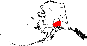 | |
| CDPs | ||
| Unincorporated communities | ||