Gorleston
| Gorleston-on-Sea | |
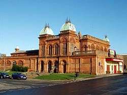 The Pavilion Theatre |
|
 Gorleston-on-Sea |
|
| Population | 5,548 (2011 Census.Ward)[1] |
|---|---|
| OS grid reference | TG520040 |
| District | Great Yarmouth |
| Shire county | Norfolk |
| Region | East |
| Country | England |
| Sovereign state | United Kingdom |
| Post town | GREAT YARMOUTH |
| Postcode district | NR31 |
| Dialling code | 01493 |
| Police | Norfolk |
| Fire | Norfolk |
| Ambulance | East of England |
| EU Parliament | East of England |
| UK Parliament | Great Yarmouth |
Coordinates: 52°34′33″N 1°43′25″E / 52.5757°N 1.7235°E
Gorleston-on-Sea, also known colloquially as Gorleston, is a settlement in Norfolk, England, on the south of Great Yarmouth. Situated at the mouth of the River Yare it was a port town at the time of the Domesday Book. The port then became a centre of fishing for herring along with salt pans used for the production of salt to preserve the fish. In Edwardian times the fishing industry rapidly declined and the town's role changed to that of a seaside resort.
History
Historically the town was in the county of Suffolk. In the Middle Ages it had two manors, and a small manor called Bacons. In 1832, it became a part of Great Yarmouth for electoral purposes. Finally in 1835 it merged with the town and became part of Great Yarmouth in the county of Norfolk. Gorleston Barracks were established in 1853.[2] There used to be two railway stations. Both were on the coastal line which joined Great Yarmouth with Lowestoft - Gorleston-on-Sea closed in 1970 whilst its neighbour, Gorleston North closed in 1942.
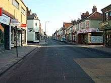
It is a seaside resort and tourist destination. Its main attraction is its sandy "Edwardian Beach." It has traditional seaside gardens and model boat pond. It also has a theatre opposite the pier called the Pavilion. The main shopping centre is on High Street. It has its own golf club. There is also the hospital and a library. The nearest railway station remaining open is the Great Yarmouth railway station. There is a lighthouse, lifeboat station and coastwatch station on Riverside Road.[3]
In the Great Storm of 1987, Gorleston experienced the highest wind speed recorded in the UK on that day, which was 122 mph (196 km/h).
The town is meticulously described in the novel 'Gorleston' by Henry Sutton (Sceptre, 1995) and in Philip Leslie's novels 'The History of Us' (Legend Press, 2009) and 'What Remains' (December House, 2013). Both Sutton and Leslie employ the actual names of roads and retail outlets in their work.
East Anglian School for Deaf and Blind Children
The East Anglian School for Deaf and Blind Children (for deaf children and for blind children) was established in Gorleston in 1912 and based there until it closed in 1985.[4] During the Second World War the school was evacuated to Aberpergwm House in Glynneath, Wales.[5] The headmaster's house in Gorleston was severely damaged by bombing in 1941. [6]
Notable residents
- William Fleming (GC) — highly decorated lifeboatman.
- Myleene Klass — television presenter, musician and former member of pop group Hear'say.
- Hannah Spearritt — actress and former member of pop group S Club 7.
- Jessica-Jane Applegate — Paralympian swimming gold-medallist.
See also
- Cliff Park Ormiston Academy, a secondary school in Gorleston
- Gorleston F.C., a Non-League football club who play at Emerald Park in Gorleston
References
- ↑ "Great Yarmouth Ward population 2011". Retrieved 24 August 2015.
- ↑ "Southtown Road Workshop Range". English Heritage. Retrieved 17 October 2016.
- ↑ RNLI history of Great Yarmouth & Gorleston lifeboat station.
- ↑ "East Anglian School for the Deaf and Blind" (GIF image). Norfolk Deaf History. Retrieved 9 April 2015.
- ↑ Gosse, Peter. "EAS moved to Wales During the War 1940-1945" (PDF). Norfolk Deaf History. Retrieved 9 April 2015.
- ↑ Clapham, Lucy (10 December 2012). "Blue plaque marks the spot of important Gorleston landmark". East Anglian Daily Press. Retrieved 15 November 2014.
Sources
- Norfolk Record Office Information Leaflet 33: Great Yarmouth, (Norwich: Norfolk Record Office, 2006)
External links
| Wikimedia Commons has media related to Gorleston. |
| Boroughs or districts | |
|---|---|
| Major settlements |
|
| Topics | |