Goryōkaku Station
Goryōkaku Station 五稜郭駅 | |
|---|---|
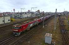
 Goryōkaku Station, May 2012 | |
| Location |
Hakodate, Hokkaido Japan |
| Operated by |
JR Hokkaido South Hokkaido Railway Company |
| Line(s) |
Hakodate Main Line South Hokkaido Railway Line |
| Connections |
|
| History | |
| Opened | 1911 |
Goryōkaku Station (五稜郭駅 Goryōkaku-eki) is a railway station on the Hakodate Main Line and South Hokkaido Railway Line in Hakodate, Hokkaido, Japan, operated by Hokkaido Railway Company (JR Hokkaido) and South Hokkaido Railway Company. The station is named after Goryōkaku fort, located about two kilometers from the station.
Lines
Goryōkaku Station is served by the Hakodate Main Line and the South Hokkaido Railway Line.
Station layout
The station has two island platforms serving four tracks.
Platforms
| 3-4 | ■ Hakodate Main Line | for Hakodate |
| 5-6 | ■ Hakodate Main Line | for Oshamambe and Sapporo |
| ■ South Hokkaido Railway Line | for Kikonai |
Adjacent stations
| « | Service | » | ||
|---|---|---|---|---|
| Hakodate Main Line | ||||
| Hakodate | Super Hokuto Hokuto Hakodate Liner |
Shin-Hakodate-Hokuto | ||
| Hakodate | Local | Kikyō | ||
| South Hokkaido Railway Line | ||||
| Terminus | Local | Nanaehama | ||
History

The station opened as a new station on the Hakodate Main Line on September 1, 1911.[1] It became the terminus of the Esashi Line on September 15, 1913.[1] With the privatization of JNR on April 1, 1987, the station came under the control of JR Hokkaido.[1] The freight terminal was renamed Hakodate Freight Terminal on March 12, 2011.[2]
Surrounding area
Hakodate Freight Terminal (函館貨物駅 Hakodate Kamotsu-eki) operated by Japan Freight Railway Company (JR Freight) is located next to the passenger station and was previously called Goryōkaku until it was renamed on March 12, 2011.[2]
- Goryōkaku fort
- Goryōkaku-Ekimae Post office
Bus services
- Hakodate Bus
References
| Wikimedia Commons has media related to Goryōkaku Station. |
Coordinates: 41°48′15″N 140°44′01″E / 41.8042°N 140.7337°E