Goulburn-Oberon Road
| Goulburn-Oberon Road New South Wales | |
|---|---|
| General information | |
| Type | Rural road |
| Length | 150 km (93 mi) |
| Major junctions | |
| North end | O'Connell Road, Oberon, New South Wales |
| Wombeyan Caves Road | |
| South end |
|
| Location(s) | |
| Major settlements | Norway, Black Springs, Swashfield, Porters Retreat, Curraweela, Richlands, Taralga, Myrtleville, Chatsbury, Tarlo, Kenmore |
| |
The Goulburn to Oberon Road is a New South Wales country road linking Goulburn near the Hume Highway to Oberon. The road is designated as Main Road 256 and is "seen as a future bypass of Sydney".[1]
At its northern end, the road passes through imposing plantations of radiata pine trees that supply the timber complex of Oberon.
It is now fully sealed, having undergone extensive work between 2002 and 2008. The final section of around 5 km long, located between the Abercrombie River and the end of Wombeyan Caves Road was sealed in February 2008. In 2007 the Upper Lachlan Shire received a grant of $710,000 over 3 years from the New South Wales Government to cover one third of the cost of realigning and sealing that remaining section and will allocate $1,420,000 of council funds over those three years to complete the work.[1] With the support of Oberon Council the work was completed in the first year.[2]
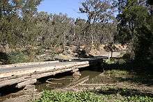
In conjunction with O'Connell Road from Oberon to Bathurst, this scenic route provides a leisurely and surprisingly direct route between Bathurst and Goulburn. The descent into the Abercrombie River Gorge from the North is particularly scenic.
The Wombeyan Caves Road, leading through the Wombeyan Caves reserve and on to Mittagong starts at the locality of Richlands, around half way between Goulburn and Oberon. The Laggan-Taralga Road from Crookwell ends in the historic town of Taralga a little further south. The Bannaby road to the locality of Bannaby also starts in Taralga.
List of towns, villages and localities on the Goulburn to Oberon Road
See also
References
- 1 2 http://upperlachlan.local-e.nsw.gov.au/files/5194/File/2007-2008ManagementPlan.pdf Upper Lachlan Shire Council 2007-2008 Management plan
- ↑ Oberon Council