Grabovica, Gornji Milanovac
| Grabovica, Gornji Milanovac Грабовица | |||
|---|---|---|---|
| Village | |||
 | |||
| |||
|
Motto: Упорност и знање је цена успеха (Serbian) "Persistence and knowledge is the price of success " | |||
 Grabovica, Gornji Milanovac | |||
| Coordinates: RS 44°01′N 20°30′E / 44.017°N 20.500°E | |||
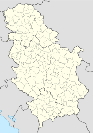
| Country |
| ||
| District | Moravica District | ||
| Statistical region | Šumadija and Western Serbia | ||
| Municipality | Gornji Milanovac | ||
| Government | |||
| • Type | Village council | ||
| • President of the Grabovica Settlement | Mileta Tešić [1] | ||
| Area | |||
| • Total | 598 sq mi (15,48 km2) | ||
| Elevation | 1,641 ft (500 m) | ||
| Population (2011)[2] | |||
| • Total | 456 | ||
| • Density | 7,630/sq mi (29,46/km2) | ||
| as for 2011 census | |||
| Time zone | CET (UTC+1) | ||
| • Summer (DST) | CEST (UTC+2) | ||
| Area code(s) | +381 32 | ||
| Website | http://www.gornjimilanovac.rs/lat/e-mesne.html | ||

Grabovica (Serbian Cyrillic:Грабовица, pronounced [graboʋit̪͡s̪a]) is a village in the municipality of Gornji Milanovac, Serbia. The name derivates from the word grab ("hornbeam"). According to the 2011 census, the village had a population of 456 people.[3]
Geography, Climate and Ecosystem
Grabovica is located 6 km from Gornji Milanovac. This village is dispersed settlement Rural type.
Main hamlets (or official they are called Cadastral community) in the village are:[4][5]
- Arnautići (meaning: Place of Inhabitants from Old Serbia territory),
- Čokanja (meaning: Hill),
- Parac (meaning: Nearness by town),
- Rapaj Brdo (meaning: Turnip tump ) and
- Votnjaci (meaning: Orchards).
Highest peaks in Grabovica are: Klik 721 m (2,365 ft), Veliki Vrh 691 m (2,267 ft), Mali Vrh 623 m (2,044 ft) and Parac 602 m (1975 ft).
Grabovica, like Gornji Milanovac has Humid continental climate.Hottest month of the year is July and August, while the coldest are January and February. Absolute maximum in air temperature range is 38.8 °C (101.8 °F) on July 6, 1950 and absolute minimum is −30.4 °C (−22.7 °F) on February 17, 1956. The average annual precipitation height are in the range of 788 mm (31.02 in). The most precipitation falls in period April–June and the least in October–February. Average snow cover keeps here in period of 160–190 days. Minimum mean wind speed is 1.7 - 2.6 m/s (3.11-5.05 knots) and maximum 13.8 - 20.7 m/s (26.83-40.24 knots). These maximum speed occurs here with southeastern, southwestern and southern winds. Annual average daily global sun radiation energy on a horizontal surface on territory of municipality Gornji Milanovac is between 3.8-4.0 kWh/m2 (0.33-0.35 BTU/ft2). Average recorded emission of CO2 is 0.52 tons. Relative humidity is 85% average in winter periods and 78.5 average in summer periods.
In this village there is various water resources. As proff of that, there is numerous water wells. Soil on its territory is in majority of brown earth on diabase. Vegetation period lasts 220–260 days. Forest vegetation makes 2/3 of total area and contains hornbeam, pilar, oak, acacia, etc. Plant vegetation consists of meadow grass (in majority), meadows and grassland. As for November 2015 and changes of the settlements territory boundaries of this village through this village circulate smaller Grabovica river and to a lesseer part on the north of the territory, rivers: Glogovac and Gruža.
History
There are several sites in Grabovica from the Roman and Byzantine eras. There are Roman archaeological sites in the hamlet of Arnauti-Kršić, some "Hungarian" sites (as local people calls them), and a church from the period of Austrian occupation of Serbia (1718-1739) in Parac. Radič Postupović (1413–1441), the senior aristocrat of the Serbian Despotate, founded the Monastery of the Great Annunciation (Veliko Blagoveštenje) in the village of Grabovica, sometime before 1429–30.[6] These monuments were demolished when the area underwent colonisation. In 1718 there were no households in Grabovica. According to Dr Milenko S. Filipović larger settlements begun from the period 1718-1739. In 1735 there was 15 households. The inhabitants were mainly settled from the Ottoman regions of Bosnia and Herzegovina, Montenegro and southwestern Serbia. The village saw an industrial progress in the 60's through the 90's breakup of Yugoslavia. In the period 1961, Grabovica had biggest population of 897 citizen.[7] In that period (1955-1999) major immigration came from Montenegro, Croatia, Kosovo and Metohija and some parts of Raška region. Decreasing trend of population number happened in period 1971-2002, shows census data [7] Also, Grabovica had a public owned Agricultural cooperative in period from 40's to the late 70's. They were specialized for redemption of wool, cereals, milk, eggs, crops, fruits and vegetables. Their head office were in place of today Cultural, Administration, Information and Assembly Center (CAIAC) of the settlement Grabovica. At the beginning of the 80's Grabovica Agriculture Cooperation merged with other Gornji Milanovac agriculture enterprises and function as member and partner of Gornji Milanovac big PIK "Takovo" (today "Swisslion Takovo" Concern) and other food industry across former Yugoslavia .
Demographics
There is 148 households in this village and number decreases, because bad economical situation. According to the date from 2011 census, in this village population by nationality is:
- Serbs- 455 and
- Unknown- 1 .
As regard as mother language, population is distributed in the next way:[8]
- Serbian language - 453,
- Croatian language- 1 and
- Unknown- 2.
In the village Grabovica, structure of the population by age and sex is what it follows:[9]
| Age | Total | Male | Female |
|---|---|---|---|
| 0-4 | 49 | 10 | 9 |
| 5-9 | 26 | 15 | 11 |
| 10-14 | 21 | 9 | 12 |
| 15-19 | 22 | 12 | 10 |
| 20-24 | 21 | 7 | 14 |
| 25-29 | 22 | 11 | 11 |
| 30-34 | 30 | 20 | 10 |
| 35-39 | 34 | 16 | 18 |
| 40-44 | 26 | 15 | 11 |
| 45-49 | 27 | 14 | 13 |
| 50-54 | 28 | 15 | 13 |
| 55-59 | 48 | 22 | 26 |
| 60-64 | 44 | 26 | 18 |
| 65-69 | 20 | 13 | 7 |
| 70-74 | 21 | 7 | 14 |
| 75-79 | 19 | 7 | 12 |
| 80-84 | 22 | 9 | 13 |
| 85 and more | 6 | 3 | 3 |
| Adult population | 337 | 190 | 187 |
| Average age | 44.3 | 43.5 | 45.2 |
Sports
During winter times on Ždreban peak recreational skiers and other athlets use some paths for their exercises. Grabovica have 2 ball open parks for recreation purpose:3x3 Basketball, Basketball, Tennis, Track racing, Snooker, Futsal, Handball and Table tennis. Grabovica, today have newly fotmed football (soccer) club FK Sparta Grabovica which was established in June 2015. This football (soccer) club does not have own football (soccer) stadium, but settlement council promised to realize that initiave in the periods which are ahead us.
Tourism and culture
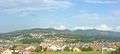
Grabovica has great potential for progress in area of tourism, thanks of theirs geographical position and panorama view over Gornji Milanovac and surroundings. Grabovica woods are popular for hunting on venison. The Ždreban peak of Grabovica is also and famous picnic place for 1 May celebration or International Workers' Day, even today. This village has a few private owned country hotels.
Grabovica has a Youth Culture and information center, currently under reconstruction. Plan is build modern center of the village with diversity of information (such as new tourist signs; information service; web page incorporated in Gornji Milanovac tourist organization web site for touristic purposes; hydro-meteorological, daily radiation, the concentration of allergens in the air information's; information's about road conditions and advice). This culture center is main place for gathering like for: organization of voting and referendums, youth parties, culture exposure, humanitarian actions, trading, family register, social-tax evidence and public session of the village citizens. Also in the past on the land of territory of this village was and the House of Serbian-Norwegian friendship. After new internal borders in municipality of Gornji Milanovac, this cultural center become a part of Gornji Milanovac settlement. Also there is mass grave with the monument for the fallen soldiers of the Austro-Hungarian Army and Serbian Royal Army on the same place (from the World War I). On the peak of Ždreban (engl. Foal) there are ruins of a planned Children Rehabilitation hospital (1950) but investments were insufficient, and there is no planned construction.
Through the winter, spring and summer periods in the areas of Grabovica hamlets, quad bikes tours (ATV tour) are being organized. This automotive sport adventure is more popular among the local population and tourist who visit municipality of Gornji Milanovac.
Also Grabovica offers to the lovers of night sky, great view on the stars (November–February and July–August), clean air and a diversity of ecosystem. In some parts of this village configuration of the terrain offers (in Parac) a panorama view on Gornji Milanovac and surroundings settlements.
Feast of the Ascension is the village patron day. During that celebration people of this village gathers for the launch or barbecue with their other family members and friends. Some residents donate food to the poor population of Gornji Milanovac.
Flag and Coat of Arms
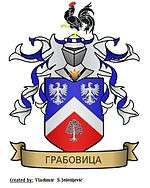
In socialistic era, Grabovica used simbols and flag of Territorial Defense of Yugoslavia like the most of villages in SFR Yugoslavia did. They used them in village sport and civil defense tournaments, as the seal in verification of various documents with indication of village Grabovica (only way to differentiate villages by the name)[10] and tactical squad of civilian units.[11] Now, Grabovica does not have their coat of arms, but there was only one heraldic newdate solution. In the last session (November 2015) of the village Council of Grabovica, Vladimir Jelesijević (author of the same Official Grabovica Coat of Arms) represented flag solution for this village. Flag is on the considerations process. Flag is canton shaped with horisontal order of the colors in accordance with the colors of Grabovica coat of arms. Meaning of the colors are: Blue-harmony, White-purity, Red-strength, Green-nature. In the upper left corner of the flag is represented green field with white hornbeam tree which is the main symbol of Grabovica village.
.JPG)
Notable people
Grabovica had/has several notable residents:[12][13][14]
- Milomir Marić, Serbian journalist, writer, and television presenter;
- Stanojka Joksić, Yugoslavian folk musician;
- Života M. Kapetanović, Lieutenant colonel of the Yugoslavian Royal Cavalry, architect of Hydro-Geothermal Resources, Planning and Constructioning and member of the teams of engineers who built Iron Gate I Hydroelectric Power Station;
- Srećko Radišić, was a notable fitness trainer for soccer (football) teams like FK Crvena Zvezda, Real Madrid C.F. and Kuwait national football team;
- Radivoje (alias Raša) Milovanović, first Yugoslavian athlete from this village on the Summer Olympic Games in Berlin;
- Ivan S. Šalavardić, notable rebellion in Second Serbian Uprising;
- Obrad Slović, rebellion in Second Serbian Uprising and obor-knez.
Economy
Many residents depends from Gornji Milanovac industry and economy. Many of them works in the following economic sectors:[15]
- Secondary sector- 106,
- Primary sector- 35,
- Tertiary sector- 48 and
- Unknown- 4.
Infrastructure
Through this village passes Road 177 and Regional bypass road Gornji Milanovac-Grabovica-Knić-Kragujevac. Also the major road that is passing through village, connecting other hamlets of Grabovica and center of manucipality Gornji Milanovac and in the same time it is detour, is road with mark L-12 (mark "L" stands for "Local road"). The nearest path to the center of municipality is 6.3 km (3.91 mi). Also turn to state highways E-763 (class Ia) is close by Grabovica. In sense of use civilian airports, nearest one is Morava Airport (local road L18-Lunjevica,Gornja Trepča, interpasses E-763 at Mrčajevci to Ladjevci). This village is connected to Water supply network Banjani (local supply) and Rzav (Moravica district regional supplier). Also, Grabovica is interconnect with Gornji Milanovac local supplier JP "Grejanje" of the natural gas network. As for internet infrastructure, residents of this village are connected by ADSL and it is in plan to set up one up steaming receiver for MMDS. On its terrain, Grabovica has one radio-television repeater and all residents are connected to the landline and mobile telephony. Major households in Grabovica are connected to municipality sewerage and waste systems, while in the other parts users are connected on own cesspits which are regular maintained independently or by waste and water management company JKP Gornji Milanovac.
Gallery
 View on Gornji Milanovac from nearby Grabovica village
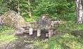 Drinking fountain in Grabovica village (peak Ždreban), near Gornji Milanovac
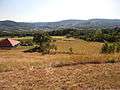
- View on Grabovica hill
 Rapaj brdo is the peak in village Grabovica (municipality of Gornji Milanovac, Republic of Serbia)
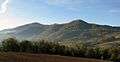
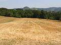 Hamlet of Parac is located in village Grabovica (Gornji Milanovac, Serbia) and view on Treska peak
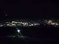 Night view on one part of Gornji Milanovac from Grabovica village (Hamlet of Parac)
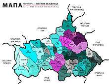 Map of the settlements in Gornji Milanovac and their territory organisation. Grabovica is marked under the number 19
Neighboring settlements with Grabovica
Grabovica is bordering with:[16]
 |
Nevade | Gornja Vrbava | | |
| Gornji Milanovac | |
Donja Vrbava | ||
| ||||
| | ||||
| Lunjevica | Jablanica |
External links
| Wikimedia Commons has media related to Gornji Milanovac. |
- Gornji Milanovac Settlement's council pages
- Tourist Organisation of the Municipality of Gornji Milanovac
- Weather forecast for Grabovica-Gornji Milanovac
References
- ↑ http://www.gornjimilanovac.rs/dokumenta/mz/predsednici-mz3.pdf| Presidents of the settlements in Gornji Milanovac; December 2014
- ↑ http://pod2.stat.gov.rs/ObjavljenePublikacije/Popis2011/Starost%20i%20pol-Age%20and%20sex.pdf|2011 Census of Serbia
- ↑ http://pod2.stat.gov.rs/ObjavljenePublikacije/Popis2011/Starost%20i%20pol-Age%20and%20sex.pdf|Census 2011 for Serbia
- ↑ Most of the names of Hamlets are Turkish origin, excluding Parac which is the word from Greek and Votnjaci which is from Serbian language.
- ↑ Živko Perišić "Poreklo imena sela mog", 2001
- ↑ Srpska akademija nauka. Istoriski institut (1973). Historical review. 20. p. 134.
- 1 2 Књига 9, Становништво, упоредни преглед броја становника 1948, 1953, 1961, 1971, 1981, 1991, 2002, подаци по насељима, Републички завод за статистику, Београд, маy 2004, ISBN 86-84433-14-9
- ↑ http://pod2.stat.gov.rs/ObjavljenePublikacije/Popis2011/Knjiga4_Veroispovest.pdf%7CRelligion | Religion structure and language in Republic of Serbia, 2011 census
- ↑ Population in Serbia by age and sex, Census 2011|http://pod2.stat.gov.rs/ObjavljenePublikacije/Popis2011/Starost%20i%20pol-Age%20and%20sex.pdf |Retrieved: November 2014
- ↑ Most villages used symbols and flag of Territorial Defense Units of Yugoslavia and the only way to differentiate villages was by the name which were added on the bottom of the flag or logo
- ↑ Territorial Defense of SFR Yugoslavia| http://lcweb2.loc.gov/cgi-bin/query/r?frd/cstdy:@field(DOCID+yu0183)| Retriwed: March 2015
- ↑ Ivan Dj. Milićević: "Kneževina Srbija", SKZ 1885
- ↑ Ana Stolić: "Državni popis stanovništva 1862/63", Zbornici Muzeja Rudničko-takovskog kraja i Medjuopštinski istorijski arhiv u Čačku, 2000 edition
- ↑ Milenko S. Filipović: "Naselja i poreklo stanovništva takovskog sreza" SANU, 1995
- ↑ Књига 1, Становништво, национална или етничка припадност, подаци по насељима, Републички завод за статистику, Београд, фебруар 2003, ISBN 86-84433-00-9
- ↑ Milenko S. Filipović, "Насеља и порекло становништва (књига 37)-СРПСКИ ЕТНОГРАФСКИ ЗБОРНИК" (књига LXXV)-Takovo Region (In Serbia), Belgrade, 1960
Coordinates: 44°01′N 20°30′E / 44.017°N 20.500°E