Graffignana
| Graffignana | ||
|---|---|---|
| Comune | ||
| Comune di Graffignana | ||
| ||
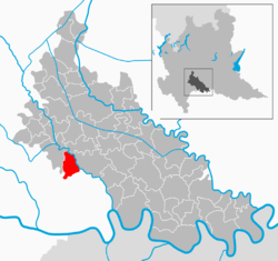 | ||
 Graffignana Location of Graffignana in Italy | ||
| Coordinates: 45°12′N 9°30′E / 45.200°N 9.500°ECoordinates: 45°12′N 9°30′E / 45.200°N 9.500°E | ||
| Country | Italy | |
| Region | Lombardy | |
| Province / Metropolitan city | Province of Lodi (LO) | |
| Area | ||
| • Total | 10.7 km2 (4.1 sq mi) | |
| Population (Dec. 2004) | ||
| • Total | 2,615 | |
| • Density | 240/km2 (630/sq mi) | |
| Time zone | CET (UTC+1) | |
| • Summer (DST) | CEST (UTC+2) | |
| Postal code | 26813 | |
| Dialing code | 0371 | |
| Website | Official website | |
Graffignana is a comune (municipality) in the Province of Lodi in the Italian region Lombardy, located about 40 km (25 mi) southeast of Milan and about 13 km (8.1 mi) south of Lodi. As of 31 December 2004, it had a population of 2,615 and an area of 10.7 km2 (4.1 sq mi).[1]
Graffignana borders the following municipalities: Sant'Angelo Lodigiano, Villanova del Sillaro, Borghetto Lodigiano, San Colombano al Lambro, Miradolo Terme.
Notable people
- Luigi Carlo Borromeo, (1893–1975), bishop of Pesaro
Demographic evolution

References
External links
This article is issued from Wikipedia - version of the 10/16/2016. The text is available under the Creative Commons Attribution/Share Alike but additional terms may apply for the media files.