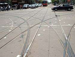
Grand union
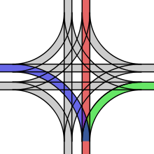
A grand union is a rail track junction where two double-track railway lines cross at grade, often in a street intersection or crossroads. A total of sixteen railroad switches (sets of points) allow streetcars (or in more rare installations, trains) coming from any direction to take any of the three other directions. The same effect may be achieved with two consequent wyes if the location allows for space.
Complexity
These types of complex junction are expensive to build and expensive to maintain. Special parts, sometimes made of manganese steel, are needed for each location where one rail crossed another (a "frog"); these parts often need to be custom-made and fitted for each single location, depending on the specific angle of crossing of the intersecting streets.
A full grand union junction consists of 88 frogs (where one rail crosses another rail), and 32 switchpoints (point blades) if single-point switches are not used. A tram or train crossing the junction will encounter four or twenty frogs within the space of crossing the junction.
For all of the possible tracks of a grand union to be used during normal operation, at least six different tram routes have to cross the union. In an intersection with lines oriented towards cardinal directions, these could be: north-south, north-east, north-west, south-east, south-west, and east-west.
Three-Quarter, Half, and Butterfly Unions
Three-quarter unions are similar to grand unions in that they are also rail track junctions where two double-track railway lines cross at grade, often in a street intersection or crossroads; the primary difference being that one corner of the crossing does not have curved junction tracks, with the union having a total of twelve railroad switches (sets of points).
Half unions are similar, but only have curved junction tracks on two adjoining corners of the intersection, with a total of eight switches/points.
Butterfly unions share the total of eight switches/points, but the curved junction tracks are on opposing corners.
Examples
Americas
Canada
- Edmonton: The Edmonton Radial Railway had a single grand union at the intersection of 109th Street and Jasper Avenue, although one side of the junction remained as a stub and was removed by the late 1930s.[1][2]
- Montreal: The system operated by Montreal Tramways Company (Montreal street railway system) had several grand unions, with one known to be at the intersection of Ste. Catherine and St. Lawrence Streets.[3]
- Toronto: The most extensive street railway system in the Americas is the Toronto streetcar system of the Toronto Transit Commission in southern Ontario, which has 19 four-way streetcar intersections, including the only extant grand unions remaining in the Western Hemisphere. The system includes three grand unions, five three-quarter unions, four half unions, and four butterfly unions. Some unions have additional connections that do not fit typical classifications, as well as a number of other nonstandard union types. The "traditional" grand unions are located at Bathurst and King (43°38'38.14"N 79°24'9.50"W); Spadina and King (43°38'43.73"N 79°23'42.09"W) and Spadina and Queen (43°38'55.43"N 79°23'46.91"W).[4] King and Dufferin (43°38'20.15"N 79°25'38.45"W) is a "7/8 union": it is missing the curve from southbound to westbound.
USA
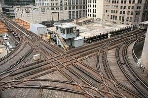
- Chicago: The Chicago Transit Authority has a three-quarter union at Tower 18, located on the northwest corner of The Loop (CTA). This union has the notable distinctions of not only being built entirely on elevated bridgework over the streets below, but also being fully equipped with third rails for power distribution.[5]
- Philadelphia: SEPTA has a surviving example of a half union located at the intersection of Chester Avenue and 49th Street;[6][7] and PTC previously had two butterfly unions, the first at Erie Ave and Old York Road[8] and the second at Lancaster Avenue and 33rd Street;[9] as well as a second half union at Allegheny and 22nd Street.[10]
- Pittsburgh: Pittsburgh's trolley system had a 3/4 union located at the intersection of 5th Avenue and Craig St.[11]
- Rochester, New York: Rochester's surface streetcar system had three full grand unions, all of which were located on Main Street, as well as two three-quarter unions, and three half unions.[12][13]
- Seattle: The Seattle-Tacoma Interurban was believed to have a single grand union, located at N. 34th St. and Fremont Ave.[14]
- San Francisco: The San Francisco Municipal Railway's light rail line has several half grand unions, often located at subway entrances. Examples include the facility at Church Street and Duboce Avenue and just outside the West Portal station. The agency's logo resembles a full grand union.
- Salt Lake City: The Utah Transit Authority's TRAX (light rail) system has 2 half grand unions(Main Street Interlocking at 40°45'38.2"N 111°53'28.3"W and the Airport Junction Interlocking at 40°46'09.7"N 111°54'08.4"W), 1 quarter grand union (Union Interlocking at 40°43'21.1"N 111°53'48.8"W), and a three interlocking combination that offers the effect of a half grand union (Lovendahl/Ephraim/Sugar Interlockings at 40°37'56.2"N 111°53'54.7"W).
Australasia
- Auckland, New Zealand: The Auckland system formerly had two grand unions, located at Queen Street's intersections with both Customs Street and Wellesley Street.[15]
- Melbourne, Australia: The only surviving grand union in the Southern Hemisphere is Balaclava Junction on the Melbourne tram system, in Australia. It is located at 37°52'21.56"S 145° 1'29.01"E.[16][17]
Europe
Austria
- Graz has a grand union at Jakominiplatz, 47° 4'1.45"N 15°26'30.92"E
Czech Republic
- Brno, has a 3/4 union located at 49°12'16.24"N 16°37'25.54"E.[18]
- Olomouc, has one 3/4 union located at 49°35'44.42"N 17°14'50.27"E.[19]
- Prague, has three grand unions, first at 50°6'12.65"N, 14°28'23.89"E[20] the second at 50°5'55.94"N, 14°25'59.76"E.[21] and the third at 50° 4'23.19"N 14°24'50.30"E, this Grand Union was rebuilt in 2003 and has curved trackwork as the streets are not aligned at the river crossing.
Germany
- Cottbus has one grand union at 51°45'39.86"N 14°19'51.39"E and a 3/4 grand union at 51°44'57.54"N 14°19'42.50"E.[22]
- Dresden has a grand union at 51° 3'49.47"N 13° 44'48.95"E (Albertplatz); a 5/8 grand union at 51° 3'47.55"N 13°44'13.53"E there is only a single connection on the north route, and a butterfly union at 51° 2'58.09"N 13°44'39.27"E (Dresden HBf)
- Duisburg has a butterfly union at 51°30'7.44"N 6°45'25.78"E
- Leipzig has a grand union at 51°20'39.35"N 12°22'15.99"E it is unique in interfacing with four tracks at Goerdelerring tram stop. There is a 3/4 grand union at 51°19'56.49"N 12°20'19.68"E, a half union at 51°20'31.31"N 12°21'31.15"E and butterfly unions at 51°19'12.95"N 12°19'48.80"E, 51°20'20.36"N 12°21'44.96"E and 51°21'44.93"N 12°21'55.79".
- Karlsruhe's system has a single grand union located at 49° 0'8.96"N 8°23'39.77"E.[23]
- Kassel's system has a single grand union located at 51°19'4.87"N 9°30'1.02"E.[24]
- Munich has one real grand union at Osfriedhof since the last track alteration in 2015 at 48°07'8.6"N 11°35'1"E. While not a traditional grand union, the Munich tram system has also a "Grand Circle" which has the same route function as a grand union and also provides a loop for all lines, it is located at Maxmonument in Maximilianstrasse, 48° 8'15.27"N, 11°35'17.02"E.[25]
Italy
- Milan: the Milan tram network currently has two grand unions. The first is a non standard design with divided North South tracks around a monument located at piazza 24 Maggio,[26] and the second located nearby at piazzale Porta Lodovica.[27] There used to be another large one until the 1990s located at piazza della Repubblica,[28] but it has since reduced to a wye junction still keeping the layout of diverging routes by the removal of the straight route to via Vittor Pisani.
Netherlands
- Amsterdam, Netherlands: As of 2009, the Amsterdam tram system continues to have four grand unions. However, none of them has tram routes running in all directions under normal operation. They are located at 52°21'17.39"N 4°54'4.49"E;[29] 52°21'45.91"N 4°52'31.04"E[30] and 52°22'12.13"N 4°51'0.94"E.[31] and 52°21'9.99"N 4°53'28.04"E;[32] (The tram tracks are truncated on the north side in the Ferdinand Bolstraat before joining due to engineering works; thus this grand union has only 12 switches and 6 dead ends.)[33]
- Rotterdam: the Rotterdam tram system has one three-quarter union, located at Vasteland - Westzeedijk 51°91'14.94"N, 4°47'74.85"E;[34]
Poland
- Kraków has three grand unions, one at 50° 3'27.42"N 19°57'32.40"E one at 50° 3'23.40"N 19°56'43.63"E and one at 50° 4'46.65"N 20° 1'38.49"E. There is a "Grand Circle" at Centralny Square, 50° 4'19.56"N 20° 2'14.46"E, the "Grand Circle" which has the same route function as a grand union and also provides a loop for all lines. There is a 3/4 union at 50° 3'6.26"N 19°56'30.22"E and a 5/8 union at 50° 4'24.31"N 20° 1'2.89"E.
- Poznań: The Poznań Tram system has 6 grand unions, which may be the most extant in any city. They are located at: 52°24'37.94"N, 16°54'48.53"E;[35] 52°24'28.02"N, 16°54'44.97"E;[36] 52°24'9.54"N, 16°53'20.65"E;[37] 52°23'24.39"N, 16°53'39.07"E;[38] 52°22'48.68"N, 16°56'35.21"E[39] and 52°23'57.53"N, 16°57'8.97"E.[40] All can be seen in detail on Google Earth.
- Warsaw: The Warsaw system has two grand unions, first at 52°14'30.79"N 20°59'37.00"E[41] and second at 52°14'13.30"N 20°58'48.62"E.[42] There is a 3/4 union at 52°15'17.24"N 20°58'57.11"E.[43]
Russia
- Kazan: Kazan Tram system had one grand union. It is located at 55.780459 N, 49.112853 E. Street View in Google Earth shows that this Grand Union has been partially removed, portions still remain in the pavement in 2013. [44]
- Moscow: Moscow Tram system has one 3/4 union on Preobrazhenskaya Ploshad [45]
- Saint-Petersburg: Saint-Petersburg Tram system has one 3/4 union on Svetlanovskaya Ploshad [46]
Slovakia
- Košice, has one grand union at 48° 42' 18"N 21° 14' 35"E
Switzerland
- Basle, The Basle system has a single (nonstandard) grand union located at 47°33'4.83"N 7°35'41.89"E.[47]
United Kingdom
- The UK had at least four grand unions, at Salford, South Shields, Liverpool, and Walthamstow. The components of the Salford union are presently stored at the National Tramway Museum at Crich.
See also
| Wikimedia Commons has media related to Grand unions. |
References
- ↑ Edmonton Radial Railway 1924 track map Archived July 6, 2011, at the Wayback Machine.
- ↑ "Edmonton Radial Railway Society photograph, 109th St. and Jasper Ave., 1904". Edmonton-radial-railway.ab.ca. Retrieved 2013-01-07.
- ↑ "Musée McCord Museum photograph - Tramway crossing under construction, 1893". Mccord-museum.qc.ca. Retrieved 2013-01-07.
- ↑ http://transit.toronto.on.ca/archives/maps/cars06.pdf
- ↑ www.Chicago-L.org Photo "tower18l.jpg" taken June 19, 2006.(Retrieved November 2009)
- ↑ "Original PRT specialwork drawing sheet 10, chart 48". Phillytrolley.org. 1919-06-30. Retrieved 2013-01-07.
- ↑ "PTC Track Map detail, 1954, bottom right corner of image". Phillytrolley.org. Retrieved 2013-01-07.
- ↑ "Original PRT specialwork drawing sheet 16, chart 66". Phillytrolley.org. 1919-06-30. Retrieved 2013-01-07.
- ↑ "PTC Track Map detail, 1954, center left of image". Phillytrolley.org. Retrieved 2013-01-07.
- ↑ "PTC Track Map detail, 1954, center left of image". Phillytrolley.org. Retrieved 2013-01-07.
- ↑ "Partial photo of location". BCoolidge Pittsburgh Trolleys. 2005-11-24. Retrieved 2016-10-25.
- ↑ "Map of Rochester Subway, see inset section for surface track layout". Rocwiki.org. 2005-03-20. Retrieved 2013-01-07.
- ↑ "Powers Building photograph, Rochester NY, 1904". Shorpy.com. Retrieved 2013-01-07.
- ↑ http://pauldorpat.com/wp-content/uploads/2010/09/Waiting-for-8-14-23-THENWEB.jpg
- ↑ Graham Stewart, The End of the Penny Section: When Trams Ruled the Streets of New Zealand, rev ed. (Wellington: Grantham House, 1993), p. 149.
- ↑ "Victorian Heritage Database: photographs and diagram of junction". Vhd.heritage.vic.gov.au. Retrieved 2013-01-07.
- ↑ Google Maps: 217 Balaclava Rd, Caulfield North VIC 3161, Australia
- ↑ Google Maps: Jugoslávská 18 613 00 Brno-sever, Czech Republic
- ↑ Google Maps: Palackého 621/1 779 00 Olomouc, Czech Republic
- ↑ Google Maps: Zenklova 180 00 Praha 8, Česká republika
- ↑ Google Maps: Strossmayerovo náměstí 976/1 170 00 Praha 7-Holešovice, Czech Republic
- ↑ Gleisplan der Straßenbahn Cottbus
- ↑ Google Maps: Karlstraße 63 76137 Karlsruhe, Germany
- ↑ Google Maps: Untere Königsstraße 60 34117 Kassel, Germany
- ↑ Google Maps: Maximilianstraße 47 80538 München, Germany
- ↑ Google Maps: Piazza 24 Maggio, Milano Italy
- ↑ Google Maps: Piazzale Porta Lododica, Milano Italy
- ↑ Google Maps: Piazza della Repubblica, Milano Italy
- ↑ Google Maps: Van Woustraat 83III 1074 Amsterdam, The Netherlands
- ↑ Google Maps: Eerste Constantijn Huygensstraat 98 1054 Amsterdam, The Netherlands
- ↑ Google Maps: Jan Evertsenstraat 144II 1056 Amsterdam, The Netherlands
- ↑ Google Maps: Ceintuurbaan 55-157 1072 Amsterdam, The Netherlands
- ↑ see Sporenplan.nl
- ↑ Google Maps: Vasteland - Westzeedijk Rotterdam, The Netherlands
- ↑ Google Maps: Franklina Roosevelta 11, Poznań, Poland
- ↑ Google Maps: Rondo Kaponiera, Poznań, Poland
- ↑ Google Maps: Rondo Jana Nowaka-Jeziorańskiego, Poznań, Poland
- ↑ Google Maps: Hetmańska 57, Poznań, Poland
- ↑ Google Maps: E261 Poznań, Poland
- ↑ Google Maps: E261 Poznań, Poland
- ↑ Google Maps: 629 Warszawa, Poland
- ↑ Google Maps: Rondo Kercelak, Warszawa, Poland
- ↑ Google Maps: Rondo Zgrupowania AK "Radosław", Warszawa, Poland
- ↑ Google Maps: 55.780459 N, 49.112853 E
- ↑ Google Maps: Preobrazhenskaya Ploshad, Moscow Russia
- ↑
- ↑ Google Maps: Aeschenplatz 1 4052 Basel, Switzerland