Granja, Ceará
| Granja | |||
|---|---|---|---|
| |||
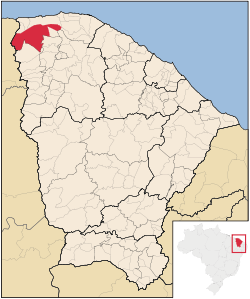 Location of Granja in Ceará | |||
| Coordinates: 03°07′12″S 40°49′33″W / 3.12000°S 40.82583°WCoordinates: 03°07′12″S 40°49′33″W / 3.12000°S 40.82583°W | |||
| Country | Brazil | ||
| Region | Northeast | ||
| State | Ceará | ||
| Founded | 1776 | ||
| Government | |||
| • Mayor | Francisco Geovane da Rocha Brito | ||
| Area | |||
| • Total | 2,697.202 km2 (1,041.396 sq mi) | ||
| Elevation | 10 m (30 ft) | ||
| Population (2008) | |||
| • Total | 53,486 | ||
| • Density | 19.9/km2 (52/sq mi) | ||
| [1] | |||
| Time zone | AST (UTC-3) | ||
| HDI (2000) | 0.554 – medium[2] | ||

Granja is the westernmost municipality in the Brazilian state of Ceará.
References
This article is issued from Wikipedia - version of the 5/11/2016. The text is available under the Creative Commons Attribution/Share Alike but additional terms may apply for the media files.