Grave Circle A, Mycenae
| Grave Circle A | |
|---|---|
|
Native name Greek: Ταφικός περίβολος A' | |
|
Grave Circle A (right) and the main entrance of the citadel (left). | |
| Location | Mycenae |
| Area | Argolis, Greece |
| Formed | 16th century BC |
| Built for | Resting place of the Mycenaean ruling families |
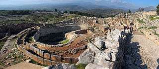
Grave Circle A in Mycenae is a 16th-century BC royal cemetery situated to the south of the Lion Gate, the main entrance of the Bronze Age citadel of Mycenae, southern Greece.[1] This burial complex was initially constructed outside the fortification walls of Mycenae, but was ultimately enclosed in the acropolis when the fortifications were extended during the 13th century BC.[1] Grave Circle A and Grave Circle B, the latter found outside the walls of Mycenae, represent one of the major characteristics of the early phase of the Mycenaean civilization.[2]
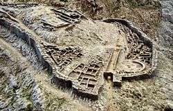
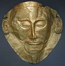
The circle has a diameter of 27.5 m (90 ft) and contains six shaft graves, where a total of nineteen bodies were buried. It has been suggested that a mound was constructed over each grave, and funeral stelae were erected. Among the objects found were a series of gold death masks, additionally beside the deceased were full sets of weapons, ornate staffs as well as gold and silver cups. The site was excavated by the archaeologist Heinrich Schliemann in 1876, following the descriptions of Homer and Pausanias. One of the gold masks he unearthed became known as the "The Death Mask of Agamemnon", ruler of Mycenae according to Greek mythology. However, it has been proved that the burials date circa three centuries earlier, before Agamemnon is supposed to have lived.
The valuable objects found in the graves suggest that powerful rulers were buried in this site. Although Agamemnon was supposed to have lived centuries later, these graves might have belonged to the former ruling dynasty of Mycenae – according to Greek mythology, the Perseides.[3]
Background
During the end of the 3rd millennium BC (circa 2200 BC), the indigenous inhabitants of mainland Greece underwent a cultural transformation attributed to climate change, local events and developments (i.e. destruction of the "House of Tiles"), as well as to continuous contacts with various areas such as western Asia Minor, the Cyclades, Albania, and Dalmatia.[4] These Bronze Age people were equipped with horses, surrounded themselves with luxury goods, and constructed elaborate shaft graves.[5] The acropolis of Mycenae, one of the main centers of Mycenaean culture, located in Argolis, northeast Peloponnese, was built on a defensive hill at an elevation of 128 m (420 ft) and covers an area of 30,000 m2 (320,000 sq ft).[1] The Shaft Graves found in Mycenae signified the elevation of a new Greek-speaking royal dynasty whose economic power depended on long-distance sea trade.[6] Grave Circles A and B, the latter found outside the walls of Mycenae, represent one of the major characteristics of the early phase of the Mycenaean civilization.[2]
History

Mycenaean shaft graves are essentially an Argive variant of the rudimentary Middle Helladic funerary tradition with features derived from Early Bronze Age traditions developed locally in mainland Greece.[7] Grave Circle A, formed circa 1600 BC as a new elite burial place, was probably first restricted to men and seems to be a continuation of the earlier Grave Circle B and correlates with the general social trend of higher burial investment taking place throughout entire Greece that time.[8] The Grave Circle A site was part of a larger funeral place from the Middle Helladic period. At the time it was built, during the Late Helladic I (1600 BC),[2] there was probably a small unfortified palace on Mycenae,[3] while the graves of the Mycenaean ruling family remained outside of the city walls.[9] There is no evidence of a circular wall around the site during the period of the burials.[10] The last interment took place circa 1500 BC.[11]
Immediately after the last interment, the local rulers abandoned the shaft graves in favour of a new and more imposing form of tomb already developing in Messenia, south Peloponessus, the tholos.[12] Around 1250 BC, when the fortifications of Mycenae were extended, the Grave Circle was included inside the new wall. A double ring peribolos wall was also built around the area.[13] It appears that the site became a temenos (sacred precinct), while a circular construction, possibly an altar was found above one grave.[14] The burial site had been replanned as a monument, an attempt by the 13th century BC Mycenean rulers to appropriate the possible heroic past of the older ruling dynasty.[15] Under this context, the land surface was built up to make a level precinct for ceremonies, with the stelae over the graves being re-erected. A new entrance, the Lion Gate, was constructed near the site.[11]
Findings

Grave Circle A, with a diameter of 27.5 m (90 ft), is situated on the acropolis of Mycenae southeast of the Lion Gate. The site is surrounded by two rows of slabs, while the space between the rows was filled with earth and roofed with slabs. The Grave Circle contains six shaft graves, the smallest of which is measured at 3.0 m by 3.5 m and the largest measured at 4.50 m by 6.40 m (the depth of each shaft grave ranges from 1.0 m to 4.0 m). Over each grave a mound was constructed and stelae were erected.[16] These stelae had been probably erected in memory of the Mycenaean rulers buried there; three of them depict chariot scenes.[2]
A total of nineteen bodies – eight men, nine women and two children[10] – were found in the shafts, which contained two to five bodies each (with the exception of Grave II, which was a single burial).[2] Among the findings, boars' tusks were found in Grave IV, as well as five golden masks in Graves IV and V. One of them, the supposed Mask of Agamemnon, was found in Grave V. Additionally, gold and silver cups, including Nestor's Cup and the Silver Siege Rhyton, were found by the side of the deceased. A number of gold rings, buttons and bracelets were also found.[2] Most of the graves were equipped with full sets of weapons, especially swords,[17] and the figural depictions of the objects show fighting and hunting scenes.
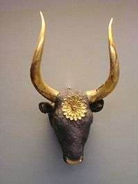
Many objects were designed to signify the social rank of the deceased, for instance, decorated daggers, which were objects d'art and cannot be considered real weapons. Ornate staffs as well as a scepter from Grave IV clearly indicate a very significant status of the deceased.[18] Items such as bulls' heads with a double axe display clear Minoan influences.[19] At the time that the Grave Circle was built, the Mycenaeans had not yet conquered Minoan Crete. Although it seems that they recognized the Minoans as the providers of the finest in design and craftsmanship, most of the objects decorated in Minoan style and buried in Grave Circle A are not of Minoan but of indigenous craftsmanship.[20] On the other hand, certain motifs such as fighting and hunting scenes are clearly of Mycenaean style.[21]
Excavations

The site of Mycenae was the first in Greece to be subjected to modern archaeological excavation.[22] It was excavated by the German archaeologist Heinrich Schliemann in 1876.[11] Schliemann, inspired by Homer’s descriptions in the Iliad, in which Mycenae is termed "abounding in gold", began digging there.[22] He was also following the accounts of the ancient geographer Pausanias who, during the 2nd century AD, described the once prosperous site and mentioned that according to a local tradition, the graves of Agamemnon and his followers, including his charioteer Eurymedon and the two children of Cassandra, were buried within the citadel.[23] What Schliemann discovered in his excavation satisfied both his opinion of Homer's historical accuracy and his craving for valuable treasures. Among the objects he unearthed in Grave Circle A was a series of gold death masks, including one he proclaimed "The Death Mask of Agamemnon".[22] Schliemann cleared five shafts and recognized them as the graves mentioned by Pausanias. He stopped his exploration after the fifth grave was explored, believing that he had finished excavating the Grave Circle, however a year later Panagiotis Stamatakis found a sixth shaft grave.[24]
It has since been demonstrated that the burials in Grave Circle A date from 16th century BC, before the traditional time of the Trojan War (13th-12th century BC), in which Agamemnon is supposed to have participated.[22]
| Wikimedia Commons has media related to Grave Circle A. |
References
Citations
- 1 2 3 "The Bronze Age on the Greek Mainland: Mycenaean Greece – Mycenae". Athens: Foundation of the Hellenic World. 1999–2000. Retrieved 9 March 2011.
- 1 2 3 4 5 6 Komita 1982, p. 60.
- 1 2 Castleden 2005, p. 42.
- ↑ Pullen 2008, p. 36; Forsén 1992, pp. 251–257.
- ↑ Hielte 2004, pp. 27–94.
- ↑ Dickinson 1977, pp. 53, 107; Anthony 2007, p. 48: "The Mycenaean civilization appeared rather suddenly with the construction of the spectacular royal Shaft Graves at Mycenae, dated about 1650 BCE, about the same time as the rise of the Hittite empire in Anatolia. The Shaft Graves, with their golden death masks, swords, spears, and images of men in chariots, signified the elevation of a new Greek-speaking dynasty of unprecedented wealth whose economic power depended on long-distance sea trade."
- ↑ Dickinson 1999, pp. 103, 106–107.
- ↑ Heitz 2008, p. 21.
- ↑ Burns 2010, p. 80.
- 1 2 Gates 2003, p. 133.
- 1 2 3 Geldard 2000, p. 157.
- ↑ Castleden 2005, p. 97.
- ↑ Morris & Powell 1997, John Bennet, "Homer and the Bronze Age", p. 516.
- ↑ Antonaccio 1995, p. 49.
- ↑ Fields & Spedaliere 2004, p. 25.
- ↑ Komita 1982, pp. 59–60.
- ↑ Graziadio 1991, pp. 403–440.
- ↑ Graziadio 1991, p. 406.
- ↑ Heitz 2008, p. 24.
- ↑ Heitz 2008, p. 25.
- ↑ Gates 2003, p. 134.
- 1 2 3 4 Sansone 2004, "Greece in the Bronze Age", pp. 7–8.
- ↑ Mylonas 1957, p. 122.
- ↑ Mylonas 1957, p. 8.
Sources
- Anthony, David W. (2007). The Horse, the Wheel, and Language: How Bronze-Age Riders from the Eurasian Steppes Shaped the Modern World. Princeton, New Jersey: Princeton University Press. ISBN 0-691-05887-3.
- Antonaccio, Carla Maria (1995). An Archaeology of Ancestors: Tomb Cult and Hero Cult in Early Greece. Lanham, Maryland: Rowman and Littlefield Publishers, Incorporated. ISBN 0-8476-7942-X.
- Burns, Bryan E. (2010). Mycenaean Greece, Mediterranean Commerce, and the Formation of Identity. New York, New York: Cambridge University Press. ISBN 0-521-11954-5.
- Castleden, Rodney (2005). Mycenaeans. London and New York: Routledge. ISBN 0-415-36336-5.
- Dickinson, Oliver (December 1999). Invasion, Migration and the Shaft Graves. Bulletin of the Institute of Classical Studies. 43. pp. 97–107. doi:10.1111/j.2041-5370.1999.tb00480.x.
- Dickinson, Oliver (1977). The Origins of Mycenaean Civilization. Götenberg: Paul Aströms Förlag.
- Fields, Nic; Spedaliere, Donato (2004). Mycenaean Citadels c. 1350-1200 BC. Oxford, United Kingdom: Osprey Publishing. ISBN 1-84176-762-X.
- Forsén, Jeannette (1992). The Twilight of the Early Helladics. Partille, Sweden: Paul Aströms Förlag. ISBN 91-7081-031-1.
- Gates, Charles (2003). Ancient Cities: The Archaeology of Urban Life in the Ancient Near East and Egypt, Greece, and Rome. New York, New York: Routledge. ISBN 0-415-12182-5.
- Geldard, Richard G. (2000). The Traveler's Key to Ancient Greece: A Guide to Sacred Places. Quest Books. ISBN 0-8356-0784-4.
- Graziadio, Giampaolo (July 1991). "The Process of Social Stratification at Mycenae in the Shaft Grave Period: A Comparative Examination of the Evidence" (PDF). American Journal of Archaeology. 95 (3): 403–440.
- Heitz, Christian (2008). "Burying the Palaces? Ideologies in the Shaft Grave Period." (PDF). University of Heidelberg. pp. 1–38. Retrieved 11 March 2011.
- Hielte, Maria (December 2004). "Sedentary versus Nomadic Life-Styles: The 'Middle Helladic People' in southern Balkan (late 3rd & first Half of the 2nd Millennium BC)". Acta Archaeologica. 75 (2): 27–94. doi:10.1111/j.0065-001X.2004.00012.x.
- Komita, Nobuo (1982). "The Grave Circles at Mycenae and the Early Indo-Europeans" (PDF). Research Reports of Ikutoku Technical University (A-7): 59–70.
- Morris, Ian; Powell, Barry B. (1997). A New Companion to Homer. Leiden, The Netherlands: Brill. ISBN 90-04-09989-1.
- Mylonas, George Emmanuel (1957). Ancient Mycenae: The Capital City of Agamemnon. Princeton, NJ: Princeton University Press.
- Pullen, Daniel (2008). "The Early Bronze Age in Greece". In Shelmerdine, Cynthia W. The Cambridge Companion to the Aegean Bronze Age. Cambridge and New York: Cambridge University Press. pp. 19–46. ISBN 978-0-521-81444-7.
- Sansone, David (2004). Ancient Greek Civilization. Malden (Massachusetts), Oxford (United Kingdom), Carlton (Victoria, Australia): Blackwell Publishing Ltd. ISBN 0-631-23236-2.
Further reading
- Chadwick, John (1976). The Mycenaean World. Cambridge, UK: Cambridge University Press. ISBN 0-521-29037-6.
- French, Elizabeth B. (2002). Mycenae: Agamemnon's Capital. Stroud: Tempus. ISBN 0-7524-1951-X.
- Mylonas, George E. (1983). Mycenae Rich in Gold. Athens: Ekdotike Athenon.
- Wace, Alan John Bayard (1964) [1949]. Mycenae: An Archaeological History and Guide. New York: Biblo and Tannen.
Coordinates: 37°43′49″N 22°45′22″E / 37.73028°N 22.75611°E