Great Bahama Canyon
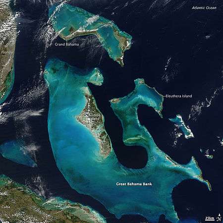
The Bahamas as seen from space. The egress of the Great Bahama Canyon into the Atlantic Ocean is the dark blue channel at upper center.
The Great Bahama Canyon is a V-shaped[1] submarine canyon system in the Bahamas that cuts between the Abaco Islands to the north and Eleuthera island to the south. It separates the Bahama Banks and forms one of the deepest underwater canyon systems known.[2] There are three branches: the Tongue of the Ocean running south between the Andros and New Providence, and the northeast and northwest Providence Channel.[3] The canyon walls reach heights of 5 kilometres (3 mi);[1] taller than any canyon walls on land. This canyon system has remained open through a process of submarine erosion.[1]
References
- 1 2 3 Andrews, James E.; Shepard, Francis P.; Hurley, Robert J., "Great Bahama Canyon", Bulletin of the Geological Society of America, 81 (4): 1061–1078, doi:10.1130/0016-7606(1970)81[1061:GBC]2.0.CO;2
- ↑ Riley, Sandra; Peters, Thelma (2000), Homeward Bound: A History of the Bahama Islands to 1850 With a Definitive Study of Abaco in the American Loyalist Plantation Period, Riley Hall, p. 2, ISBN 0966531027.
- ↑ Claridge, Diane Elaine; Durban, John William; Morin, Phillip, Distribution, Abundance and Population Structuring of Beaked Whales in the Great Bahama Canyon, Northern Bahamas (PDF), Office of Naval Research, retrieved 2012-07-07
This article is issued from Wikipedia - version of the 11/2/2016. The text is available under the Creative Commons Attribution/Share Alike but additional terms may apply for the media files.