Great Egg Harbor River
| Great Egg Harbor Scenic and Recreational River | |
|---|---|
|
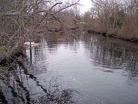
The Great Egg Harbor River in Mays Landing in 2006 | |
| Location | Atlantic, Gloucester & Camden counties, New Jersey, U.S. |
| Coordinates | 39°18′15″N 74°38′59″W / 39.30417°N 74.64972°WCoordinates: 39°18′15″N 74°38′59″W / 39.30417°N 74.64972°W |
| Area | 710 acres (2.9 km2) |
| Established | October 27, 1992 |
The Great Egg Harbor River is a 55.0-mile-long (88.5 km) river in southern New Jersey in the United States.[1] It is one of the major rivers that traverse the largely pristine Pinelands, draining 308 square miles (800 km2) of wetlands into the Atlantic Ocean at Great Egg Harbor, from which it takes its name.
Great Egg Harbor (and thus the river) got its name from Dutch explorer Cornelius Jacobsen Mey. In 1614, Mey came upon the inlet to the Great Egg Harbor River. The meadows were so covered with shorebird and waterfowl eggs that he called it "Eyren Haven" (Egg Harbor). Today, the National Park Service considers it one of the top 10 places in North America for birding.[2]
Description
The Great Egg Harbor River rises in the suburbs southeast of Camden near Berlin and flows generally southeast, to the south of the Atlantic City Expressway, entering Great Egg Harbor approximately 5 miles (8 km) southwest of Atlantic City. The lower 10 miles (16 km) of the river provide a navigable estuary as far as Mays Landing. The Tuckahoe River enters Great Egg Harbor just to the south of the mouth of the river.
Before the arrival of Europeans to the area in the 18th century, it was inhabited by Lenape. During the American Revolutionary War, its estuary sheltered privateers. The presence of "bog iron" along the river provided material for cannonballs and led to the construction of blast furnaces, as well as glass and brick factories, until the middle of the 19th century.
In 1992, the United States Congress designated 129 miles (208 km) of the river and its tributaries as the Great Egg Harbor Scenic and Recreational River, as part of the National Wild and Scenic River system.[3] It is the longest canoeing river within the Pinelands. It can be paddled for 47 miles (76 km) from New Brooklyn, near Route 536, all the way to Beesley's Point.[4] The river is noted for its tea-colored "cedar water", the product of the iron and tannin content of the fallen cedar leaves along much of its length.[2] It provides abundant habitat for waterfowl in the region. The fish populations include striped bass and alewife herring.
As of July 2015, 5,635.77 acres (22.8072 km2) of land along the river in Atlantic County is owned and administered by the New Jersey Division of Fish and Wildlife as the Great Egg Harbor River Wildlife Management Area.[5]
See also
Tributaries
References
- ↑ U.S. Geological Survey. National Hydrography Dataset high-resolution flowline data. The National Map, accessed April 1, 2011
- 1 2 "Great Egg Harbor National Wild & Scenic & River". Nat'l Park Service. Retrieved 20 January 2012.
- ↑ "Great Egg Harbor Scenic and Recreational River", National Park Service. Accessed July 7, 2008.
- ↑ Edward Gertler, Garden State Canoeing: A Paddler's Guide to New Jersey, Seneca Press, p. 127, ISBN 0-9605908-5-4
- ↑ New Jersey Division of Fish and Wildlife, Wildlife Management Areas. Retrieved October 19, 2015.