Greer County, Texas
| Greer County, Texas | |
|---|---|
 Greer County, Texas - c. 1885 | |
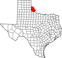 Location in the U.S. state of Texas | |
 Texas's location in the U.S. | |
| Existed | 1860-1896 |
| Named for | John Alexander Greer |
| Seat | Mangum |
| Population | |
| • (1890) | 5,336 |
Part of a series on the |
||||||||||||||
|---|---|---|---|---|---|---|---|---|---|---|---|---|---|---|
| History of Texas | ||||||||||||||
 | ||||||||||||||
| Timeline | ||||||||||||||
|
||||||||||||||
|
| ||||||||||||||
Greer County, a county created by the Texas legislature on February 8, 1860 (and named for John Alexander Greer, Lieutenant Governor of Texas), was land claimed by both Texas and the United States.
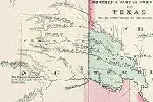
Origin of the dispute
The dispute arose from a map submitted with the Adams-Onís Treaty of 1819. The treaty stated that the boundary between the French claims on the north and the Spanish claims on the south was Rio Roxo de Natchitoches (Red River) until it reached the 100th meridian west as noted on John Melish's map published in 1818. The problem was that the 100th meridian on the Melish map was some 90 miles (140 km) east of the true 100th meridian and the Red River forked about 50 miles (80 km) east of the 100th meridian. Texas claimed the land south of the North Fork and the United States claimed the land north of the South Fork (later called the Prairie Dog Town Fork Red River).
United States vs. State of Texas
The dispute resulted in a lawsuit, which eventually wound up before the Supreme Court—no lower court having jurisdiction. The Court's opinion, in United States v. State of Texas 162 U.S. 1 (1896), issued on March 16, held that the land of some 1.5 million acres (6070 km²/2345 mi²) belonged to the United States. Following that ruling, on May 4, 1896, the land was officially assigned by Congress to Oklahoma Territory. The Greer County Homestead Law, passed just afterwards, gave the Texas settlers the 160 acres (647,000 m²) they were living on and the option to purchase an additional 160 acres (647,000 m²) for $1.00 per acre ($247/km²).
Legacy
When Oklahoma became the 46th U.S. state (November 16, 1907), old "Greer County" was divided into Greer, Jackson, and part of Beckham counties. Harmon County was created May 22, 1909 by a vote of the people from a portion of Greer County, Oklahoma.
See also
- Oklahoma
- Greer County, Oklahoma
- Harmon County, Oklahoma
- Jackson County, Oklahoma
- Beckham County, Oklahoma
- Texas Panhandle
- Childress County, Texas
- Collingsworth County, Texas
- Hardeman County, Texas
- List of extinct United States counties
References
- Estill-Harbour, Emma, Ph.D. "Greer County", Chronicles of Oklahoma 12:2 (June 1934) 145-162 (retrieved August 16, 2006).
External links
- Greer County from the Handbook of Texas Online
Coordinates: 34°42′N 99°42′W / 34.7°N 99.7°W