Prairie Dog Town Fork Red River
| Prairie Dog Town Fork Red River | |
|---|---|
|
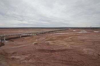
Prairie Dog Town Fork in Armstrong County | |
|
Map of Red River and tributaries | |
| Country |
|
| Basin | |
| Main source |
Randall County, Texas 3,471 ft (1,058 m) 35°00′09″N 101°54′10″W / 35.00250°N 101.90278°W |
| River mouth |
Harmon County, Oklahoma 1,545 ft (471 m) 34°34′41″N 99°58′00″W / 34.57806°N 99.96667°WCoordinates: 34°34′41″N 99°58′00″W / 34.57806°N 99.96667°W |
| Alt. difference | 1,926 ft (587 m) |
| River system | Red River |
| Basin size | 7,630 sq mi (19,800 km2) |
| Physical characteristics | |
| Length | 120 mi (190 km) |
| Features | |
| Tributaries |
|
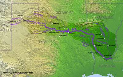
Prairie Dog Town Fork Red River is a sandy-braided stream about 120 mi (193 km) long, formed at the confluence of Palo Duro Creek and Tierra Blanca Creek, about 1.8 mi (2.9 km) northeast of Canyon in Randall County, Texas, and flowing east-southeastward to the Red River about 1 mi (2 km) east of the 100th meridian, 8 mi (13 km) south-southwest of Hollis, Oklahoma.[1]
Geography
The Prairie Dog Town Fork Red River is the southernmost of two major forks which form the headwaters of the Red River. It begins as an ephemeral stream on the level surface of the Llano Estacado in Randall County, about 4 mi (6 km) northeast of Canyon, Texas. The stream initially runs northeastward then southeastward across Randall County, flowing through Palo Duro Canyon where it is fed by springs, providing a base flow that is often increased significantly by runoff from rainstorms. It provides the water for Lake Tanglewood and River Falls prior to flowing through the Palo Duro Canyon State Park.[2] The stream continues in a southeasterly direction through southern Armstrong and northeastern Briscoe County where it exits Palo Duro Canyon and starts across the rolling red-bed country of central Hall County, where it merges with the Little Red River. The stream continues across Hall and Childress counties, merging with Buck Creek and forming the Red River proper, 8 mi (13 km) south-southwest of Hollis, Oklahoma.[1] When the Prairie Dog Town Fork crosses the 100th meridian at the eastern edge of Childress County, Texas, its south bank becomes the state boundary between Texas and Oklahoma.[3]
Proper name
According to a 1959 decision by the United States Board on Geographical Names, this main tributary of the Red River is properly called the Prairie Dog Town Fork Red River, and should not be called the Prairie Dog Town Fork of the Red River, Prairie Dog Town Fork of Red River, or the South Fork of the Red River.[1]
See also
- Adams–Onís Treaty
- Double Mountain Fork Brazos River
- Ephemerality
- Little Red River (Texas)
- Llano Estacado
- Washita River
- Palo Duro Canyon
- Pease River
- Salt Fork Red River
- List of rivers of Texas
References
- 1 2 3 United States Board on Geographical Names. 1960. Decisions on Geographical Names in the United States and Puerto Rico, Decisions rendered in May, June, July, and August, 1959, Decision list no. 5903, United States Department of the Interior, Washington DC, p. 51.
- ↑ Brune, G.M. 1981. Springs of Texas. Fort Worth, TX: Branch-Smith, p. 377-380.
- ↑ "Prairie Dog Town Fork of the Red River". Handbook of Texas Online. Retrieved 2010-02-26.
External links
- U.S. Geological Survey Geographic Names Information System: Prairie Dog Town Fork Red River
- Prairie Dog Town Fork Red River from the Handbook of Texas Online
- Photos of the Llano Estacado