Grooverville, Georgia
Groovervile is an unincorporated community in Brooks County, Georgia, United States. It was once known as Key and was located at the crossing of the Thomasville and Madison and Sharpe's Store Road, which was in Thomas County prior to the creation of Brooks County from Lowndes and Thomas County in 1858.
Grooverville was incorporated on December 8, 1859 (per the Department of Transportation's General Highway Map of Brooks County, dated 1980). The charter of Grooverville was terminated by an act of the Georgia Legislature effective July 1, 1995, as codified in the Georgia Code Section 36-30-7. Since then, Grooverville has been granted status as Grooverville Historic Township by State of Georgia, Department of Community Affairs.
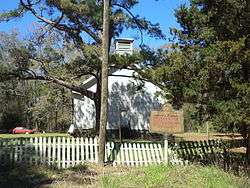
Grooverville Methodist Church and Liberty Baptist Church, the later listed on the National Register of Historic Places in 2013, are located in the area.
Geography
Grooverville is located at 30°43′44″N 83°42′54″W / 30.72889°N 83.71500°W (30.729141, -83.715055).[1]
It is a circular area 1.25-mile (2.01 km) radius from the crossing of Liberty Church Road and Grooverville Road: 4.9 square miles (13 km2). It is located approximately 11 miles (18 km) west-southwest of Quitman.
References
- ↑ "US Gazetteer files: 2010, 2000, and 1990". United States Census Bureau. 2011-02-12. Retrieved 2011-04-23.
Municipalities and communities of Brooks County, Georgia, United States | ||
|---|---|---|
| Cities | 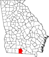 | |
| Communities | ||
| Footnotes | ‡This populated place also has portions in an adjacent county or counties | |