Guarapari
| Guarapari | ||
|---|---|---|
| Municipality | ||
| The Municipality of Guarapari | ||
|
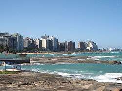
A view of Guarapari | ||
| ||
| Nickname(s): "Barra" | ||
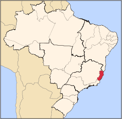
 Location of Guarapari in the State of Espírito Santo | ||
| Coordinates: 20°39′S 40°30′W / 20.650°S 40.500°W | ||
| Country |
| |
| Region | Southeast | |
| State |
| |
| Founded | 1679 | |
| Government | ||
| • Mayor | Orly Gomes (DEM) | |
| Area | ||
| • Total | 592.231 km2 (228.662 sq mi) | |
| [1] | ||
| Elevation | 15 m (49 ft) | |
| Population (2013) | ||
| • Total | 116,278 | |
| • Density | 200/km2 (510/sq mi) | |
| [2] | ||
| Time zone | UTC-3 (UTC-3) | |
| HDI (2000) | 0.731 – high[3] | |

Guarapari is a coastal town of Espírito Santo, Brazil, a popular tourist destination.
Location
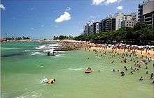
Guarapari is a part of Greater Vitoria, 47 km south of the state capital Vitória. Its population is 116,278 (2013) and its area is 592 km². It is a well-known tourist destination, known for its curving white sand beaches backed by commercial development. With its heavily built-up coastline like Vila Velha and Vitória, it caters heavily to seasonal tourists, and consequently has quite a dramatic seasonal population fluctuation.
The municipality contains the 953 hectares (2,350 acres) Concha D'Ostra Sustainable Development Reserve, established in 2003 to protect the mangroves of the Bay of Guarapari.[4] It also contains the 1,500 hectares (3,700 acres) Paulo César Vinha State Park, which protects an area of dunes, lagoons and marshes along the Atlantic shore.[5] Formerly called the Setiba nature reserve, it is a pristine example of a coastal ecosystem and important for local turtle and bird populations.
History
The municipality has had European presence since 1585 when Jesuit missionaries built a small chapel and dug a well. Guarapari beach has an extremely high level of background radiation. Some spots on the beach have readings of 175 mSv per year (20μSv/h).[6][7] In the city radiation levels are far lower, a study among 320 inhabitants showed an average received dose of 0.6 µSv/h, corresponding to 5.2 mSv per year.[8] Along a roughly 500-mile portion of Brazil's Atlantic coast that runs from north of Rio de Janeiro up to the region south of Bahia, the sands of old beaches are naturally radioactive. Sea waves pound coastal mountains rich in monazite, a phosphate of rare earth metals containing uranium and thorium.[9][10]
References
- ↑ IBGE -
- ↑ IBGE 2013 statistics
- ↑ UNDP
- ↑ RDS de Concha D'Ostra (in Portuguese), IEMA: Instituto Estadual de Meio Ambiente e Recursos Hídricos, retrieved 2016-10-27
- ↑ Parque Estadual Paulo César Vinha (in Portuguese), IEMA: Instituto Estadual de Meio Ambiente e Recursos Hídricos, retrieved 2016-10-26
- ↑ National Center for Biotechnology Information -
- ↑ Health Research Foundation, Japan -
- ↑ International_Radiation_Protection_Association -
- ↑ Industrias Nucleares do Brasil -
- ↑ Health Research Foundation (Japan) -
External links
 Guarapari travel guide from Wikivoyage
- Images Google Maps of Guarapari
- Guarapari
- Guarapari Info (in Portuguese)
- Rent Season - Guarapari (in Portuguese)
- Guarapari - History and Tips (in Portuguese)
Capital: Vitória | ||||||||||||||||
| Mesoregion Central |
|  | ||||||||||||||
| Mesoregion Litoral Norte |
| |||||||||||||||
| Mesoregion Noroeste |
| |||||||||||||||
| Mesoregion Sul |
| |||||||||||||||