Gunung Kidul Regency
| Gunungkidul Regency Kabupaten Gunungkidul | ||
|---|---|---|
| Regency | ||
|
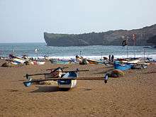
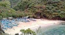
Baron Beach, one of the many beaches in Gunungkidul Regency | ||
| ||
| Nickname(s): [Thousand Mount City] Kota Gunung Sewu,[Gathot City] Kota Gathot,[Cave City] Kota Goa,[Chalk Mount City] Kota Gunung Kapur | ||
| Motto: Dhaksinarga Bhumikarta | ||
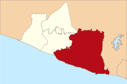 Gunungkidul Regency in Special Region of Yogyakarta | ||
| Country | Indonesia | |
| Special Administrative Region | Yogyakarta | |
| Capital | Wonosari | |
| Government | ||
| • Regent | Hj. Badingah | |
| Area | ||
| • Total | 1,485.36 km2 (573.50 sq mi) | |
| Population (2014) | ||
| • Total | 702,104 | |
| • Density | 470/km2 (1,200/sq mi) | |
| Time zone | WIB (UTC+7) | |
| Post Code | 55800 | |
| Area code(s) | 0274 | |
| Website | www.gunungkidulkab.go.id | |
Gunungkidul Regency is a regency in the southeast part of the province of Yogyakarta Special Region, Indonesia. The regency (the name of which means South Hills in Javanese) is bordered by the city of Yogyakarta to the north west, Bantul Regency to the west, Sleman Regency to the north west and the Indian Ocean to the south.
The southern coastal of Gunungkidul is rough and wild but exotic with several beautiful beaches: Baron, Kukup, Krakal, Drini, Sepanjang, Sundak, Siung Beach, Wediombo and Sadeng. Some of these beaches provide fresh fish and other sea product supplied by local fisherman. The most notable is Baron beach. There is a park next to the beach surrounded by seafood restaurants and hostels. There is a fresh fish market in the east side of the beach. On the west side, a river flows out from an almost sea-level cave on the side of western ridge. The beach itself is khaki-colored and sprawled with traditional fishermens' boat. Beside the main beach there is a kilometre of almost untouched white sand beach lying beyond its eastern ridge. It can be reach by small hike; there is a rest area with a beautiful view on top of the eastern hill.
There are also tourist sites to visit near the beach area of Parangtritis which is located on the border of the Kidul and Bantul districts. There are some temples, springs, and underground rivers in the village of Girijati near Parangtritis.[1]
The Gunungkidul area in earlier times was heavily forested. However most of the teak forests have now been removed and many reforestation projects occur on the western edge of the regency. The regency has been subject to extensive drought and famine within the last hundred years. Water shortages and poverty remain serious problems in the region.[2]
General Condition
Geography
Gunung Kidul Regency is in a karst region. This leads to difficult geography for farmers and contributes to considerable poverty in the area because of water shortages.[3] Much of the Regency is included in the Mount Sewu (literally "thousand mountains") collection of limestone hills which stretches across parts of southern Java from parts of Kebumen Regency in the west near the border with West Java across to close to the city of Malang in East Java. The Menaroh Hills in the area south of Yogyakarta in Kulon Progo Regency, for example, are part of this series of limestone hills.[4]
Caves
The limestone hills are reported to contain hundreds of caves. These are classified locally as vertical caves (known as luweng in Javanese) and horizontal caves. Jomblang cave (Luweng Jomblang) and Grubug Cave (Luwung Grubug) located in the Semanu subdistrict in Kulon Progo, as well as other caves in the area, are well-known to local caving (speleological) groups. Some of the caves are quite long; Cerme cave, for example, has an entrance in Bantul Regency and stretches for quite a distance eastward into Panggang subdistrict in Gunung Kidul Regency.[4]
Prehistoric
From archaeological findings, the area of Gunungkidul thought to have been inhabited by humans ( Homo sapiens ) from 700 thousand years ago. [5] Many find the instructions of human existence found in caves and niches in karst of Gunungkidul , especially in Ponjong sub-district. The human propensity Gunung occupy the time it caused most of the lowland in Yogyakarta is still flooded.[6] The arrival of the first humans in Gunungkidul occurred at the end of the Pleistocene period . At that time , the human race Australoid migrated from the Pegunungan Sewu in Pacitan, East Java passing Wonogiri karst valleys, Central Java until it reaches the southern coast of Gunungkidul through ancient, Bengawan Solo.
Borderline
- North ; Klaten, Sukoharjo, Sleman
- West ; Imogiri, Pundong, Dlingo, Piyungan
- South ; Indian Ocean
- East ; Wonogiri
Culture
Gunung Kidul Regency is located in the limestone uplands of Java, thus soils are not very good for growing rice. Cassava replaced rice in this area. Some famous Gunung Kidul cuisine includes thiwul, gathot (both are cassava-based food), and a delicacy called walang goreng (fried grasshopper)
Topography
North Zone
North Zone called Agung Batur region with an altitude of 200 m - 700 m above sea level. The situation is hilly, there are sources of ground water depth of 6m - 12m from the ground. Latosol soil types dominated by volcanic and sedimentary parent hurricane stones. This area includes the District Patuk , Gedangsari , Nglipar , Ngawen , Semin , and the northern part of the District Ponjong.
Central Zone
Central Zone called Ledok Wonosari development, with an altitude of 150 m - 200 m above sea level. The soil type is dominated by mediterranean association with the red and black grumosol limestone. So although it's long dry season , the water particles are still able to survive . There is a river on the land. Ground water depth ranging between 60 m - 120 m below the ground surface . This area includes the District Playen , Wonosari , Karangmojo , Ponjong the central and northern parts Semanu
South Zone
South Zone called Pegunungan Seribu development area (Duizon gebergton or Zuider gebergton) , with an altitude of 0 m - 300 m above sea level. Constituent bedrock is limestone with characteristic conical hills (Conical limestone) and the karst area . In this region often found underground river. The South Zone includes District Saptosari , Paliyan , Girisubo , Tanjungsari , Kecamatan Tepus, Rongkop , Purwosari , Panggang, Ponjong the south , and the southern part Semanu.
Climatology
Gunung Kidul regency including tropical area, the topography of a region dominated by karst region area . The southern region is dominated by karst region, that are numerous natural caves and underground rivers flowing. Under these conditions cause the condition of the land in the southern area which resulted in less fertile agricultural cultivation in this region is less than optimal. Gunungkidul climatological conditions generally exhibit the following conditions:
- The average rainfall in 2010 amounted to 1954.43 mm/year with the number of rainy days an average of 103 days/year. Wet months 7 months, while the dry months range from 5 months. GunungKidul north region has the highest rainfall over central and southern regions . Gunungkidul southern region has the most rain beginning late
- Temperatures daily average of 27.7°C , minimum temperature of 23.2°C and a maximum temperature of 32.4°C.
- Relative humidity ranging between 80% - 85%, not too influenced by the high places, but more influenced by the seasons.
Heirloom
Tombak Kyai Marga Salurung
Tombak Kyai Marga Salurung is one of heirloom gift from the King of Yogyakarta, Hamengkubuwono X on Sunday, May 27, 2001 , when the Celebration of 170th Anniversary of Gunungkidul Regency. Spear heirloom that has a new dhapur cekel, warangka kajeng sanakeling symbolize that the district government of Gunungkidul still has a major commitment to achieve lofty ideals are deeply rooted and always siding with the people . The leaders and the people have the attitude or the direction salurung approval , accord , saiyeg - saeka- kapti in the corridors of democracy , which means heavy hands make light work , conscious of their rights, but also respect the rights of others and know for certain obligations.
UNESCO Geopark
Gunung Kidul Regency and the nearby Imogiri area (in Bantul Regency) and Pacitan Regency (East Java Province) is being promoted by the Indonesia government to be a UNESCO Geopark, due to their unique and scenic karst landscape. An accessor from UNESCO has visited 4 areas in July 2014. These include:[7]
- Pindul Cave, in tectonic active area, the cave and the Gunung Kidul Karst Region give more variative karst stone/land, if it is compared with Gunung Sewu area in Pacitan and Wonogiri
- Nglanggeran Primeval Volcano
- Bobung Tourism Village
- Siung Beach
.jpg)
As a karst region Gunung Kidul Regency has many caves, some of which have underground rivers. At least two of them (Pindul Cave in the Bejiharjo area and Kalisuci Cave in the Semanu area) are regarded as tourist sites[8] where tubing activities can be carried on.[9]
Nglanggeran primeval volcano in the Patuk area is only 600 meters high but there are excellent views from the peak to the north towards Mount Merapi and to the south across to the coast of Java. Scattered giant granite and andesit rock formations called "watu wayang" (puppet rocks) are found at the Mt Nglanggeran area as well as a nearby man-made lake. It takes around 3 hours to hike from the Pendopo Kali Song entrance point to the peak.[10]
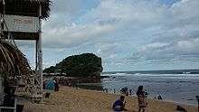
Siung Beach Bay is about 300 meters length, but swimming is prohibited because of dangerous rocks and severe waves. The cliff surrounding the beach, with over 200 tracks, is suitable for rock climbing.[11]
200 meters east of Siung Beach there is a 10-meter Jogan Tide Fall in Tepus district which is 70 kilometers from Yogyakarta in 2 hours drive. Rainy season is the best time to see the Jogan Tide Fall, because in dry season the water level is low.[12]
Administrative districts

Gunung Kidul Regency is divided into 18 districts (kecamatan), listed below with their populations at the 2010 Census:[13]
- Panggang (26,509)
- Purwosari (19,361)
- Paliyan (29,083)
- Sapto Sari (34,270)
- Kecamatan Tepus (31,889)
- Tanjungsari (25,698)
- Rongkop (26,901)
- Girisubo (22,188)
- Semanu (51,737)
- Ponjong (49,803)
- Karangmojo (48,768)
- Wonosari (78,747)
- Playen (54,492)
- Patuk (30,336)
- Gedang Sari (35,265)
- Nglipar (29,687)
- Ngawen (31,622)
- Semin (49,026)
Regent
- Mas Tumenggung Pontjodirjo
- Raden Tumenggung Prawirosetiko
- Raden Tumenggung Suryokusumo
- Raden Tumenggung Tjokrokusumo
- Raden Tumenggung Padmonegoro
- Raden Tumenggung Danuhadiningrat
- Raden Tumenggung Mertodiningrat
- K.R.T. Yudodiningrat
- K.R.T. Pringgodiningrat
- K.R.T. Djojodiningrat
- K.R.T. Mertodiningrat
- K.R.T. Dirjodiningrat
- K.R.T. Tirtodiningrat
- K.R.T. Suryaningrat
- K.R.T. Labaningrat
- K.R.T. Brataningrat
- K.R.T. Wiraningrat
- Prawirosuwignyo
- K.R.T. Djojodiningrat, B.A.
- Ir. Raden Darmakun Darmokusumo
- Drs. K.R.T. Sosrodiningrat
- Ir. Soebekti Soenarto
- K.R.T. Harsodingrat, B.A.
- Drs. K.R.T. Hardjohadinegoro (Drs. Yoetikno)
- Suharto, S.H.
- Prof. Dr. Ir. Sumpeno Putro, M.Sc.
- Hj. Badingah, S.Sos.
Potential Tourism
Beach
Kecamatan Tepus
Banyunibo, Busung, Jagang Kulon, Jogan, Klumpit, Lambor, Sundak, Ngetun, Ngondo, Nguluran, Ngungap, Pakundon, Sawahan, Siung Beach,[14] Ngandong, Seruni, Songlibeng, Watutogok, Weru, Timang Beach, Muncar, Slili, Pulang Sawal/Indrayanti, Kelosirat, PokTunggal
Tanjungsari
Baron, Kukup, Krakal, Drini, Parangracuk, Sepanjang, Sarangan, Watukodok
Girisubo
Krokoh, Sadeng, Wediombo
Panggang
Gesing, Grigak, Karangtelu, Kesirat, Nampu, Ngunggah
Saptosari
Butuh, Langkap, Ngobaran, Ngrenehan, Nguyahan, Torohudan
Purwosari
Klampok, Parangendog, Watugupit - Purwosari
Culture Tourism
- Pesanggrahan Gembirowati
- Pertapaan Kembang Lampir
- Petilasan Gunung Gambar
- Rasulan / Bersih Desa, Is an indigenous tradition that is held annually by the majority of the villages in Gunungkidul. theSymbol embodiment of a sense of gratitude to God. Usually performed traditional festivity, spoiling your appetite as well as the performing arts such as jathilan, reog and wayang kulit
Natural Tourism
- Gunung Nglanggeran, Patuk - An ancient volcano that is made up of older volcanic material . Presents a beautiful panorama.
- Telaga Suling/Bengawan Solo Purba -
- Lembah Karst Mulo/ Ngingrong
- Air Terjun Sri Gethuk - Dusun Menggoran, Bleberan, Playen
- Wonosadi Forestry and Gunung Gambar, Ngawen. Famous for its traditional music, Rinding Gumbeng.
- Wanagama Forestry - Banaran, Playen
- Kemuning Lake at Desa Kemuning, Patuk
- Luweng Sampang - Dusun Karangasem, Sampang, Gedangsari
- Embung Nglanggeran - Desa Nglanggeran, Patuk
- Nglangggeran Orchard around Embung Desa Nglanggeran, Patuk
- Bukit Indah - Hargodumilah, Patuk, Patuk
- Tahura Bunder - Bunder, Patuk
- Goa Pindul - Karangmojo
- Pakel - Semin, Gunungkidul
References
- ↑ Dalih Sembiring, 'A Girijati Getaway: Hidden Allures in South Yogyakarta', The Jakarta Globe, 25 October 2010.
- ↑ Oei Eng Goan, 'The Thinker: For Want of Water', The Jakarta Globe, 20 September 2011.
- ↑ Slamet Susanto, 'Ponijo: Sunny disposition keeps water flowing', The Jakarta Post, 16 August 2007.
- 1 2 'Sewu mountain, a paradise for cave explorers', The Jakarta Post, 30 June 2001.
- ↑ Kusuma M. Melacak Manusia Purba Gunung Kidul. Kompas daring. Edisi Minggu, 11 Oktober 2009. Diakses 15 Juni 2014
- ↑ Kompas - Melacak manusia purba Gunungkidul diakses pada 6 November 2009
- ↑ Hari Susmayanti (July 7, 2014). "Kristin Terkejut dengan Keindahan Gua Pindul".
- ↑ "Cave Tubing Kalisuci". Retrieved November 11, 2013.
- ↑ "Selamat Datang di website resmi desa Wisata Bejiharjo". Retrieved March 24, 2013.
- ↑ Diyah Hayu Rahmitasari, 'A piece of heaven on earth', The Jakarta Post, May 13, 2013.
- ↑ "Siung, Pantai Indah Bertembok Karang". May 15, 2012.
- ↑ "Pantai Jogan, Panorama Air Terjun Di Bibir Pantai". Retrieved August 29, 2014.
- ↑ Biro Pusat Statistik, Jakarta, 2011.
- ↑ Heri Cahyo (2015). "Pantai Siung, Pantai Sejuta Kenangan". kompasiana.com. Retrieved 13 January 2015.
External links
![]() Media related to Gunung Kidul at Wikimedia Commons
Media related to Gunung Kidul at Wikimedia Commons
Regencies and cities of the Special Region of Yogyakarta | ||
|---|---|---|
Capital: Yogyakarta | ||
| Regencies | ||
| Cities | ||
Coordinates: 7°58′00″S 110°36′09″E / 7.966680°S 110.602561°E