Hackforth
Coordinates: 54°20′11″N 1°37′36″W / 54.33644°N 1.62666°W
Hackforth is a small village and civil parish in the Hambleton district of North Yorkshire, England, about 4 miles (6 km) north of Bedale.[2] Nearby settlements include Langthorne and Crakehall. The pub is called the "Greyhound".

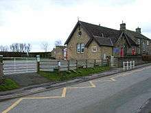
Hackforth and Hornby Church of England Primary School
References
- ↑ "Parish population 2011". Neighbourhood Statistics. Office for Nantional Statistics. Retrieved 29 July 2015.
- ↑ Ordnance Survey: Landranger map sheet 99 Northallerton & Ripon (Pateley Bridge & Leyburn) (Map). Ordnance Survey. 2013. ISBN 9780319231593.
External links
![]() Media related to Hackforth at Wikimedia Commons
Media related to Hackforth at Wikimedia Commons
This article is issued from Wikipedia - version of the 3/17/2016. The text is available under the Creative Commons Attribution/Share Alike but additional terms may apply for the media files.
