DL postcode area
Postcode district boundaries: Bing / Google
| Darlington postcode area | |
|---|---|
 DL | |
| Postcode area | DL |
| Postcode area name | Darlington |
| Post towns | 14 |
| Postcode districts | 17 |
| Postcode sectors | 67 |
| Postcodes (live) | 13,133 |
| Postcodes (total) | 16,036 |
| Statistics as at February 2012[1] | |
The DL postcode area, also known as the Darlington postcode area,[2] is a group of postcode districts around Barnard Castle, Bedale, Bishop Auckland, Catterick Garrison, Crook, Darlington, Ferryhill, Hawes, Leyburn, Newton Aycliffe, Northallerton, Richmond, Shildon and Spennymoor in England.
Coverage
The approximate coverage of the postcode districts:
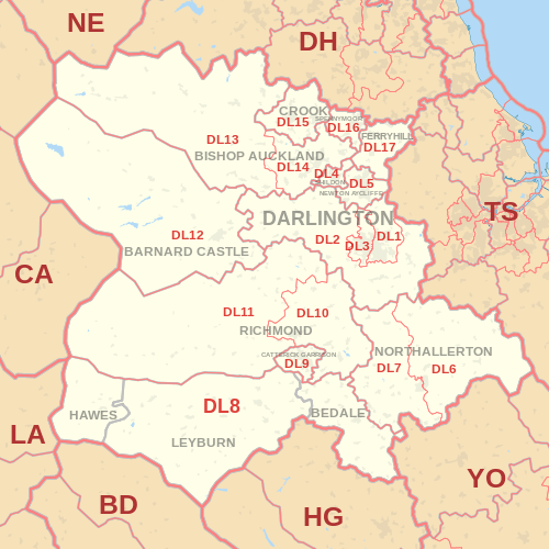
| Postcode district | Post town | Coverage | Local authority area |
|---|---|---|---|
| DL1 | DARLINGTON | Darlington East | Darlington |
| DL2 | DARLINGTON | Staindrop, Gainford & Darlington new estates | County Durham, Darlington |
| DL3 | DARLINGTON | Darlington West, Faverdale, Coatham Mundeville | Darlington |
| DL4 | SHILDON | Shildon | County Durham |
| DL5 | NEWTON AYCLIFFE | Newton Aycliffe & Heighington | County Durham |
| DL6 | NORTHALLERTON | Northallerton East & Ingleby Cross | North Yorkshire |
| DL7 | NORTHALLERTON | Northallerton West, Romanby, Leeming Bar | North Yorkshire |
| DL8 | BEDALE, HAWES, LEYBURN | Wensleydale & Bedale | North Yorkshire |
| DL9 | CATTERICK GARRISON | Catterick Garrison | North Yorkshire |
| DL10 | RICHMOND | Richmond, Catterick, Brompton-upon-Swale & Scotch Corner | North Yorkshire |
| DL11 | RICHMOND | Swaledale, Reeth, Low Row & Arkengarthdale | North Yorkshire, Cumbria |
| DL12 | BARNARD CASTLE | Barnard Castle, Bowes & Middleton-in-Teesdale | County Durham |
| DL13 | BISHOP AUCKLAND | Stanhope, Frosterley, Wolsingham & Tow Law | County Durham, Cumbria |
| DL14 | BISHOP AUCKLAND | Bishop Auckland & Evenwood | County Durham |
| DL15 | CROOK | Crook & Willington | County Durham |
| DL16 | SPENNYMOOR | Spennymoor | County Durham |
| DL16 | FERRYHILL | non-geographic[3][4] | |
| DL17 | FERRYHILL | Ferryhill, Chilton, Cornforth & Bishop Middleham | County Durham |
| DL98[5] | DARLINGTON | non-geographic |
Map
See also
References
- ↑ "ONS Postcode Directory Version Notes" (ZIP). National Statistics Postcode Products. Office for National Statistics. February 2012. Table 2. Retrieved 21 April 2012. Coordinates from mean of unit postcode points, "Code-Point Open". OS OpenData. Ordnance Survey. February 2012. Retrieved 21 April 2012.
- ↑ Royal Mail, Address Management Guide, (2004)
- ↑ "Non Geographic Codes" (PDF). Royal Mail Address Management Unit. July 2012. Archived from the original (PDF) on 16 September 2012. Retrieved 20 December 2012.
- ↑ "New sectors and localities to 14 December 2012" (PDF). Royal Mail Address Management Unit. 20 December 2012. Archived from the original (PDF) on 2 February 2015. Retrieved 20 December 2012.
- ↑ "New sectors and localities to 17 August 2012" (PDF). Royal Mail Address Management Unit. 17 August 2012. Archived from the original (PDF) on 16 September 2012. Retrieved 21 August 2012.
External links
This article is issued from Wikipedia - version of the 12/4/2016. The text is available under the Creative Commons Attribution/Share Alike but additional terms may apply for the media files.