Hadrian's Wall Path
| Hadrian's Wall Path | |
|---|---|
|
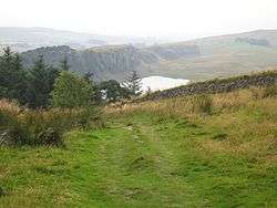
Crag Lough, near Steel Rigg on the Path. Photo taken from Hotbank Crags. | |
| Length | 84 mi (135 km) |
| Location | England: Tyne and Wear, Northumberland, Cumbria |
| Designation | National Trail |
| Trailheads |
Wallsend Bowness-on-Solway |
| Use | Hiking |
| Elevation | |
| Highest point | 345 m (1,132 ft), Whinshields Crags |
| Hiking details | |
| Sights | Hadrian's Wall World Heritage Site |
The Hadrian’s Wall Path is a long distance footpath in the north of England, which became the 15th National Trail in 2003. It runs for 135 km (84 mi), from Wallsend on the east coast of England to Bowness-on-Solway on the west coast.[1] For most of its length it is close to the remains of Hadrian's Wall, the defensive wall built by the Romans on the northern border of their empire. This is now recognised as a World Heritage Site.
Path description
Though muddy in places, the walking is relatively easy, as the highest point on the path is only 345 m (1130 ft) high[2] and for much of its length the path is more or less flat. Most of the Wall runs through remote countryside but there are sections that pass through the cities and suburbs of Newcastle and Carlisle. The path is well signposted. For most of the walk there are many signs of human activity, and many other walkers in summer. Though there are villages and farms near to the path, there are not many places to buy food and drink, especially in the middle sections. The section between Chollerford and Walton is the highest and wildest part of the path; it is also where the Wall is most visible, and includes several important Roman forts.
This itinerary breaks the 84-mile (135 km) walk into six reasonable stages, and is presented from east to west (against the prevailing wind).
- Wallsend to Heddon-on-the-Wall – 15 miles (24 km) long.
The path starts by the Swan Hunter shipyard. Before starting the walk it is worth visiting the nearby site of the Roman fort of Segedunum. Most of this section runs through urban areas, including through the centre of Newcastle upon Tyne, and along the banks of the Tyne. Only the last part, leading to Heddon-on-the-Wall, is in open countryside. There are occasional glimpses of the Wall.
- Heddon-on-the-Wall to Chollerford – 15.5 miles (25 km) long.
This section is almost entirely through open countryside. The Wall is occasionally visible and the Vallum (earthwork) is frequently visible on the south side.
- Chollerford to Steel Rigg - 12 miles (19 km) long.

The Roman fort of Chesters is close to the start of this section. The path starts to rise now and the countryside becomes moorland, rather than farmland. Much more of the Wall is visible and parts of it run along the edge of crags, giving superb views over the open countryside to the north. The path passes the Roman fort at Vercovicium (Housesteads), which has been extensively restored and contains much of interest. The Pennine Way long-distance path branches off north just after this.
- Steel Rigg to Walton - 16.25 miles (26 km) long.
This is another section across open countryside with the Wall occasionally visible. The Roman fort at Birdoswald has a museum. The Pennine Way long distance path joins the Hadrian’s Wall Path near the village of Greenhead. As the path approaches Walton, Lanercost Priory is a short walk to the south. Much of the Priory was built with stones taken from the Wall.
- Walton to Carlisle – 11 miles (18 km) long.
Here the path returns to farmland and crosses the M6 motorway. Part of the path is alongside the River Eden, passing through a pleasant park and over a large footbridge.
- Carlisle to Bowness-on-Solway – 14.75 miles (24 km) long.
The first part of this section is rather bare but the walking improves once the path gets beyond the outskirts of Carlisle. Most of the path runs alongside either the River Eden or the Solway Firth. There is nothing of the Wall to be seen but the walking is open and pleasant. The path ends in the village of Bowness-on-Solway.
Access
Both Newcastle and Carlisle are on the UK national railway network. The start of the walk at Wallsend can be easily reached by taking a local train from Newcastle to the Wallsend Metro Station, and then walking a short distance. The Tyne Valley railway line runs between Newcastle and Carlisle, with stops at Wylam, Corbridge, Hexham, Haydon Bridge, Bardon Mill and Haltwhistle. For most of its length, the line is not within easy walking distance of the Wall. The Wall can also be easily accessed by car, bus or taxi.
There is a Hadrian's Wall bus (service AD122) which runs close to the Wall during the summer. The bus runs between Hexham, Chesters, Housesteads, Once Brewed, Vindolanda, Walltown and Haltwhistle approximately once an hour 0900 - 1700. The service runs daily until 27 September 2015.
See also
- Hadrian's Wall
- Coast to Coast Walk – a similar alternative, somewhat to the south, from St Bees to Robin Hood's Bay
- National Trails
- Long-distance footpaths in the United Kingdom
References
- ↑ "National Trails: Hadrian's Wall". The National Trails Website. Natural England. Retrieved 10 April 2010.
- ↑ "National Trails: Hadrian's Wall". The National Trails Website. Natural England. Retrieved 10 April 2010.
- Hadrian's Wall Path by Anthony Burton. Published by Aurum Press in 2003. ISBN 1-85410-893-X.
Further reading
- Walk Hadrian's Wall: The 84 Mile Route from Bowness-on-Solway to Wallsend (2007) by Brian Smailes. Challenge Publications ISBN 978-1-903568-40-8
External links
| Wikimedia Commons has media related to Hadrian's Wall Path. |
- Hadrian's Wall Path at National Trails website
- Aerial photographs of Hadrian's Wall
- Page featuring the Hadrian's Wall Walk route in 2 mile sections
Coordinates: 55°01′53″N 2°07′40″W / 55.03137°N 2.12791°W