Hale Glacier
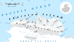
Hale Glacier (72°13′S 100°33′W / 72.217°S 100.550°WCoordinates: 72°13′S 100°33′W / 72.217°S 100.550°W) is a glacier about 6 nautical miles (11 km) long, located just east of Mount Simpson on Thurston Island, Antarctica, and flowing southwest to the Abbot Ice Shelf in Peacock Sound. It was delineated from air photos taken by U.S. Navy Squadron VX-6 in January 1960, and was named by the Advisory Committee on Antarctic Names for Lieutenant Bill J. Hale, U.S. Navy, a helicopter pilot aboard the USS Burton Island (AGB-1) who made exploratory flights to Thurston Island in February 1960.[1]
Maps
- Thurston Island – Jones Mountains. 1:500000 Antarctica Sketch Map. US Geological Survey, 1967.
- Antarctic Digital Database (ADD). Scale 1:250000 topographic map of Antarctica. Scientific Committee on Antarctic Research (SCAR), 1993–2016.
References
- ↑ "Hale Glacier". Geographic Names Information System. United States Geological Survey. Retrieved 2012-05-16.
![]() This article incorporates public domain material from the United States Geological Survey document "Hale Glacier" (content from the Geographic Names Information System).
This article incorporates public domain material from the United States Geological Survey document "Hale Glacier" (content from the Geographic Names Information System).