Mount Simpson
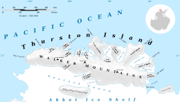
Map of Thurston Island.
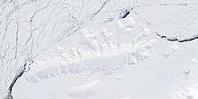
Satellite image of Thurston Island.
Mount Simpson (72°8′S 100°32′W / 72.133°S 100.533°WCoordinates: 72°8′S 100°32′W / 72.133°S 100.533°W) is a peak of the Walker Mountains, rising just west of the head of Hale Glacier on Thurston Island. It was first mapped from air photos taken by U.S. Navy Operation Highjump in December 1946. It was named by the Advisory Committee on Antarctic Names (US-ACAN) for Lieutenant B.L. Simpson, Jr., of U.S. Navy Squadron VX-6, a pilot of the P2V Neptune airplane which took additional air photos of the area in January 1960.
Maps
- Thurston Island – Jones Mountains. 1:500000 Antarctica Sketch Map. US Geological Survey, 1967.
- Antarctic Digital Database (ADD). Scale 1:250000 topographic map of Antarctica. Scientific Committee on Antarctic Research (SCAR). Since 1993, regularly upgraded and updated.
![]() This article incorporates public domain material from the United States Geological Survey document "Mount Simpson" (content from the Geographic Names Information System).
This article incorporates public domain material from the United States Geological Survey document "Mount Simpson" (content from the Geographic Names Information System).
This article is issued from Wikipedia - version of the 1/31/2016. The text is available under the Creative Commons Attribution/Share Alike but additional terms may apply for the media files.