Hang Hau
| Hang Hau | |||||||||||
 | |||||||||||
| Traditional Chinese | 坑口 | ||||||||||
|---|---|---|---|---|---|---|---|---|---|---|---|
| |||||||||||
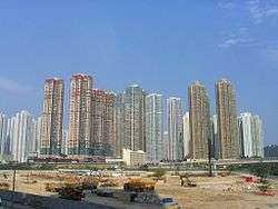
Hang Hau (Chinese: 坑口) is a residential area in Tseung Kwan O, Sai Kung, New Territories, Hong Kong. It is located at the eastern edge of the Tseung Kwan O New Town. Most of the land was reclaimed from Ap Chai Wan (now Shui Bin Village (水邊村)).

History
The earliest traceable history referring to Hang Hau was in the 19th century. It was an agricultural and fishing village. Hang Hau got its name from a large water channel near Mang Kung Uk (孟公屋) that led to the sea. In days gone by, Hang Hau was on the sea front, facing Junk Bay. Many of the village names in Hang Hau reflect this – Shui Bin Village (水邊村) means Waterside Village, for example.
On 2 October 1957, Hang Hau Rural Committee was established. The rural committee was to serve the indigenous inhabitants in Hang Hau Village, Shui Bin Village, Tin Ha Wan Village, Yau Yue Wan Village, Tseng Lan Shue, Tai Po Tsai, Mang Kung Uk and Po Toi O.[1]
Between the 1960s and 1980s, Hang Hau was a large ship scrapyard area. Since there was a ferry from Junk Bay to Island East Hong Kong, Hong Kong Oxygen Company started building factory in Hang Hau. Manufacturing business and trading service were thus established.
Long before the development of Tseung Kwan O New Town, Hang Hau was near settlements such as Hang Hau Village, Boon Kin Village and Tin Ha Wan Village. Most of the Villages were relocated at the current site near the Tseung Kwan O Hospital, which were moved after the new town's development. Now, about two-thirds of Hang Hau is on reclaimed land, and the sea is far away.
There has been a proposal to build Hang Hau New Town. It was considered because it is near the urban area, but it was put aside owing to the high cost of reclaiming the deep Junk Bay.
Housing
Hang Hau is developed over hundred years, many indigenous three storey village houses still can be found in the eastern edge of Hang Hau. Nowadays, Hang Hau is fully packed with private and public estates owing to the development of Tseung Kwan O New Town.
Home Ownership Scheme Estates
Private Sector Participation Scheme (PSPS) Estates
Public Estates
Private Estates
- East Point City
- Maritime Bay
- Residence Oasis
- La Cite Noble
- Nan Fung Plaza
Villages
- Boon Kin Village
- Hang Hau Village
- Shui Bin Village
- Tin Ha Wan Village
Infrastructures
Civil Facilities
- Po Ning Road General Outpatient Clinic
- Sai Kung Tseung Kwan O Government Complex
- Tseung Kwan O Hospital
Recreations
- Hang Hau Sports Centre
- Hang Hau Man Kuk Lane Park
- Tseung Kwan O Sports Ground
Shopping Malls
- East Point City
- TKO Gateway
- Nan Fung Plaza
- The Lane (MTR Malls)
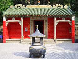
Temple
- Hang Hau Tin Hau Temple
Church
- St Andrew's Church
Institutes
Primary Schools
- Assembly of God Leung Sing Tak Primary School
- PLK Fung Ching Memorial Primary School
- Tseung Kwan O Government Primary School
- Yan Chai Hospital Chan Iu Seng Primary School
Secondary Schools
- Catholic Ming Yuen Secondary School
- H.K.M.L.C. Queen Maud Secondary School
- PLK Ho Yuk Ching (1984) College
Transportation
| Transportation details | |||||||
|---|---|---|---|---|---|---|---|
|
See also
| Wikimedia Commons has media related to Hang Hau. |
References
Coordinates: 22°19′N 114°16′E / 22.317°N 114.267°E