Harrachov
| Harrachov | ||
| Town | ||
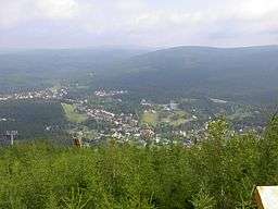 Panoramic view | ||
|
||
| Country | Czech Republic | |
|---|---|---|
| Region | Liberec | |
| District | Semily | |
| Commune | Tanvald | |
| Elevation | 665 m (2,182 ft) | |
| Coordinates | CZ 50°46′23″N 15°25′44″E / 50.77306°N 15.42889°ECoordinates: CZ 50°46′23″N 15°25′44″E / 50.77306°N 15.42889°E | |
| Area | 36.63 km2 (14.14 sq mi) | |
| Population | 1,696 | |
| Density | 46/km2 (119/sq mi) | |
| Founded | 17th century | |
| Mayor | Eva Zbrojová | |
| Timezone | CET (UTC+1) | |
| - summer (DST) | CEST (UTC+2) | |
| Postal code | 512 46 | |
  Location in the Czech Republic | ||
| Wikimedia Commons: Harrachov | ||
| Website: www.harrachov.cz www.harrachov.com/en | ||
Harrachov (Czech pronunciation: [ˈɦaraxof]; German: Harrachsdorf) is a town in Semily District, Liberec Region, in the northern Czech Republic, close to the border with Poland.
Geography
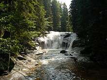
It is situated on the Mumlava River, a left tributary of the Jizera within the Krkonoše mountain range of the Sudetes, whose crest forms the Czech-Polish border near the Elbe river's source.
Located about 700 metres (2,300 ft) above sea level, Harrachov is one of the most popular Czech ski resorts including the internationally used Čerťák ski jumping hill (including flying hill); several winter sport events take place in Harrachov regularly. The whole region is of increasing importance for alpine tourism in Central Europe.
The European route E65 from Prague goes through the town and crosses the border to Szklarska Poręba in Poland near the village of Jakuszyce.
History
The first written reference dates back to the 17th century, when German settlers founded a village Dörfl there. In 1712 one Elias Müller from neighbouring Rýžoviště received the privilege by the local landowner Count Aloys Thomas Raimund Harrach to establish glassworks here, whereafter the adjacent settlement was renamed Harrachsdorf.

Since the end of 19th century Harrachsdorf has been known for its glass production, textile industry, and mining. At the beginning of the 20th century, industrial production was bolstered by the construction of a cog railway line between Bohemian Tannwald (Tanvald) via the Izera railway down to Silesian Hirschberg (present-day Jelenia Góra). The fact that the nearest stop at the Strickerhäuser hamlet was beyond the border of Austria-Hungary with the German Empire was not a major obstacle at that time.
After World War II, the Silesian lands in the north fell to the Republic of Poland according to the Potsdam Agreement and the border was closed. The German population was expelled and its property seized according to the Beneš decrees. In 1947 there were 1,553 people living in Harrachov.[1] Trains from Tanvald had to terminate in Kořenov, trains from Jelenia Góra were terminated in Jakuszyce (former Jakobsthal), on the northern side of the Novosvětský pass. Instead of opening the border, the Communist governments of Czechoslovakia and Poland arranged a territorial exchange. In 1959, Czechoslovakia acquired the area around former Strickerhäuser (Polish: Tkacze, present-day Mýtiny), which allowed it to extend the cog railway Tanvald-Kořenov to the outskirts of Harrachov, while the northern continuation decayed. Poland was compensated by land to the north at Mrtvý vrch.
Harrachov, joined by the originally independent villages Nový Svět (Neuwelt) and Rýžoviště, became a town in 1973. Cross border rail traffic was resumed in 2010.
References
- ↑ Columbia-Lippincott Gazeteer p. 760
External links
- Official website
- Map depicting the territory exchange between Czechoslovakia and Poland
- Map railway
- Official Tourists portal of Harrachov town
-
 Media related to Harrachov at Wikimedia Commons