Lomnice nad Popelkou
| Lomnice nad Popelkou | |||
| Town | |||
 | |||
|
|||
| Country | Czech Republic | ||
|---|---|---|---|
| Region | Liberec | ||
| District | Semily | ||
| Commune | Semily | ||
| Municipality | Lomnice nad Popelkou | ||
| Elevation | 478 m (1,568 ft) | ||
| Coordinates | CZ 50°32′N 15°23′E / 50.533°N 15.383°ECoordinates: CZ 50°32′N 15°23′E / 50.533°N 15.383°E | ||
| Area | 25.57 km2 (9.87 sq mi) | ||
| Population | 5,902 (2006-10-02) | ||
| Density | 231/km2 (598/sq mi) | ||
| First mentioned | 1232 | ||
| Mayor | Vladimír Mastník | ||
| Timezone | CET (UTC+1) | ||
| - summer (DST) | CEST (UTC+2) | ||
| Postal code | 512 51 - 512 63 | ||
  Location in the Czech Republic | |||
| Wikimedia Commons: Lomnice nad Popelkou | |||
| Statistics: statnisprava.cz | |||
| Website: www | |||

Lomnice nad Popelkou is a town in the Czech Republic, in the Liberec region.
History
Until 1918, the town was part of the Austrian monarchy (Austria side after the compromise of 1867), in the SEMILY - SEMIL district, one of the 94 Bezirkshauptmannschaften in Bohemia.[1]
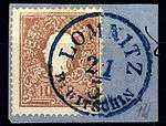
10 kreuzer in 1859 - Lomnitz bei Gitschin
The stamp shows Franz-Jozef I with the town name until 1896 LOMNITZ BEI GITSCHIN. Various bilingual names were used before 1900:
- LOMNITZ b.JICIN - LOMNICE u JICINA
- LOMNICE v JICINSKU - LOMNIC JICINERKREIS
- LOMNICE NAD POPELKOU - LOMNITZ A.D. POPELKA[2]
People from Lomnice nad Popelkou
- František Doubravský, choirmaster, organist and composer
- Karel Kodejška, ski jumper
- Cestmir Kozisek, ski jumper
- Roman Koudelka, ski jumper, represents the Lomnice nad Popelkou ski club.
- Hugó Meltzl, professor at University of Cluj and a founder of the field of comparative literature
References
- ↑ Die postalischen Abstempelungen auf den österreichischen Postwertzeichen-Ausgaben 1867, 1883 und 1890, Wilhelm KLEIN, 1967
- ↑ Klein N°2750.
External links
| Wikimedia Commons has media related to Lomnice nad Popelkou. |
This article is issued from Wikipedia - version of the 4/4/2016. The text is available under the Creative Commons Attribution/Share Alike but additional terms may apply for the media files.