Haskell-Baker Wetlands
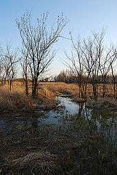

The Haskell-Baker Wetlands is a nature preserve and artificially sustained wetland,[1] spanning approximately 640 acres (2.6 km2) south of Lawrence, Kansas, United States. It is associated with the Wakarusa River and sustained by levees and flood controls built in the 1990s.[2]
Baker University owns 573 acres, the major portion of the site; Haskell Indian Nations University holds 27 acres, and the Kansas Department of Wildlife and Parks, and the University of Kansas hold 20 acres each. Baker University received its portion by a transfer from the United States Department of Health, Education, and Welfare (HEW) in 1968. This area was formerly used for farming by settlers and later was purchased by Haskell to teach farming to its students and be self sustaining. When the school's functions changed, the Department of Interior transferred the property to the HEW, which declared it surplus. It was transferred via the General Services Administration and regular process to Baker University.[2]
In 1969, the National Park Service declared the wetlands a National Natural Landmark. The wetlands support 413 documented species of vascular plant, 265 species of bird, and 61 additional vertebrate species.[2]
South Lawrence Trafficway alignment controversy
A proposal for completion of the South Lawrence Trafficway (SLT)—an extension of state highway K-10—through part of the Baker University campus would affect part of the wetlands. This realignment proposal generated fierce opposition.
A plan to mitigate for lost wetlands, loss of pedestrian access, and highway noise was approved by the US Army Corps of Engineers, Kansas Department of Transportation, and Federal Highway Administration.[3] Approximately 380 acres of man-made wetlands will be developed adjacent to the current site to fulfill this mitigation plan.[4]
See also
References
- ↑ Boyd, Roger. "Frequently Asked Questions". BakerU.edu. Baker University. Retrieved 2013-02-09.
- 1 2 3 Boyd, Roger. "Species Lists". BakerU.edu. Baker University. Retrieved 2014-07-31.
- ↑ "The Baker University Wetlands". SouthLawrenceTrafficway.org. Kansas Department of Transportation. 2010-12-28. Archived from the original on 2015-03-28. Retrieved 2015-05-19.
- ↑ Lawhorn, Chad (2011-06-03). "KDOT Commits $192 Million to Complete South Lawrence Trafficway". Lawrence Journal-World. The World Company. Retrieved 2011-08-11.
Further reading
- Activists rally for wetlands on KU campus – The Lawrence Journal-World
External links
Coordinates: 38°55′N 95°14′W / 38.917°N 95.233°W