Wollaston Lake, Saskatchewan
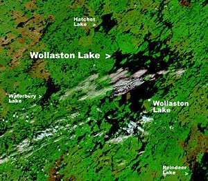

Wollaston Lake is a village on Wollaston Lake in the boreal forest of northeastern Saskatchewan, Canada.
The population centre comprises the northern settlement of Wollaston Lake, an unincorporated community in the Northern Saskatchewan Administration District, and the adjoining First Nations community of Wollaston Post, the administrative headquarters of the Hatchet Lake Dene First Nation band government.
Access is provided by Wollaston Lake Airport and Highway 905. The highway is on the west side of the lake and the community is on the east side. Access from the highway is provided by an ice road in the winter (November to June) and by the Wollaston Barge Ferry in the summer.
Demographics
The population of Wollaston Lake (the northern settlement) was 129 in 2012[1] and the population of Wollaston Post (Lac La Hache 220, IR, Saskatchewan) was 1,251 in 2011.[2] Together they form a community of 1,380 residents.
Wollaston Post statistics
| Canada census – Wollaston Lake, Saskatchewan community profile | |||
|---|---|---|---|
| 2011 | 2006 | ||
| Population: | 1,251 (+26.6% from 2006) | 953 (-3.2% from 2001) | |
| Land area: | 110.87 km2 (42.81 sq mi) | 107.95 km2 (41.68 sq mi) | |
| Population density: | 11.3/km2 (29/sq mi) | 8.8/km2 (23/sq mi) | |
| Median age: | 20.1 (M: 20.9, F: 19.9) | 19.4 (M: 19.7, F: 19.3) | |
| Total private dwellings: | 244 | 196 | |
| Median household income: | |||
| References: 2011[3] 2006[4] | |||
Hatchet Lake Dene Nation
Wollaston Post is the administrative centre of the Hatchet Lake Dene Nation. The First Nations band government had a total registered membership of 1,760 in January 2015 with 1,369 members residing on-reserve and 391 members residing at locations off-reserve. Under a Custom Electoral System members choose one Chief and six councillors. Hatchet Lake is affiliated with the Prince Albert Grand Council. [5]
Territory
Hatchet Lake Dene Nation has one territory (Lac La Hache 220). Lac La Hache 220 is 11,020 hectares (27,200 acres) 58°11′45″N 103°01′21″W / 58.1957°N 103.0225°W. It includes many islands the largest being Strong Island, Paul Island, Labby Island and Jackpine Island and peninsulas north of the settlement in the area surrounding Fidler Bay and Kempton Bay.[5][6]
Climate
| Climate data for Wollaston Lake | |||||||||||||
|---|---|---|---|---|---|---|---|---|---|---|---|---|---|
| Month | Jan | Feb | Mar | Apr | May | Jun | Jul | Aug | Sep | Oct | Nov | Dec | Year |
| Average high °C (°F) | −20.0 (−4) |
−15.5 (4.1) |
−8.1 (17.4) |
2.8 (37) |
10.8 (51.4) |
17.2 (63) |
20.5 (68.9) |
18.5 (65.3) |
10.9 (51.6) |
3.0 (37.4) |
−9.1 (15.6) |
−17.8 (0) |
1.1 (33.98) |
| Daily mean °C (°F) | −24.5 (−12.1) |
−20.5 (−4.9) |
−14.1 (6.6) |
−3.0 (26.6) |
5.3 (41.5) |
11.7 (53.1) |
15.4 (59.7) |
13.5 (56.3) |
6.8 (44.2) |
−0.4 (31.3) |
−12.7 (9.1) |
−21.9 (−7.4) |
−3.7 (25.33) |
| Average low °C (°F) | −29.0 (−20.2) |
−25.5 (−13.9) |
−20.1 (−4.2) |
−8.7 (16.3) |
−0.1 (31.8) |
6.2 (43.2) |
10.3 (50.5) |
8.6 (47.5) |
2.8 (37) |
−3.7 (25.3) |
−16.3 (2.7) |
−25.9 (−14.6) |
−8.45 (16.78) |
| Average precipitation mm (inches) | 22 (0.87) |
17 (0.67) |
25 (0.98) |
29 (1.14) |
41 (1.61) |
64 (2.52) |
89 (3.5) |
68 (2.68) |
60 (2.36) |
43 (1.69) |
32 (1.26) |
24 (0.94) |
514 (20.22) |
| Source: http://en.climate-data.org/location/107968/ | |||||||||||||
See also
References
- ↑ "Ministry of Municipal Affairs-Northern Settlement of WOLLASTON LAKE". Retrieved 2012-10-28.
- ↑ "Statistics Canada. 2012. Lac La Hache 220, Saskatchewan". Retrieved 2012-10-28.
- ↑ "2011 Community Profiles". Canada 2011 Census. Statistics Canada. July 5, 2013. Retrieved 2013-01-28.
- ↑ "2006 Community Profiles". Canada 2006 Census. Statistics Canada. March 30, 2011. Retrieved 2013-01-28.
- 1 2 "AANDC (First Nation Profile Hatchet Lake)". Retrieved 2013-03-15.
- ↑ "Natural Resources Canada-Canadian Geographical Names (Lac la Hache 220)". Retrieved 2015-02-04.
External links
- The Encyclopedia of Saskatchewan-Wollaston Lake
- The Encyclopedia of Saskatchewan-HATCHET LAKE DENESULINE NATION
- Northern Research Portal-History of the Denesuliné (Dene) in Northern Saskatchewan
- AANDC-Hatchet Lake 352
- AANDC-Community profile
Coordinates: 58°06′18″N 103°10′08″W / 58.10500°N 103.16889°W
| Numbered Treaties | |
|---|---|
| Manitoba | |
| Saskatchewan |
|