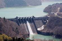
Hatogaya Dam
| Hatogaya Dam | |
|---|---|
 Downstream side | |
 Location of Hatogaya Dam in Japan | |
| Country | Japan |
| Location | Shirakawa, Gifu Prefecture |
| Coordinates | 36°14′54″N 136°53′36″E / 36.24833°N 136.89333°ECoordinates: 36°14′54″N 136°53′36″E / 36.24833°N 136.89333°E |
| Purpose | Power |
| Status | Operational |
| Construction began | 1954 |
| Opening date | 1956 |
| Dam and spillways | |
| Type of dam | Gravity |
| Impounds | Shō River |
| Height | 63.2 m (207 ft) |
| Length | 331.5 m (1,088 ft) |
| Dam volume | 206,000 m3 (269,000 cu yd) |
| Spillway type | Crest overflow, 6 tainter gates |
| Reservoir | |
| Total capacity | 33,539,000 m3 (27,191 acre·ft) |
| Active capacity | 4,387,000 m3 (3,557 acre·ft) |
| Catchment area | 580 km2 (220 sq mi) |
| Surface area | 1.51 km2 (0.58 sq mi) |
| Normal elevation | 550 m (1,800 ft) |
| Power station | |
| Operator(s) | Kansai Electric Power Co., Inc. |
| Commission date | 24 November 1956 |
| Hydraulic head | 81.2 m (266 ft) |
| Turbines | 1 x 43 MW Francis-type |
| Installed capacity | 43 MW |
The Hatogaya Dam is a gravity dam on the Shō River about 2 km (1.2 mi) south of Shirakawa in Gifu Prefecture, Japan. It was constructed between 1954 and 1956. The dam has an associated 43 MW hydroelectric power station which was commissioned in 1956. Of the nine dams on the Shō River it is the eighth furthest downstream.[1]
See also
- Tsubawara Dam – downstream
- Miboro Dam – upstream
References
- ↑ "Kansai Electric Power Hatogaya power plant" (in Japanese). Suiryoku. Retrieved 28 July 2013.
| Wikimedia Commons has media related to Hatogaya Dam. |
This article is issued from Wikipedia - version of the 11/19/2015. The text is available under the Creative Commons Attribution/Share Alike but additional terms may apply for the media files.