Okurodani Dam
| Okurodani Dam | |
|---|---|
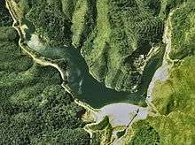 Overhead of the dam and reservoir in 1977 | |
 Location of Okurodani Dam in Japan | |
| Country | Japan |
| Location | Shōkawa, Gifu Prefecture |
| Coordinates | 36°02′27.45″N 136°52′54.01″E / 36.0409583°N 136.8816694°ECoordinates: 36°02′27.45″N 136°52′54.01″E / 36.0409583°N 136.8816694°E |
| Purpose | Power |
| Status | Operational |
| Construction began | 1969 |
| Opening date | 1971 |
| Dam and spillways | |
| Type of dam | Embankment, rock-fill |
| Impounds | Oshirakawa River |
| Height | 34 m (112 ft) |
| Length | 140 m (460 ft) |
| Elevation at crest | 971 m (3,186 ft) |
| Width (crest) | 8 m (26 ft) |
| Dam volume | 279,600 m3 (365,700 cu yd) |
| Spillway type | Crest overflow, 1 tainter gate |
| Reservoir | |
| Total capacity | 765,000 m3 (620 acre·ft) |
| Active capacity | 220,000 m3 (180 acre·ft) |
| Catchment area | 64.6 km2 (24.9 sq mi) |
| Surface area | 87 m2 (0.021 acres) |
| Normal elevation | 967 m (3,173 ft) |
| Power station | |
| Operator(s) | Kansai Electric Power Co., Inc. |
| Commission date | 4 November 1971 |
| Hydraulic head | 210.8 m (692 ft) |
| Turbines | 1 x 21.2 MW Francis-type |
| Installed capacity | 21.2 MW |
The Okurodani Dam is a rock-fill dam on the Oshirakawa River (a tributary of the Shō River) about 7 km (4.3 mi) west of Shōkawa in Gifu Prefecture, Japan. It was constructed between 1969 and 1971. The dam has an associated 21.2 MW hydroelectric power station located about 3.5 km (2.2 mi) downstream which was commissioned in 1971.[1]
See also
- Miboro Dam – downstream on the Shō River
References
- ↑ "Power Development Onoe Township power plant" (in Japanese). Suiryoku. Retrieved 28 July 2013.
This article is issued from Wikipedia - version of the 11/19/2015. The text is available under the Creative Commons Attribution/Share Alike but additional terms may apply for the media files.