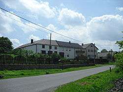
Heřmanice u Oder
| Heřmanice u Oder | |||
|---|---|---|---|
| Municipality and village | |||
 | |||
| |||
 Heřmanice u Oder Location in the Czech Republic | |||
| Coordinates: 49°42′25″N 17°48′7″E / 49.70694°N 17.80194°ECoordinates: 49°42′25″N 17°48′7″E / 49.70694°N 17.80194°E | |||
| Country |
| ||
| Region | Moravian-Silesian Region | ||
| District | Nový Jičín District | ||
| Area | |||
| • Total | 4.61 sq mi (11.95 km2) | ||
| Elevation | 1,594 ft (486 m) | ||
| Population (2012) | |||
| • Total | 322 | ||
| • Density | 70/sq mi (27/km2) | ||
| Time zone | CET (UTC+1) | ||
| • Summer (DST) | CEST (UTC+2) | ||
Heřmanice u Oder is a village and municipality in Nový Jičín District in the Moravian-Silesian Region of the Czech Republic.
| Wikimedia Commons has media related to Heřmanice u Oder. |
This article is issued from Wikipedia - version of the 4/7/2016. The text is available under the Creative Commons Attribution/Share Alike but additional terms may apply for the media files.