Wakari

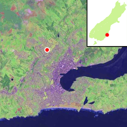
Wakari (/ˈwɒkəriː/ WOK-ə-ree or local /waɪˈkæriː/ wy-KARR-ee) is a residential suburb of the New Zealand city of Dunedin. It is located 2.5 kilometres (1.6 mi) to the northwest of the city centre, immediately to the west of the ridge which runs to the west of the city's centre. Wakari lies to the north of the upper reaches of the Kaikorai Valley, and is also north of the suburb of Kaikorai. The suburbs of Roslyn and Maori Hill are situated on the ridge immediately to the southeast and east of Wakari. The suburb of Halfway Bush lies to the northwest, and the smaller suburb of Helensburgh lies to the north.
The population was 3,069 in the 2006 Census, a decrease of 39 from 2001.[1]
Wakari's name is likely to be a corruption of the Māori Whakaari, which translates as "a raised view". This was the name for the hill, Flagstaff, which lies 2.5 kilometres (1.6 mi) to the northwest.
The suburb is bounded in the south by Taieri Road, a main suburban arterial route which links central Dunedin with the Taieri Plains. West of Halfway Bush, the road becomes Three Mile Hill Road, crossing the eponymous hill to reach the Taieri Plain northeast of Mosgiel. To the southeast of Wakari, Taieri Road runs under the Roslyn Overbridge and becomes Stuart Street, one of central Dunedin's main streets. Other main roads in and around Wakari include Balmacewen Road in the northern part of the suburb, Helensburgh Road in the northeast, Nairn Street, and Shetland Street.
Wakari's most prominent structure is the Wakari Hospital, one of Dunedin's main health care centres, which specialises in psychiatric services. This hospital is located in the west of the suburb, close to its boundary with Halfway Bush.
Helensburgh
The small suburb of Helensburgh is located immediately to the north of Wakari and east of Halfway Bush.[2] It is located on a series of small crescents which branch off the northern side of Helensburgh Road and off Wakari Road, which runs roughly parallel with Helensburgh Road some 300 metres (980 ft) to the northwest (confusingly, this means that Helensburgh Road is largely in Wakari, and Wakari Road is largely in Helensburgh). Wakari Road, a long, straight semi-rural road, links Taieri Road with Glenleith, 1.7 kilometres (1.1 mi) to the northeast, by way of the forest plantations surrounding Ross Creek Reservoir. Helensburgh is bounded in the northeast by the Balmacewen Golf Course.
References
- ↑ Quickstats about Wakari
- ↑ "Place Name Detail: Helensburgh". New Zealand Geographic Placenames Database. Land Information New Zealand. Retrieved 2008-12-03.
Coordinates: 45°51′32″S 170°29′00″E / 45.85889°S 170.48333°E