Henwood Down
| Henwood Down | |
|---|---|
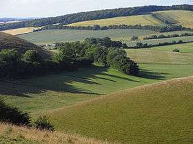 Downland above Coombe, East Meon, with Henwood Down behind. | |
| Highest point | |
| Elevation | 201 m (659 ft) [1] |
| Prominence | 64 m (210 ft) [1] |
| Parent peak | Butser Hill [1] |
| Listing | Tump |
| Coordinates | 50°59′35″N 1°03′32″W / 50.993°N 1.059°WCoordinates: 50°59′35″N 1°03′32″W / 50.993°N 1.059°W |
| Geography | |
| Location | Hampshire, England |
| Parent range | South Downs |
| OS grid | SU661219 |
| Topo map | OS Landranger |
Henwood Down is one of the highest points in the county of Hampshire, England, and in the South Downs, reaching a height of 201 metres (659 ft) above sea level. Its prominence of 64 metres qualifies it as a Tump.[1]
Henwood Down rises about 1 mile west of the village of East Meon in Hampshire and around 2 kilometres northeast of Old Winchester Hill. The northern slopes are covered by mixed forest (Hen Wood), whilst the southern flanks are open. The South Downs Way runs over the southern spur of the hill.[2] The hill is part of the Winchester-East Meon Anticline.[3]
References
- 1 2 3 4 Summit Listings by Relative Height by Mark Jackson, compiled by Jonathan de Ferranti. Accessed on 15 May 2013.
- ↑ Ordnance Survey 1:50,000 Landranger series.
- ↑ Fareham, British Geological Survey 1:50,000 Map Series, Sheet 316, NERC, 1998, ISBN 0-7518-3168-9
This article is issued from Wikipedia - version of the 11/9/2013. The text is available under the Creative Commons Attribution/Share Alike but additional terms may apply for the media files.